The personal authentic travels of a world-wide drifter, you'll always see pics of me at the locations being described (if the other blogs you're reading don't do that, odds are they were NEVER there, just saying…)
Category: Tourist Attractions
These are permanent things that exist both for the local population (museums, amusement parks, areas that protect and explain local history, etc), but also in a determined effort to attract in tourism to the city… and sometimes these efforts offer little to no value to the locals OTHER than to bring in tourist dollars …
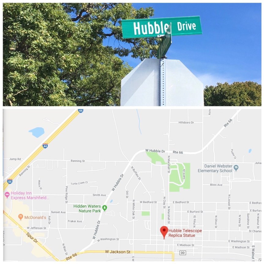
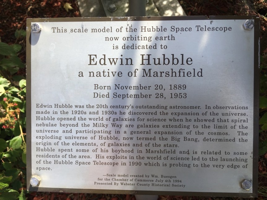
As you’re passing through small town of Marshfield Missouri on Route 66 (population 5,720, so slightly larger than my high school) if you pay attention you’ll realize that within the boundaries of the town the route bears the name of Hubble Drive; this is in honor of the town’s favorite son, the historically important American Astronomer Edwin Hubble (1889-1953)
Hubble is highly respected in the scientific community as one of the most important astronomers of ALL time. He played a CRUCIAL role in establishing the scientific fields of extragalactic astronomy (studying objects OUTSIDE the Milky Way) and observational cosmology (the study of structure and evolution of the universe, not through theory, but through things we can actually see).
And, if you choose to divert just a little bit off 66 to enter the center of town, you’ll find a 1/4 scale replica of the Space Telescope named in his honor (which makes complete sense once you realize who he was and what he did) sitting alongside the town hall.
In addition his efforts are lauded in murals I spotted around town
And YET … Webster Country, where Marshfield is located is a deeply Republican area and voted 76.9% in favor of Trump… And Marshfield is 97.8% lily white…. So what do you want to bet that the old guy is turning over in his grave because most of his hometown’s residents believe science is a bad thing?
Located on a frontage road adjacent to Route 66/I 44, is what I’m guessing is the worlds biggest bottle of liquid life, a product that to be honest I’d never heard of before — and I’m guessing it’s the largest cause I doubt there’s another one like it anywhere.
It is standing in front of the headquarters for the TRC Corporation, which makes the stuff. From what I can tell TRC’s major concern is actually minerals from mining. There is nothing on the internet describing why this bottle is here, and it’s only noted on the various Road tripping sites by people who’ve passed it.
On the topic of how to take a photo like this when traveling alone? My iPhone is sitting on the hood of my car, and I used the remote control on my apple watch to activate it.
Originally built as a symbol for the International Petroleum Exposition held in Tulsa Oklahoma (ever four years) in 1952 (and then temporarily again in 1959) the Golden Driller, is a statue of a Paul Bunyanesqe Oil worker. At 75 feet tall (23 meters), he stands majestically with his right arm resting on the top of an honest to G-d oil derrick (moved here from a depleted oil field in Seminole, OK), and is the 6th tallest statue in the United States — with Lady Liberty still being our tallest at 151 feet (not including her base)
As a result of how popular he was with Oklahoma natives, the exposition donated him to the Tulsa Fair grounds in 1966, this time as a permanent fixture.
He is located just a mile south of Route 66, on the Tulsa County Fairgrounds, and was officially declared the states monument in 1979 by the Oklahoma Legislature, and as such, he’s one of the few locations in my “big things” category that can easily be found on T-shirts and mugs, etc.
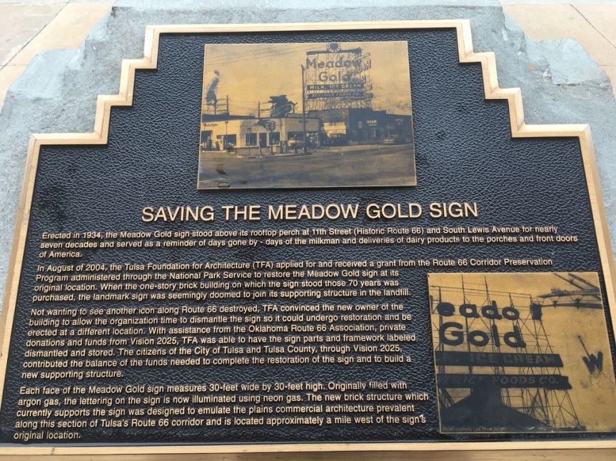
If you drive down Route 66 in downtown Tulsa Oklahoma you can’t but see the Meadow Gold Sign. All of the “what to see” sources had talked about this sign as an iconic Route 66, and when I first saw it I had assumed (never assume) that they had destroyed the original building but they kept the sign — and thought that there was something glorious about that… but I was wrong. While the sign had always been on historic Route 66, its original location had been at about a mile East (but still on the route) at the corner of 11th Street and Lewis Avenue.
The sign is in fact a set of two signs that once stood back to back (note the back of the 2nd in the picture above), but is now set at a sort of V alignment. This was done to serve its new purpose, as historical art, that has been made easily visible to traffic moving in either direction on route 66.
Originally installed in the 1930’s, on top of a small one story building, the sign’s lights started going dark in the 1970’s. Once the building where it had sat was destroyed (now an “Advanced Auto Parts” store) this iconic to the city neon-sign was saved from the wrecking ball, and began to be restored in 2004 (to the tune of $337K), and moved to this new location on Route 66, which was donated to the city for this purpose. What it stands upon is more of a shelter from the elements, than a building, and has a collection of brass plates explaining bits of the history of the sign.
The restoration and moving of the sign was a project that involved many hands. Initially the Tulsa Foundation for Architecture (TFA) had received a small grant of $15K from the National Park Service‘s (NPS), Route 66 Corridor group to restore the neon sign. This was done through their “National Center for the preservation of Technology” group, among whose stated goals is the preservation of the neon signs along Route 66. This is being undertaken in recognition that neon signs are not JUST advertising, they are a form of functional-art; and that together, these signs help to evoke earlier times along Route 66, but that are just like our historic buildings are currently under threat by neglect or demolition and can only be saved from the shortsightedness of the market place by government intervention. Maintaining these past technological structures is important not only historically, but also because it supports local economies through tourism.
Once the initial seed funding ($15K) had been secured by the TFA from the NPS, this “primed the pump” so to speak, making it easier to raise matching funds from other sources — to the tune of $322,273, the actual cost of restoration. Among these were the privately funded National Trust for Historic Preservation, the Oklahoma Route 66 Association. And then more funds were collected from the public at large via the City’s Vision 2025 initiative; this was a new one cent tax increase that would be maintained for 13 years whose proceeds were earmarked towards economic development and capital improvement projects, such as saving the Meadow Gold sign — but that had to be agreed to by the voters of Tulsa County.
This tax was ultimately instituted, in part as a result of multiple newspaper articles about how the sign was in danger of being destroyed, and that funding was desperately being at first being sought, and this new tax was needed to that end.
Mural on a wall directly facing the sign’s location, I’m assuming this was in regard to raising the money needed (over $300) to save an Iconic Route 66 sign
Meadow Gold had been a dairy brand that belonged to the Beatrice Foods Company, founded in 1894 initially as the Beatrice Creamery Company, and then incorporated in 1905 as the Beatrice Creamery Company of Iowa. During that time they had begun the Meadow Gold dairy brand — which by World War II was a household name in much of America, and had branched out into the development of other dairy products … so that in 1946 the company changed its name yet again to simply the Beatrice Foods Co., as visible on the sign.
That said, the in the 1980’s the Beatrice fell on hard times mostly of their own construction. They lost a major lawsuit against them for toxic dumping (which resulted in an award-winning book and a film called A Civil Action), and they operated in South Africa during apartheid and hence suffered from some boycotting. As the company had taken on many other non-food business over the years, in 1984 they changed their name from Beatrice Foods Co. to Beatrice Companies, Inc., and then sold off their Meadow Gold Brand, along which was now part of their Beatrice Dairy Products, Inc., subsidiary, along with a couple of other brands, to Borden, Inc. in December 1986 for $315,000,000. Borden then went defunct in 2001, so that the Meadow Gold brand (which is still an American household name) is now owned by Dean Foods.
Interestingly, I did not find a SINGLE source talking about how the Meadow Gold brand or Dean foods chipped in to help save the sign advertising THEIR product. BUT, I could of course be wrong, and maybe they did so anonymously — which from a political standpoint would make sense.
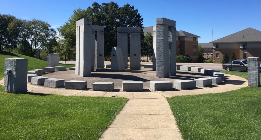
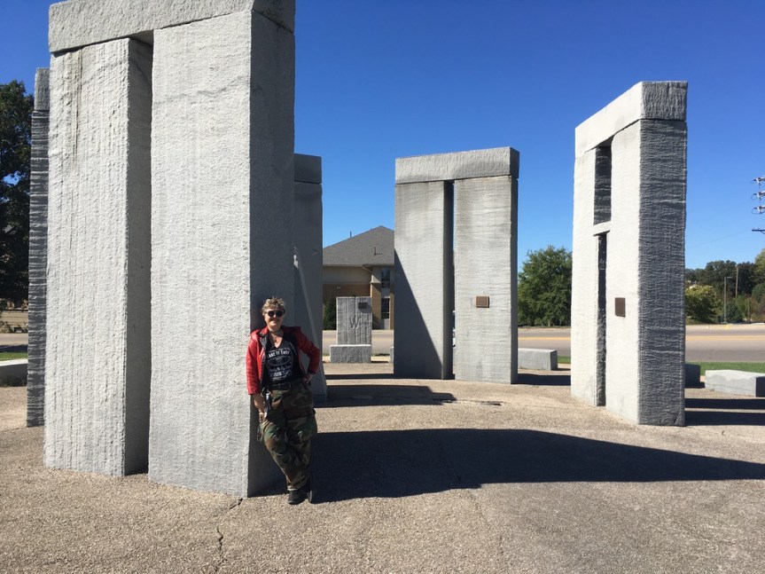
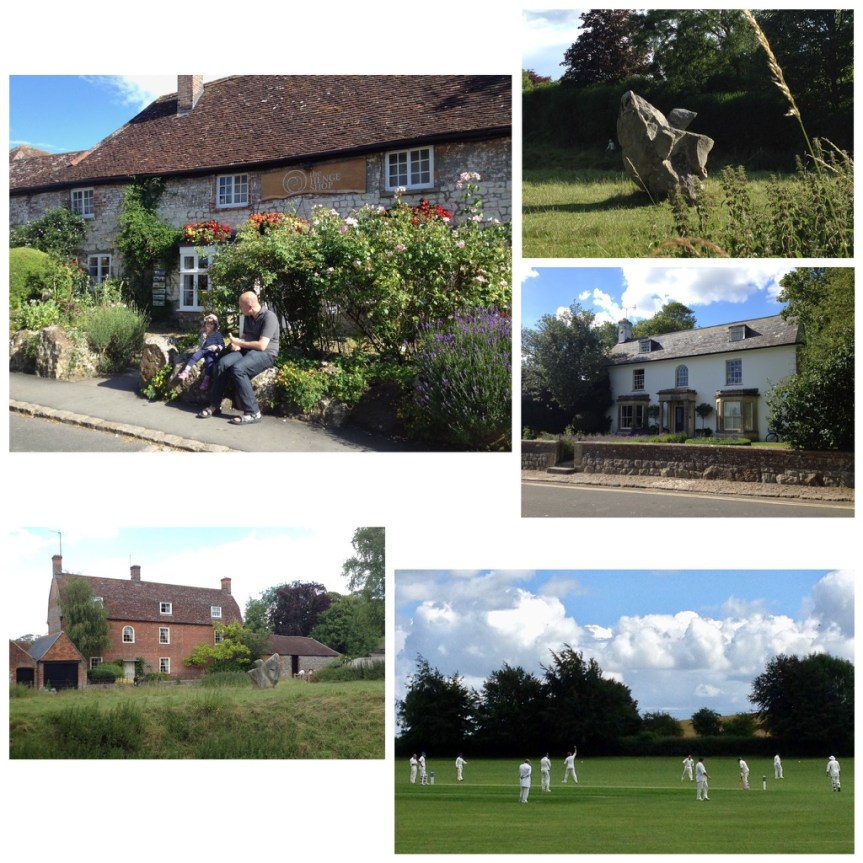
Located right off of Historic Route 66 as it meanders through the town of Rolla Missouri and passed the Missouri University of Science and Technology, is a half sized version of Stonehenge, similar to the one on in Amesbury on the famous Salisbury Plain of England.
Sometimes referred to as the Stubby Stonehenge, according to their website the structure this ‘functional art’ ….
… works just the same way that the original Stonehenge, as a solar calendar… only in this case it comes with annotations in the form of etchings into the stone and plaques placed on the various rocks… and it
“stands for many things; a lasting monument to man’s drive for knowledge and engineering, the largest monument to ever be cut with a water-jet, and a link from the past into the modern. It was dedicated on June 20, 1984 or the summer solstice, at the site of the northwest edge of campus. Approximately 160 tons of granite were used in the monument. The rock was cut to the proper dimensions by Missouri S&T’s Water-jet equipment.”
According to other websites, it was mostly something to do to show off how good their High Pressure Water Jet Lab was at stone carving. Although I also found an FAQ page put up about the place by the University
Somehow I did not spot this on any of the preparatory maps that I used when planning this Route 66 road-trip… so to just happen to drive by it, unexpectedly… it was a super cool surprise…. it made the geek in me very happy…..
Of course this also gives me opportunity to include some images I took back on July 3, 2014, when I was at the REAL prehistoric Stonehenge site near Amesbury … less than a month before my father died. I had gone to the UK to present an academic research paper at a conference at Keele University near Stoke-on-Trent, and afterwards had gone to visit a friend of mine who USED to work for Google in SF (she was on the team the created Google mail) but who had grabbed her golden parachute when her stock options matured a few years before, and had retired to Bristol in the UK, about an hour drive away from Stonehenge.
For an explanation of the fences behind me, keep reading
[My T-shirt reads: “English doesn’t borrow from other languages. English follows other languages down dark alleys, knocks them over and goes through their pockets for loose grammar.” Why yes, I’m a geek, what’s your point?]
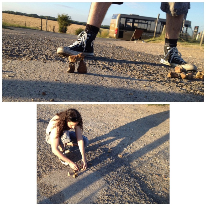
I remember that I got there late, and didn’t make it in time to actually be able to enter the site. I had “assumed” (never assume) that closing time meant closing time… it doesn’t. For Stonehenge the LAST admission to the site is TWO HOURS before the place closes, and they only let in a limited number of people at a time, so unless you’re very lucky, you’ll need to book your visit in advance (from this site), which I had not done… not to mention I showed up a half hour before closing. When I got there the guard refused me entry and told me to come back some other day, and to book my admission rather than just showing up. I almost cried… when I explained I was American and this was my last chance before heading home… he made a suggestion. He told me to drive around the henge area, to a gravel side road on the far side of the tourist entrance, where I would see a lot of other parked cars. From there, he said I could at least see it better. So I drove there… and met this new age-ie guy, making a mini- henge with rocks he found on the road…. [The paved road visible via google maps is NOT accessible to public traffic, it’s for tourist busses only]
There were in fact a LOT of new age types parked along this gravel road… they had a sort of mini community thing going on over there. Since then Folks have even noted its location in google maps, and if you zoom in you’ll see a LOAD of cars along that road, parked for free instead of in the paid lot. They ALL suggested that I walk down to the edge of the official property, at which point there’s a pedestrian accessible wooden gate to his property, with some warning signs on it about keeping your dog on a short leash and respecting that you’re on private property, etc., that opens to a path along the edge of his sheep farm and along the official Stonehenge property … and they promised me that the farmer who owns the place actually wants folks crossing his property to get a closer look — they said it was a sort of “fuck you” to the English Heritage Trust government folks — that was as long as you don’t mess with his sheep.
The view from the location of me in front of Stonehenge, but in the other direction
The ironic thing is… IF you go in the official way, while you do access to the educational tourist center, which is supposedly quite good (I have not yet seen it) … that’s not what you’re paying to see. What you’re really wanting is to get close to Stonehenge — but no one is allowed to do that anymore except on days like Solstice and other Pagan festival day like that. Somewhere we’ve got photos of when my brother and I were very young children (so like 50 years ago) and our parents took us to Stonehenge. In them you can see him on one of the rocks (I was still a toddler). But those days are LONG past… Today, ironically, the distance between this free path, and the path you’ll be paying to walk along is little enough as ‘never mind’. That said, the free way limits you to one side of the henge, while the paid path takes you all around it… but pretty much at an equidistant.
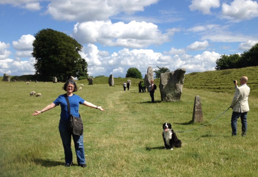
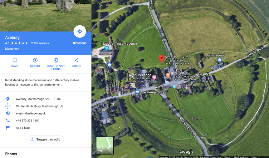
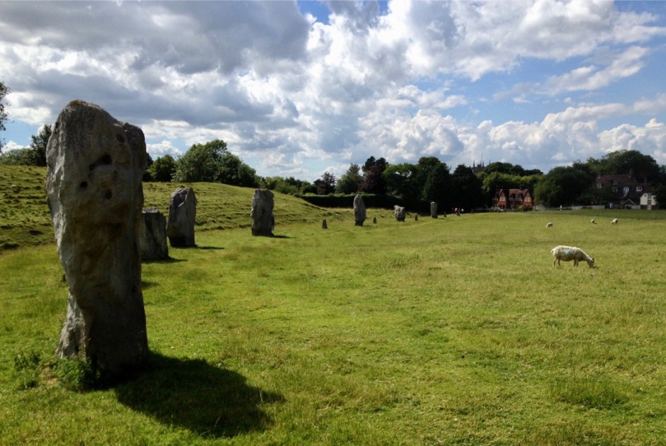
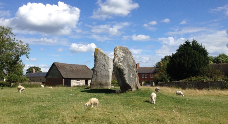
That said, three days later on July 6th, 2014, my friend who I was staying with in Bristol (she’s the one standing, wearing a backpack, with her back to the stone in the picture above) took me to an arguably more interesting, albeit less famous, prehistoric henge directly north of Stonehenge in Avebury, on what is debatably the northern edge of the Salisbury Plain (the actual edges of the plain are up for debate). This henge, which the public can STILL visit entirely for FREE and get up close and personal with the stones, is actually the largest Neolithic stone circle in Europe (in terms of ground covered). Unlike Stonehenge, which has the largest stones and as such is famous for the “how the fuck did pre-technology man get stones this big to this location?” question, that has in the past made people think aliens must have done it… This henge consists mostly groundworks, that encircle very large stones (but of the, “ok, I can see how primitive man working together might have moved these to here” size).
Here, and I was shocked when I first realized this — and you can’t but, I noticed it as soon as we drove to the location, the village actually cuts THROUGH the center of this historic henge, so that some homes actually have henge rocks in their gardens….
Note the road I was on when I took the photo cuts right through the circle, and the shot below is of the same location from a slightly different angle (you can tell from the church spires) only in the 2nd one I was up on top of one of the ground-works
In a way looking at these is sort of bitter-sweet for me. Unbeknownst to me, my father was having real health issues back in the states but he refused to tell me about them because he didn’t want me cutting my trip to England (he was British by birth) short on his account. MEN!
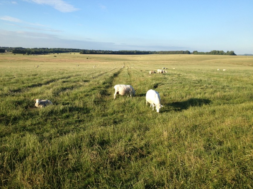
As is obvious from the above picture, this prehistoric area is actively used by locals for hiking and picnics, etc.
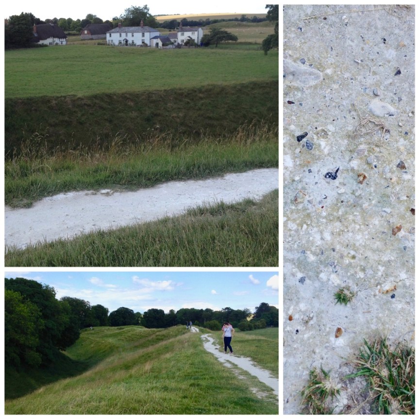
and it’s really easy to see how the ground was worked by prehistoric man, with both dug trenches into the chalk ground (which must have been very hard work) and then used that to make man-made mounds surrounding them
The top of the man-made mound, and the chalk exposed as a result of folks walking thereWhere these holes part of how they lifted and carried the rocks?
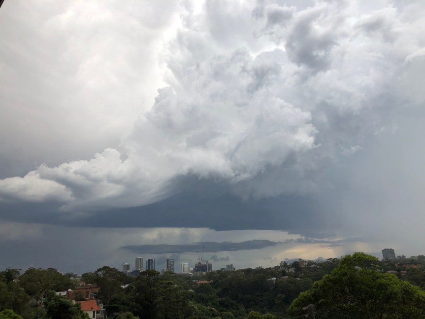
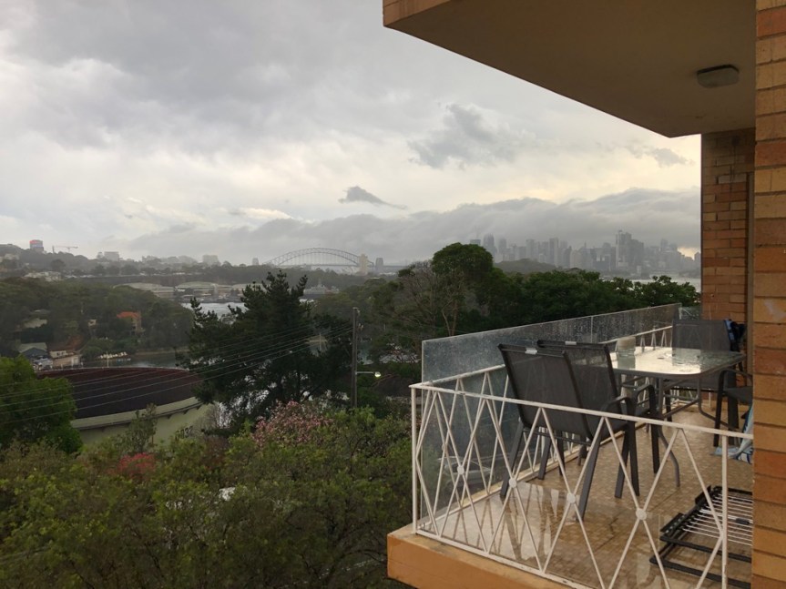
We had weather!!! This storm produced what news outlets are dubbing the worst hail storm to hit Sydney in 20 years. My friend and I were actually VERY lucky during it, we got all the pretty and excitement, and none of the damage… while the area called North Sydney, which is a short walk east of us as the crow flies (its the area of tall buildings on the right side of the image below) got tennis ball sized hail that broke straight through car windows, we only got hail the size of quarters. Apparently, all told, there were 30K lightning strikes over the four hours of the storm. News reports today put the damage into the millions, and 20K homes lost power.
Panorama shot
The plan for today was to take advantage of the fact that my one year pass for Scenic World, which I bought last year while in Katoomba, had not yet expired, and drive out there with my travel buddy and his mom. We cancelled because there was a warning of sever storms…. First we had rain coming down in sheets, then we had hail that started out pea size and graduated at about quarter size…
The little white spots on the ground are hail
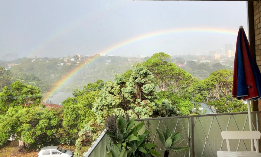
and then we got THIS. note how it seems to be starting just AT — as in in FRONT of the bushes on the far side of the street, AND its a double rainbow?! — you can’t see from this shot but its a COMPLETE rainbow
My travel buddy was in his bedroom, working — he works remotely, hence his ability to travel… but he still has to work…. and had headphones on and was missing the whole thing… when it was hailing, he was not excited… I even brought him a quarter sized piece of it that had landed on the veranda, but NOPE, unimpressed, but THIS woke him up….
This is the photo he was trying to takeAnd here’s my two arch shot… note the bridge to the right of the rainbow
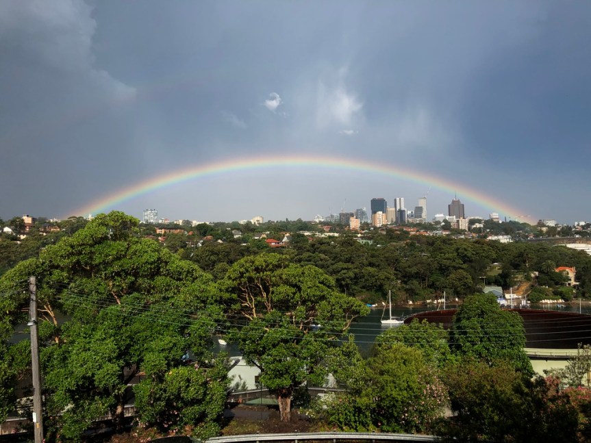
What was kind of interesting was that over time it drifted away, as in didn’t get less intense, but seemed to be more out into the distance. FIRST it was in front of the nearby bushes… but then behind them…
But then it moved out like miles away onto the horizon… so that now I could get it all in one shot without having to use panaroma…. and then 45 min later
This was going on…. …. SCARY… The cloud formation in the photo above showed up in a news article the next day…. And according to the news report it was directly over Manley Bay (a few miles east of where we are)
And its not done… at one point I had my back to the window and saw two bolts of lighting reflected in my screen as my room lit up… and there was a building shaking BOOM a second later…
All told, it appears that my weather karma is still holding.
Back in August of 2016, as I was road-tripping along the Trans-Canadian Highway on my way from Vancouver Island in the far west of the country to Stratford Ontario (just east of Detroit Michigan) I came across this really unique combination store that I liked so much that I can actually see myself driving back there (albeit, on a more direct route next time) to buy things for my home… once I actually get one.
It’s actually a combination of a few stores that is only open during the tourism season (closed in winter, even just before Xmas — which is a bit crazy if you ask me), as well as a liquor store and gas station which stay open all year round.
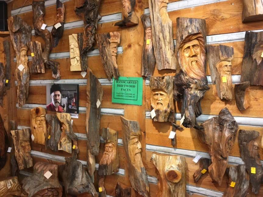
while the Canadian Carver is a gift store, full of hand-made items from local artists
…some that looks a lot like cheesy stuff you could buy on-line or from gift-shops along highways … but ALL of it is in fact hand carved by artists they represent — although of varying levels of ability….
The better stuff, from more skilled artists, is usually is grouped together on a wall
or a shelf, with a photo and description of the artist alongside the items.
Although some of it is just easy to self identify….
was seriously wanting to buy this fruit bowl (left) and table (right) for myself, but no room
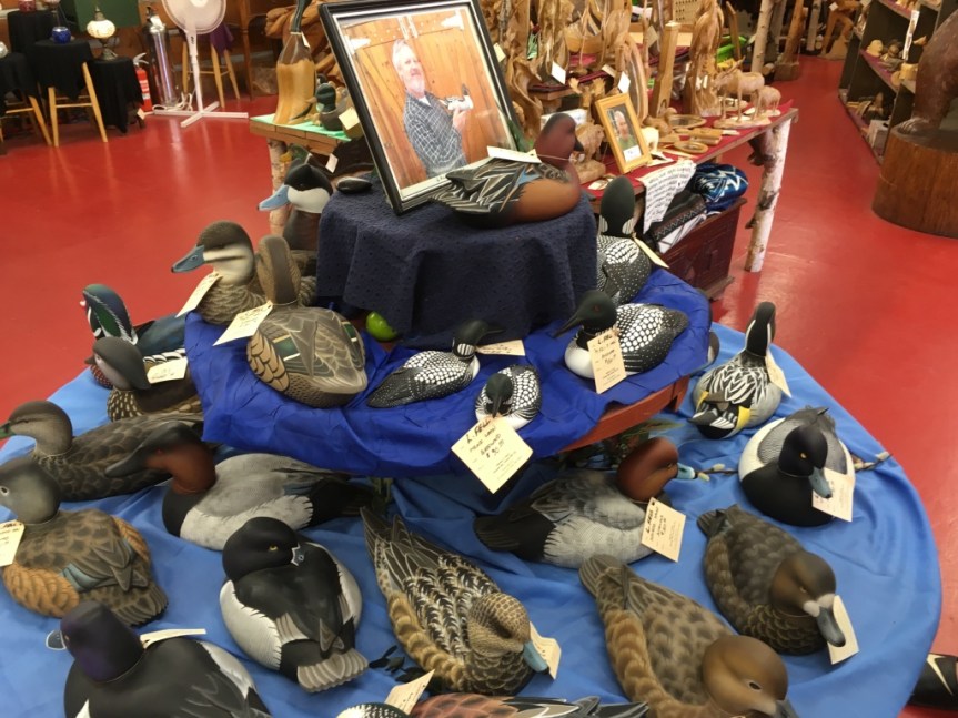
While I was here I did buy a carved duck, but as a wedding gift for two friends of mine who were getting married about a month later in September 2016, in Chicago.
I’ve known the spouse since kinder-garden, the purple dress was purchased in Victoria, and is made of 100% hemp — so comfortable
It was of a sort decoy duck, a type of traditional North American Folk Art, usually carved out of a wood that will float — and sometimes used by hunters to confuse a duck into landing near them … like in the image below, only the one that I bought was MUCH nicer
the one I bought almost looked like it was breathing … I’m sorry to say I never took a picture of it before wrapping it … my bad… that had been carved by a master level carver by the name of Larry Fell, and was signed underneath by the artist. (Works from some of the more famous master carvers have gone on to be collector’s items that have sold in the high six figures — so I figured, good gift.)
I took this photo so my friends would know who the artist was who made their piece, should it ever become a collector’s item
… which I later, while in Stratford, ON… paid to have wrapped to my specifications (because when it’s worth doing right, pay a professional) at a high-end chocolate store called Rheo Thompson Candies…
Even though it’s a candy store, when I was walking through it one day I noticed that… because of all the people in that town who like to give chocolates as wedding favors, they had wedding gift paper with butterflies on it … so I asked them if they’d be willing to wrap my gift for me even though I wasn’t going to buy any chocolate, and they said they were…. I also asked if I could have these clay butterflies, which were on display as part of something else in the store, attached to it, and they agreed. I think the wrapping cost me like $30… but I think worth it… Getting the whole thing back to chicago without it being damaged was the tricky part.
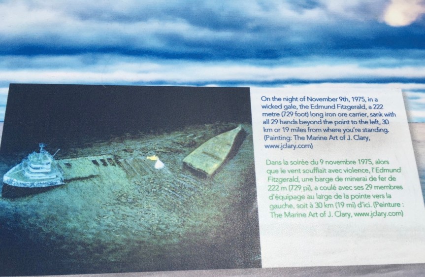
At this location along the Trans Canadian Highway there is an educational sign devoted to the wreck of the SS Edmund Fitzgerald. The Ship was a Great Lakes Iron ore freighter that sunk November 10th, 1975, during a storm that contained 25-35 foot waves and hurricane-force winds. The wreck occurred southwest of this location, in the waters of Lake Superior; The ship’s wreck was immortalized in song by the great Canadian singer-songwriter Gordon Lightfoot; and is historically important for all those who work the waters of the great lakes, for how it forever changed the safety regulations upon them.
For those who do not know, Superior is the third largest freshwater lake in the world both by volume and the largest by surface area; In fact it is so large that it contains about 10% of the worlds fresh water supply.
And, because of its impressive size and volume, it is large enough to have its own tide, just like an ocean.
And while it is beautiful, it can also be as treacherous as any Ocean — especially during the months of November.
It has had 350 recorded shipwrecks, has taken over 10,000 lives, and her waters are notorious for not giving up her dead (as in the bodies never wash up on the surrounding shores).
The Fitzgerald had been the largest freighter on North America’s great lakes when it was first launched in 1958, and to this day remains the largest to have sunk within them; and in large part this catastrophe is why no other freighters have sunk on the lakes since then.
The ship went down without a trace, taking along its entire crew of 29, and its singing, along with the notoriety the song brought it, led to changes in shipping regulations on the lakes. Now all boats must carry depth finders, higher freeboards, and undergo more frequent inspections of their sea-worthiness. In addition, these freighters are now required to carry survival suits for every member of the crew, so that even if the boat does go down, the workers can still have a chance at survival.
For those unfamiliar with the song,
I also found this 20 minute video on YouTube called, The Edmund Fitzgerald: a 40 Year Legend which goes into depth about what we know, or think happened to the ship:
The various points along the route in the photos above, see my click map
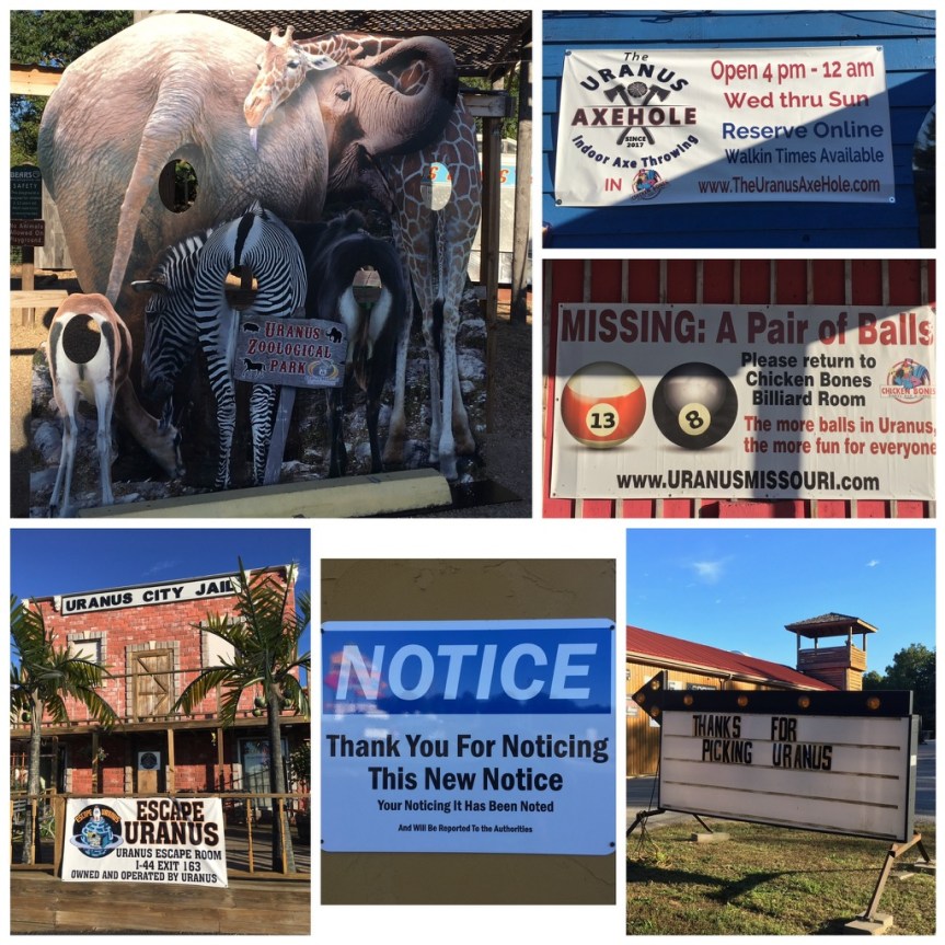
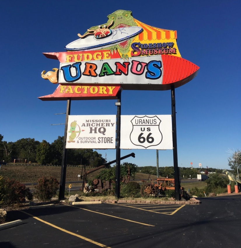
Located on Route 66, this place was advertised as a town that had taken its name and run with it…. unabashedly. This appealed to me… That said, the place turned out to be SUCH a major tourist trap that it managed to lack ANY charm, wit, or finesse at all, and the joke … which I admit totally made me want to come see the place, gets REALLY really old after the first 15 minutes of actually being there… to the point of irritating.
From everything I had read the place was a very small town with 25 residents. AND, having just driven past any number of very tiny towns along route 66, that is what I was expecting… 25 residents maintaining a few business all of which played on the name of the place in order to draw tourists to somewhere they’d have otherwise just driven through… All hail the entrepreneurial spirit!
Note, the parking lot concrete is stamped with the words “Explore Uranus”
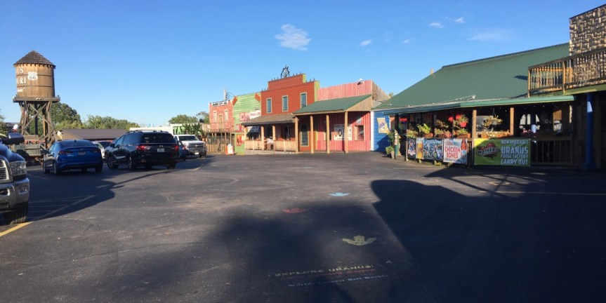
BUT, once I got there, it was very sad… Firstly, as you can see from the pictures, it’s not really a town. I was expecting a small town… a downtown with a handful of business, surrounded by a few houses… like all the other aforementioned small towns I had passed on Route 66…
Instead what I found was a massive attraction that looks like a strip mall tourist trap …. essentially a single business broken into a few separate areas….which is not just unforgivable… it’s lazy. When you arrive you see the fake water tower, intended to make it feel like a “small town” with the implication that they have a school somewhere back there, with team called “the Pirates” — but I think they’re referring to themselves… as in the way Carneys think of the customers as marks to be taken advantage of… only these guys are pirates ripping off the sea of traffic…
What was doubly frustrating was that in the gift store they have lots of magnets focused on the town’s name…. but no bumper stickers (my car is COVERED in bumper stickers)
… When I asked about that the woman working there said that up until now everyone’s wanted magnets, so they ordered lots of them… but now people are starting to ask for stickers, but those they haven’t gotten in yet… (not sure I believed her)
and apparently, just recently a big group had come in and bought out all the good women’s T-shirts (scoop or V neck) so there were none of those either — and definitely none were available in the only design that I was interested in buying — as apparently I’m not the only woman who preferred that design. She suggested I check their webpage over the coming weeks — I did, and didn’t see it there either.
By the time I was done walking around the place… and I admit I stayed longer than I might have had I not been intent on writing about the place, because this place seriously annoyed the CRAP out of me … just … that… much!!! … by the time I got done, I was seriously…. SERIOUSLY pissed at having fallen for this particular tourist TRAP
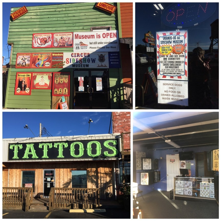
There’s also a circus sideshow museum and a tattoo parlor
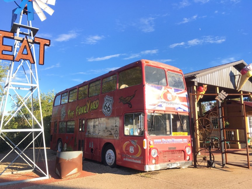
SO annoyed in fact that I managed to completely miss the fact that around there somewhere (according to Wikipedia) they’ve got the World’s largest Belt buckle … one that even has a Guinness World Book of records designation… yah, I missed that… saw the Funkyard where it’s supposed to be…. did NOT see even one sign promoting it…
Pounding head into wall… will have to go back… pounding head into wall again… THAT said, I’m not seeing it on google either…
In October, while driving Route 66, I came across this marker/monument in Oklahoma. It denotes the eastern boundary of the Oklahoma Land run of 1889. For those who are unfamiliar with this event, it is yet another one of the many moments in American history where white men feel proud of themselves (there’s a HUGE monument to the event in downtown Oklahoma City), for essentially screwing over the indigenous red man who was there first (please note there is NO reference to them on this monument). HOWEVER, it also has something to do with the Case of Carpenter v. Murphy which is currently before the Supreme Court of the United States!
In fact the Run of ’89 was the first of a series of land rushes organized by the Federal Government. These were “organized (HAH!)” events where vast numbers of WHITE settlers, 50,000 of them in this case… lined up with a flags in their hands, and at the sound of a gun were supposed to surge across the UNASSIGNED countryside on horseback or in wagons, racing to outpace the other contestants, find a nice piece of desirable FREE land, drive their flags into said piece and thereby “stake their claim to it.” In reality, the gullible honest people did that… often to find cheaters (usually rich people who had illegally surveyed the land ahead of time) already there (along with all their employees) trying to make it look like they’d actually done the run along with the others… when they had not… and had somehow managed to grab all the best bits of land first. So this was not only White people screwing over Red people, it was also rich white dishonest people screwing honest hardworking poor white people.
Of course, all of this screwing was only possible after the government had “legally” screwed the folks who were already there…. the Native Americans…. Initially this was done via the Indian [land] Appropriation Acts where the government gave itself the right to yet again round up the local Native American population, this time to force them into reservations. When I say yet again, you need to keep in mind that the State name, Oklahoma, is derived from what it had been called at that time… i.e., the Oklahoma territory… and that the word Oklahoma is actually a composite of the Choctaw words “okla” and “humma,” which translates quite literally to “red people” … i.e., Red man’s territory.
This was an area that had at first been occupied by the Choctaw Nation (a multi-tribal people that spread from Oklahoma to Florida, and were united by a single language, Choctaw), who were then joined by the Cherokee… who were only there because they had already been moved once. Some came begrudgingly, as a result treaties they had signed, such as that of New Echota — the one made with the leaders of the former capitol of the Cherokee people( which I had visited twice, located about 1.5 hours from my friend home in Dalton, Georgia) with the Federal government; and if individual Cherokee refused to go by choice, they were FORCED to do so, on what later became known as The Trail of Tears. Ultimately, all of the Native Americans living within “Indian Territory” had been members of what the American colonists had referred to as the “Five Civilized Tribes“….Native Americans groups from along the southeast sections of America who had tried to get along with the invaders by going along; groups who had converted to Christianity, adopted centralized forms of government (see my posts about New Echota), were literate (see my post about Sequoyah), participated not just in trade but in the market economies of their areas, AND, to top it all off… OWNED SLAVES (see my post about Chief Vann, who maintained a plantation just north of Echota). All of these tactics of compromise ultimate failed, and now… having already been relocated to Indian Territory — which was supposed to be JUST for them… they were removed yet again, forced into reservations, and what had been their land, was now deemed “unassigned,” was given away to white people… who grabbed it in the mad rush described above.
And the bleeding of the tribal lands in Oklahoma has in fact continued to this day so that only 2% of what had been Cherokee Nation land is still under their own control. Now here’s the good news… AFTER I had already driven past this area, on November 27, 2018 the Supreme court heard a case called Carpenter v. Murphy that calls into question whether the tribes of the Five Civilized Nations STILL have sovereignty over its own people on lands that had sort of bled out of their control within the Indian Territory lands in last 100 years.


 Originally installed in the 1930’s, on top of a small one story building, the sign’s lights started going dark in the 1970’s. Once the building where it had sat was destroyed (now an “Advanced Auto Parts” store) this iconic to the city neon-sign was saved from the wrecking ball, and began to be
  The restoration and moving of the sign was a project that involved many hands. Initially the


 What was doubly frustrating was that in the gift store they have lots of magnets focused on the town’s name…. but no bumper stickers (my car is COVERED in bumper stickers)
 and apparently, just recently a big group had come in and bought out all the good women’s T-shirts (scoop or V neck) so there were none of those either — and definitely none were available in the only design that I was interested in buying — as apparently I’m not the only woman who preferred that design. She suggested I check their webpage over the coming weeks — I did, and didn’t see it there either.