The Gemini Giant: Wilmington, IL

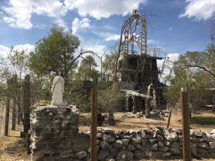
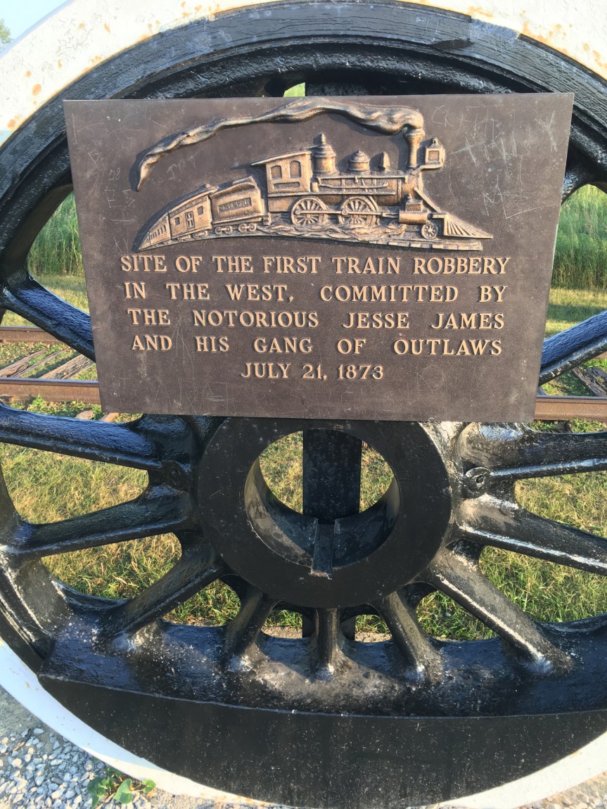
UPDATED: I first visited here in August of 2018, came back again two months later:
The Gemini Giant is 28 feet tall fiberglass “bit Thing” named after the Gemini space program of the 1960’s, located on Historic Route 66, (it was one of the very first major highways in America, was built in the 1920’s … and is also known as the Will Roger’s Highway, the Main Street of America, or the Mother Road). 
 This roadside attraction was built during the very beginning of the space race as a way to lure travelers off the road with a photo opportunity, in the hope that they’d stay long enough to buy a hotdog or a drink.

fullsizeoutput_432c.jpeg

The statue stands directly adjacent to Route 66 (yes, really, it’s the nondescript two lane road in the picture)

IMG_3574.JPG

and is in the parking lot of the Launching Pad restaurant (which was once a drive-in)

IMG_3577.JPG

The restaurant was built in 1956 at which point it was a 600 square-foot shack…they actually hired Hopalong Cassidy (well, the actor who in the 1950’s played the character in a series of sixty-six movie serials based on the character, William Boyd) to come and cut the opening ribbon (Boyd is the one in the cowboy hat)

IMG_3579.JPG

(According to the owner of the Launching Pad, who was thrilled to share the places history with me, after the show ended Boyd had gone to the studio and bought the licensing rights to the name Hopalong Cassidy for $450,000, a lot of money in those days… and in a few short years turned it around into $5 million by putting his picture and name on lunch boxes. I will note that Wikipedia disputes some of this but hey…)IMG_2160.JPG The new owner went on to tell me that the same family owned it for the next 50 odd years, passing it through the generations (and it was always wildly successful that whole time, open from around 7am to midnight — at least I think that’s what he said — with a staff of 20, and always doing good business) until 2010 at which point they sold it to somebody outside of the family who ran the business into the ground in the course of two short years (by buying cheaper ingredients, refusing to run the air conditioning, etc, all in an attempt to increase his profit margins I assume). As such, this Route 66 landmark business quickly went broke as its bread and butter local customers abandoned it, and has stood empty until this new owner bought it in 2017. The new owner is financing it solely from his own pocket and with any money he’s made by merchandising the image on T-shirts and bumper stickers and what not.

IMG_2163.JPG
Note the high quality Route 66 paraphernalia, MOST of which name the store or have the image of their iconic rocket man

He told me he has licensed the image of the giant (something the previous owners never bothered to do), so that nobody else can replicate it and he has tracked down all the old recipes for their dishes and intends to have the kitchen up and running in about two months. Till then, he’s filled the restaurant with a random collection of memorabilia intended to keep visitors happy. IMG_2164.JPG

IMG_3575.jpg

Even without the restaurant up and running, he told me that nn a slow day he says an average of about 200 people showing up in the store/resturant, while on a fast day it’s 500 to 800 people coming in from all over the world because they’ve heard about this place. Just during the time I was there, for about half an hour at about 2:30 in the afternoon on a Wednesday, I saw a Chinese guy and a French couple stop in to check the place out, all of whom were folks that were road-tripping Route 66 on motorcycles.

IMG_3560


Return 2 months later:

Full circle achieved. Stopped here the first time while driving from Pennsylvania (Pennsic) to San Francisco via I-80, and came back two months later while doing Route 66 in Atlanta, IL, where I came across this sign about an hour down south of here.

fullsizeoutput_4dc3

Had a nice long talk with the wife…. last time I met the husband… and bought two T-shirts from they. While these guys have a lot of the same Route 66 stuff other people do, the wife has also put in the effort to have a whole SLEW of T-shirts made up that commemorate THEIR store, the Giant out front and route 66 all at the same time. (My major complaint with businesses/cities along the route is that most are just lazy and order stuff that I could easily and cheaper buy from Amazon).

IMG_2436

She apparently recognized me (although we had not met) which makes me think they saw this blog post…. and talked with me about the renovations that they’re doing. One of the things I noticed immediately was that the front rooms, which on my last visit were CRAMMED with stuff so that the tables rather than being available for customers were instead covered in collectable chachkies that were NOT for sale… which included a whole collection of expensive guitars and Blues Brothers dolls had now been cleared out… (see images from my first visit). I asked her what had become of them, “didn’t these tables used to be covered in stuff? Where did it all go?” and she took me into a back where they are creating a dedicated museum space in the back of the restaurant… which was not there last time I came.

IMG_0293
I remembered see almost ALL of this stuff crowded into the front room my last visit

Then she talk with me about what they’re doing redoing the plumbing and the timetables for that, and how they didn’t did not want to get funding from the 66 foundation in order to be able to pay for it, and why… but would rather do it out of pocket and owe no one. That said, she said that had done a REALLY good business this season in the T-shirts and collectables.

IMG_2434

She said that their timetable currently is to be serving food by March, but it will be simpler stuff like hot dogs and ice cream and things of that sort, while they continue to renovate the kitchens… and that they hope to be back to full diner status maybe by November of 2019. Since that’s the end of the tourist season, they’ll be able to start up slowly, serving the local community, and then be “ready” when the tourist season begins the following spring.

Advertisement

An experiment of history, The Lagrange Phalanx, in Lagrange Indiana

Had never heard of these folks till I passed this sign. From the sound of it, they were an experiment in kibbutzim, the communal villages that exist (but are also for the most part failing) in Israel for the last 70 years. Apparently there were 33 of these scattered around the then United States, most of which were formed between 1841 and 1869, none of which lasted more than a handful of years.

9BP+jgtuTcyLGH55G1pmrQ

Drove by this Marker while driving from Ohio to Chicago upon a diversion route off route I 80/90 (i.e., the Indian Toll road) on to State route 20 (apparently there was an accident or something slowing traffic ahead of me).

Version 2

The sign reads: “The Fourier System of communal living was attempted here between 1843 and 1848. Approximately thirty families lived by rules established in councils of industry, commerce, justice and education. Their “new social order” was a failure.”

the marker isn’t shown on google maps, so I am putting a link to the closest business I could find. It’s a bit west of that, near the corner of Route 20 and the Turkey Creek


The Road Kill cafe and bar in Seligman, Arizona on Route 66

After my post about Ole’s Big Game Steakhouse in Paxton, Nebraska, off of I-80, one of my friends on Facebook said that if was doing Route 66 on my return trip, I should check out the Road Kill Cafe and bar in Seligman, Arizona, that I’d love it. But I’m afraid that after Ole’s it was HIGHLY unimpressive.

IMG_7907.jpg

Located half way (1 hour in either direction) between the larger towns of Kingman and Flagstaff, Seligman Arizona takes its place on route 66 VERY seriously… it sort of has to, it’s really got not much else going for it. (even if you needed gas, odd are you filled up Kingman or Flagstaff). It’s initial claim to fame was as a stop on Beale’s Wagon Road, a trade route from Fort SmithArkansas to Los AngelesCalifornia … and then as a stage-coach stop. When the railroads replaced the stage coaches, it was lucky enough to be chosen to be a railroad town, complete with a Harvey House (closed in 1955, demolished 2008), but in 1984 passenger trains discontinued service to the town entirely, and now just pass it by. Cars don’t really stop there much either, as while it had been on route 66 (obviously), when I-40 came through in 1978, it by-passed the town by a few miles — and like I said, most I-40 travelers are far more likely to pit stop at Flagstaff or Kingman, than they are Seligman. As such, all traffic in the town virtually disappeared on that day, according to Angel Delgadillo, a local businessman. To its credit however (you’ve got to work with what you’ve got) the town earned itself the name of “Birthplace of Historic Route 66” ten years later, when through their successful lobbying efforts they managed to convince the State of Arizona to make 66 a “Historic Highway” — and hence spend money on creating the signs that line the 66, and the big printed out 66 symbols in the middle of it.

IMG_2928.JPG

From the outside, the Roadkill Cafe (above) is way more about shtick than Ole’s was.

IMG_4039


IMG_2929.JPG

While on the inside, the road kill cafe (above) comes in a sad second to the festival of death that could be found in Ole’s (below)…  because Pretty much everything in the photos from Road Kill is in the gift store section of the restaurant, with the eating area looking just like your average diner — it was SO mundane looking that I didn’t even bother to photograph it …. while at Ole’s there’s way more of it and it is in every spare nook and cranny the restaurant had to offer

IMG_4045

IMG_2410

Western Folklife Center: Elko, Nevada

Located in Elko, Nevada, a gold mining & railroad town located off of Interstate-80, is the Western Folk-life Center is designed to promote the cowboy heritage and way of life through their songs, storytelling, poetry (for those who don’t know, Cowboy Poetry is THING) and artwork. It is also the location for the yearly (approaching its 35th anniversary) National Cowboy Poetry Gathering and competition…. six days of poetry, music, dancing, workshops, and exhibits all of which are based in tradition but focused on the modern/rural West.IMG_4677

IMG_2765You first enter into the gift shop, which constitutes almost a quarter of the space, and actually has quite an impressive collection of items. IMG_0078Around the outer edges of the store you’ll find areas devoted to Cowboy poetry, music, and art, as you expect….IMG_0077Plus some handicrafts, including beauty products and other ranch produced handicrafts…. but the entire center of the shop???IMG_0076
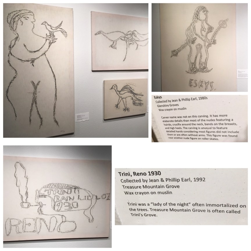
Jewelry! Lots and lots of jewelry — cause well… profit margins…. alongside the gift store is the art gallery. The guy in charge told me that they always have visiting exhibitions in this space… which switch out every few months. While I was here they had an exhibit about the art of Basque sheep herders (a different sort of cowboy) — and their art forms, including carvings, some of which date back to 1900, that are carved into local Aspen treesIMG_4720because these tree will ultimately die, a married couple had gone around collecting rubbings of all the ones they could find. IMG_0080

IMG_0081

IMG_0082

This was followed up by a small display about Basque improvised Poetry. Here they give them a topic and they have to come up with a poem on the subject … which was won by a woman for the first time last year

IMG_0083

Then there was a permenent display, of the movie why the Cowboy sings…. only its the 16 minute version

IMG_4716

Looking online I found the PREVIEW of “Why the Cowboy sings” (1.24 min)

As well as the Full 56 min movie — but no 16 minute version

IMG_4715.jpg

After this the docent showed me their western bar… it was not specially made, they found it in a mining camp in a tent and brought it here

IMG_0079

Some examples of Cowboy poetry:

This website shows last year’s “Best of the West” show, which is a yearly performance at the Poetry Gathering, which exhibits some of the best of modern Cowboy music. While this video on the event, gives you an idea of the full breath and depth of it:

Cemetery in a roundabout: West Des Moines, Iowa

Currently situated in the middle of the intersection at South 88th Street and Mills Civic Parkway in West Des Moines, Iowa (not far from I-80), lies the Huston Family Cemetery. It was named for James B. Huston, the patriarch of one of the first families to settle in Dallas County (in the 1840’s) and the LAST person buried at the plot (in 1889). The cemetery is unusual in that it now sits in the center of a roundabout in what was once a rural area, but that is no only about a mile away from a Costco, and as there’s already been one instance of a drunk driver driving through the site, it might end up being moved — although there is some talk of moving the roads instead.

IMG_3859.JPG

The area which I’m fairly sure was completely rural a few years ago (like the other grave in a middle of the road I visited in Indiana) is to the graveyards detriment being developed REALLY quickly, according to the locals I spoke to … so much so that — like I already said–  there’s a Costco about a mile directly down the road (with a gas station, which I filled up at).

IMG_3858.JPG

The Huston Cemetery consists of 19 graves that date back to the late 1880’s, and are located near to The family’s original home — which is still standing nearby. The home is HIGHLY historical, as it was once a stage-coach station, a tavern, the local post office AND a stop on the Underground Railroad. The family patriarch, James B. Huston, was the first attorney in Dallas County (where the graves are situated)

IMG_2764.JPG

According the city’s website, the first two former slave girls, both named Harper, who apparently had “died on their way to freedom” were the first individuals buried there — although this is conflicted by a report from another site, which claims the two girls were part of family that was on its way to Kansas to become part of John Brown’s raiders. They were followed by James Huston’s wife, Nancy Hill Huston, and six of their children, all of whom died young — so there’s a sad story to be told from these stones.


Route 80’s Little America Travel Center: Little America, Wyoming

I have always really loved the Little America Travel Center just off of Intestate 80 west of Green River, Wy; and I have stopped here many times over the years. When I first discovered it, it had been recently renovated and stood as an oasis of green in the desert of western Wyoming, serving up decent food at very reasonable prices. It USED to be impressively shiny (ultra clean bathrooms, everything worked, etc) … it isn’t anymore — but the food is still cheap, if you can get any

IMG_4489.jpg
The original building
IMG_2556.JPG
The “newish” building… I didn’t take pictures of the bathrooms because mom’s were changing babies in there, but their roomy and have powder rooms

That said something has happened to it. The bathrooms aren’t AS well maintained as they used to be, and this part of the travel center was understaffed — or at least that staff that was there was less “motivated” to do anything other than their assigned tasks, so that point of sale counter for stuff from the store had TWO people working the cash registers (but standing there doing nothing)….


fullsizeoutput_44f4.jpeg

…while the cash register/kitchen for the food area, with its $0.75 ice cream cones ($1.55 if you get the bigger waffle cone), $2.95 grilled cheese sandwiches and it’s $5.75 1/3 lb cheese burgers… i.e., where all of the customers were going… had only one open register and an understaffed kitchen…  so that those lines were impossibly long… etc etc.

IMG_4506
During the time period I was there, the line extended out the door

I talked to the two staff members working the essentially unused counter, saying I had intended to get my lunch there, but not with such a long line… and they suggested that I cross the parking lot over to the side of the travel center that handles the truckers — in this case a completely separate building from the one that services automobile traffic (check out the length of the line below, it averaged zero to three people)

IMG_2557

So I did ….only to discover a smaller building — less tourist junk, and more stuff truckers might want to buy — like a rotisserie chicken …  with a grill line that averaged three people in line maximum instead of 20-30 — with only slightly different food options (the auto side was had fancier options, and stuff for kids, like chicken strips and potato wedges…  but what was offered was at the same prices

fullsizeoutput_44f6.jpeg

When I tried to pay for my grilled sandwich the tap mechanism did not work, and the girl who was working there made a snide comment about how “it was old is just like everything else around here.”

IMG_4503

That said, the serving size for the waffle cone ice-cream on the trucker side seemed to be twice as big as what they were giving out the customer side

Echo Canyon Welcome Center Rest Area, Canyon & Trail; Utah

I don’t normally bother stopping at Information Centers, but Echo Canyon is a one of the most historically important locations in the westward expansion of the United States. It’s a natural pathway/pass located about half way between the grasslands of Wyoming and the Great Salt lake desert of Utah. This was a route used by (progressively) animal migration, Native Americans, the wagon trains, the Mormon pioneers of 1847, the stage coaches, the Pony Express, prospectors, the railroad (who still uses it today), the countries first transcontinental telegraph line, The Lincoln Highway and today Instate 80.

fullsizeoutput_44c9.jpeg
The pass, looking eastbound, railroad tracks on the left, I-80 on the right

IMG_2477.JPG

This is one of the nicer rest stops on I-80. The bathrooms were clean, and there was a nice but a bit steep up-hill walk to the monument that will get your blood pumping after a long drive, and teach you a bit of history.

IMG_4519.JPG

What’s interesting to me is the condition of this sign about The Road to Zion (along side the building itself, bottom of the hill) — one of the historic to America trails that I’m increasingly interested in traveling along. To put this in some sort of context for folks who are unfamiliar with the church, The Church of Jesus Christ of Latter-day Saints, i.e., the Mormon Church — is a wide collection of independent church groups that trace their origins to a man called Joseph Smith in the late 1820’s. The nickname for the group is derived from their adherence to the Book of MormonMormon being the name (I THINK) of the Latter-day Saint/narrator (??) of much of the text (I’m not Mormon nor have I any sort of expertise about the religion, so forgive any mistakes I’ve made or feel free to correct them in the comments). Anyway, the largest/richest segment of the church — and the part most politically recognized, is the one that owns the Tabernacle in Salt Lake City — and is also a politically powerful demographic (so that on numerous occasions Mormons have campaigned, albeit unsuccessfully, for the office of President of the United States — with Mitt Romney being the most recent). As such, they arranged (and rightly so) to have their migration trail included as one of the very first recognized trails of the National Historic Trails System… only to have the above sign placed at strategic locations all along said Mormon trail to Salt lake… only ALL of these signs have turned out to be highly NOT-archival (i.e., covered with a plastic coating that degrades rapidly in the elements); and all of these signs are at this point between difficult and impossible to read as result, let alone photograph; and every one of them says the same generic thing — none of the ones I’ve seen so far say anything specific about THAT locations’ specific importance to the trail… other than it’s part of it. What I don’t get, is why the church hasn’t offered to pay to have them all replaced with something better and more meaningful.

IMG_4520

This is so far the ONLY sign I’ve seen offering up any discussion of Eisenhower’s involvement in the instate system of highways

fullsizeoutput_44c8.jpeg
The pass, looking west bound

It is also a favored spot for train enthusiasts,

IMG_2478
My pics of the rail-line that also passes through the gap

as is shown by this video I found on YouTube:


Thunder Mountain Monument: Imlay, Nevada

The Thunder Mountain Monument was NOT a place I found via a  road-tripping website, rather it grabbed my eye while driving from Elko to Reno, Nevada on Interstate-80, causing me to dive out the very next exit and doubled back — good thing I did

IMG_4735.JPGIMG_2467.JPG

IMG_4737

IMG_4743.jpg

IMG_4744IMG_4745IMG_4746

IMG_2468.JPG

IMG_4750

IMG_4756

IMG_4759

IMG_4761

IMG_2469

IMG_2466

IMG_2465

IMG_2464IMG_4763

The place is kind of impressive, and reminds me a great deal of Howard Finster’s Paradise Garden in Summerville, Georgia According to wikipedia Thunder Mountain was declared a Nevada State Historic Site in 1992

IMG_4781

Passed these two on my way out of the monument and back to the highway… asked if I could take their picture and she said, “sure, he loves to ham it up for a camera”

Jesse James Historical Site, First Train Robbery in the West: Adair, Iowa

Located a short distance off of Interstate-80, in Adair, Iowa, is a monument dedicated to the very first documented heist of a moving train in the west; this occurred on July 21, 1873. The thieves in question were the notorious gang of outlaws led by Jesse James.

IMG_3882.jpg

IMG_3877

IMG_3879

IMG_3892.jpg
Road is to the far left, then the 2nd road is the off ramp, then the memorial

The memorial is located near the top of a low hill, along side an off ramp type road, so that tourists don’t block traffic or cause accidents.

I found this short segment (2.5 minutes) of a longer “Biography” documentary about Jesse James, that focus on this train robbery… or you can read the explanation I found at the site:

IMG_3883.jpg

Both sources make the point that this was sort of learning experience for the gang, in that their actions, jerking a rail out of place, resulted in a derailment of the train and the two needless deaths of  Engineer and the fireman, plus injuries to various passangers… i.e., they ultimately decided this method just made it harder than it had to be.

IMG_3887.jpg

Along with the explanation of the robbery are some posters talking about local wild plants and a bit about the town.

Bonneville Salt Flats; Wendover, Utah

The world-famous Bonneville Salt Flats is located just west of the Tree of Utah as you travel west on I-80. It is one of the few places on the planet so flat and large that you can see the curve of the planet, and so deadly that not even the simplest life forms of our planet can sustain themselves there.

IMG_4591.jpg

The  Bonneville Salt Flats is another place I’ve driven past on numerous occasions, but never bothered to take the time to stop and see until this visit. I discovered there are two ways to see the place… the first is the a rest stop on the north side of Interstate-80

IMG_4601.jpg

IMG_2370

The second option is to enter into the park itself to where the the measured mile is located, which is where the cars race. To get there, you go to the next exit west of the rest stop. There you will find a Sinclair Truck stop, that sells a collection of Bonneville Speedway t-shirts, along with the normal truck stop selection of goods

IMG_2371.JPG

and that, besides the obligatory gas, has something highly unusual for a truck stop…. a cafe that serves Indian food!!!

IMG_2368

I was so amazed when I spotted this, that I stopped to order some lunch. I ordered Sag Paneer, one of my very favorite foods, Tandoori chicken, and garlic Nan… the waiter told me that the wait for the chicken was going to about half an hour… so I told him I’d be back… and headed out to see the speedway

IMG_4633.jpg
This picture was actually taken on the way BACK to the truckstop

From the truck stop you drive down Leppy Pass Road, taking the curve in the bend onto the Bonneville Speedway Road (a two lane black top road along side which you’ll find a lot of people parked in campers)

IMG_4631.jpg
As was this one… (note the mountains)

For some reason the map won’t embed the map, so follow this link to show the spot of the final location: https://goo.gl/maps/qSFXak8XWEP2

IMG_4619.jpg

IMG_4628.jpg
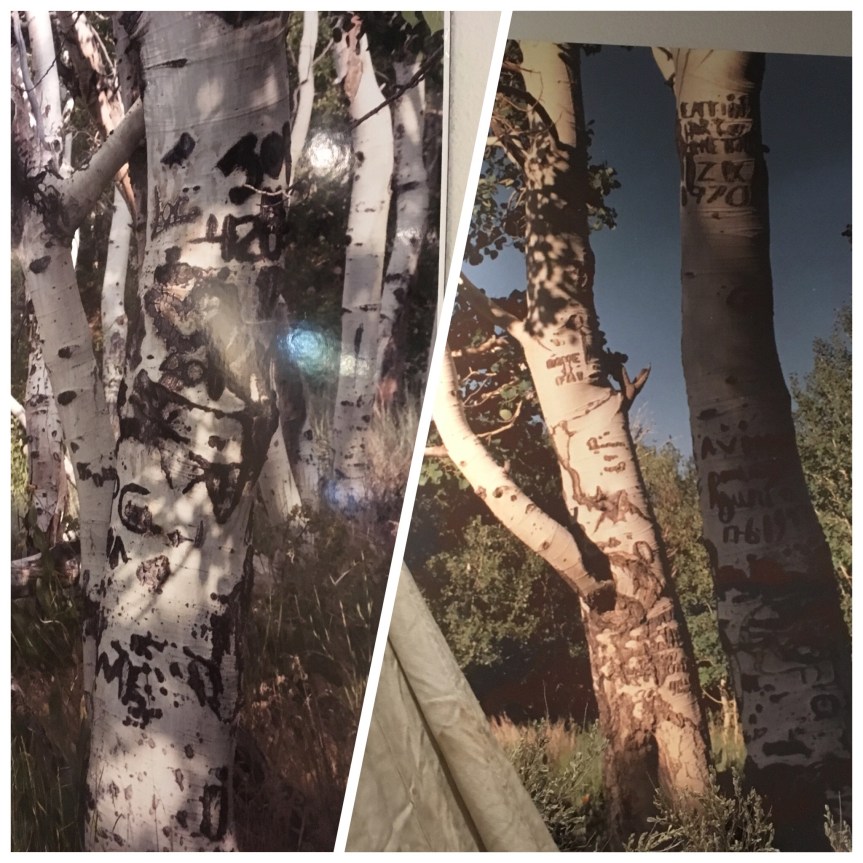
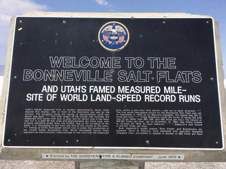
When I got there I was told that there was actually a race going on, and it would cost $20 to go out on to the salt flats… I told her I actually had to get back to the gas station because I had ordered lunch… and could I just take photos for now of the entrance way, and then come back after I had eaten (at which point I would pay to enter the area). She said yes, and directed me where to park.IMG_2372IMG_4629

After these photos I headed back to the cafe and had my lunch…. I also ordered a sweet lassi to drink with it.

IMG_4640

All of it was very tasty, but unfortunately the cook had undercooked the chicken thighs (my favorite part of the chicken too)… so he took it back in to have it cooked some more, and the chef for some reason opted to deep-fry it, meaning I still couldn’t eat it (not allowed deep-fried food).

And that’s when I suddenly had an urge to go to the bathroom (as in I really needed to poop all of a sudden). While there, for some reason…  I had the very bad luck of getting seriously sick. I was sitting on the toilet, pooping, and that black veil dropped in front of my eyes warning me that I was about to pass out. I put my head between my knees, started shaking and sweating really badly (as in heavy drops of sweat were falling off my forehead onto my glasses)… while sitting in what I knew was a cool room. I tried to stand up a few times and almost passed out each time, forcing me to sit again, and put my head right back between my knees… I tried pulling my pants up, but didn’t have the strength to do it. I was forced to ask a complete stranger to help me get my pants up. She, however, didn’t speak english; so, I asked her to please get someone who could — she spoke enough to understand that. It took her a while but she brought a guy from the shop, who translated to her what I wanted, while asking me if he should call 911, but warning me that the hospital was very far away and it could take them 20 minutes to get there. I told him not to. She helped me, and then I staggered over to the sinks and held on to them, still shaking horribly. She opened the faucets and started splashing my head with cool water, which actually helped.

When I started to feel a bit better I staggered over to the restaurant, paid my bill (poor guy must have thought I’d run out on it), sat at a table and put my head down on it and just stayed like that for about 20 minutes…. then with baby steps I got back to the car… guzzeled water I had there and waited for my head to clear so I could drive the almost 2 hour drive… I was actually pretty proud of myself all things considered

As such, I was only really able to glance at the salt flats before forced by illness to head directly towards my next hotel where I could rest … because to quote The Bard, “discretion is the better part of valor” —Henry IV, Part I, and while I am aware he meant it as a joke, I prefer its idiomatic usage, because it has a great deal of truth to it.