The personal authentic travels of a world-wide drifter, you'll always see pics of me at the locations being described (if the other blogs you're reading don't do that, odds are they were NEVER there, just saying…)
In October, while driving Route 66, I came across this marker/monument in Oklahoma. It denotes the eastern boundary of the Oklahoma Land run of 1889. For those who are unfamiliar with this event, it is yet another one of the many moments in American history where white men feel proud of themselves (there’s a HUGE monument to the event in downtown Oklahoma City), for essentially screwing over the indigenous red man who was there first (please note there is NO reference to them on this monument). HOWEVER, it also has something to do with the Case of Carpenter v. Murphy which is currently before the Supreme Court of the United States!
In fact the Run of ’89 was the first of a series of land rushes organized by the Federal Government. These were “organized (HAH!)” events where vast numbers of WHITE settlers, 50,000 of them in this case… lined up with a flags in their hands, and at the sound of a gun were supposed to surge across the UNASSIGNED countryside on horseback or in wagons, racing to outpace the other contestants, find a nice piece of desirable FREE land, drive their flags into said piece and thereby “stake their claim to it.” In reality, the gullible honest people did that… often to find cheaters (usually rich people who had illegally surveyed the land ahead of time) already there (along with all their employees) trying to make it look like they’d actually done the run along with the others… when they had not… and had somehow managed to grab all the best bits of land first. So this was not only White people screwing over Red people, it was also rich white dishonest people screwing honest hardworking poor white people.
Of course, all of this screwing was only possible after the government had “legally” screwed the folks who were already there…. the Native Americans…. Initially this was done via the Indian [land] Appropriation Acts where the government gave itself the right to yet again round up the local Native American population, this time to force them into reservations. When I say yet again, you need to keep in mind that the State name, Oklahoma, is derived from what it had been called at that time… i.e., the Oklahoma territory… and that the word Oklahoma is actually a composite of the Choctaw words “okla” and “humma,” which translates quite literally to “red people” … i.e., Red man’s territory.
This was an area that had at first been occupied by the Choctaw Nation (a multi-tribal people that spread from Oklahoma to Florida, and were united by a single language, Choctaw), who were then joined by the Cherokee… who were only there because they had already been moved once. Some came begrudgingly, as a result treaties they had signed, such as that of New Echota — the one made with the leaders of the former capitol of the Cherokee people( which I had visited twice, located about 1.5 hours from my friend home in Dalton, Georgia) with the Federal government; and if individual Cherokee refused to go by choice, they were FORCED to do so, on what later became known as The Trail of Tears. Ultimately, all of the Native Americans living within “Indian Territory” had been members of what the American colonists had referred to as the “Five Civilized Tribes“….Native Americans groups from along the southeast sections of America who had tried to get along with the invaders by going along; groups who had converted to Christianity, adopted centralized forms of government (see my posts about New Echota), were literate (see my post about Sequoyah), participated not just in trade but in the market economies of their areas, AND, to top it all off… OWNED SLAVES (see my post about Chief Vann, who maintained a plantation just north of Echota). All of these tactics of compromise ultimate failed, and now… having already been relocated to Indian Territory — which was supposed to be JUST for them… they were removed yet again, forced into reservations, and what had been their land, was now deemed “unassigned,” was given away to white people… who grabbed it in the mad rush described above.
And the bleeding of the tribal lands in Oklahoma has in fact continued to this day so that only 2% of what had been Cherokee Nation land is still under their own control. Now here’s the good news… AFTER I had already driven past this area, on November 27, 2018 the Supreme court heard a case called Carpenter v. Murphy that calls into question whether the tribes of the Five Civilized Nations STILL have sovereignty over its own people on lands that had sort of bled out of their control within the Indian Territory lands in last 100 years.
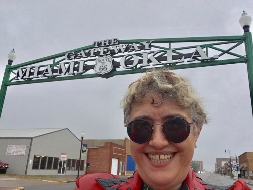
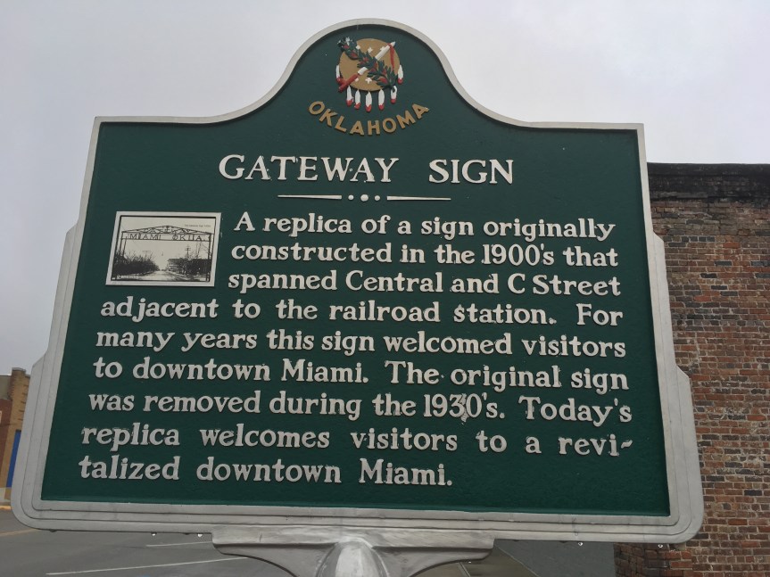
Just as you enter Miami Oklahoma you see this really nice Route 66 sign
The Miami in this case is not the Miami of Florida, rather it denotes the land that had been assigned to the Miami tribe, a people that had originally lived in what is now Indiana [where they are no longer recognized as a tribe] but were forcibly moved here when the white populations in Indiana wanted them gone. This relates to other places I’ve visited such as Tippecanoe Battlefield, where after the battle of the same name the Indians who had followed Tecumseh, were forced to move to here, to Oklahoma (i.e., which literally translates to Indian Territory — discussed in greater length on this blog post) while the ones who did not support him and had decided to live like white men were allowed to stay in Indiana.
The word Oklahoma actually translates in the Choctaw language to “red-person,” specifically, ukla=person and huma=red, and the entire territory had initially been ‘given’ by the US government as a territory intended solely for the tribes… and it is where the tribes from the southeastern states were marched towards on the Trail of Tears.
This Memorial located directly upon the old Route 66 route marks one of the boundaries of “Indian Territory” a continually shrinking zone that the American government promised to leave to its native populations that at this point is more easily observable via the names of places than on the faces of its occupants.
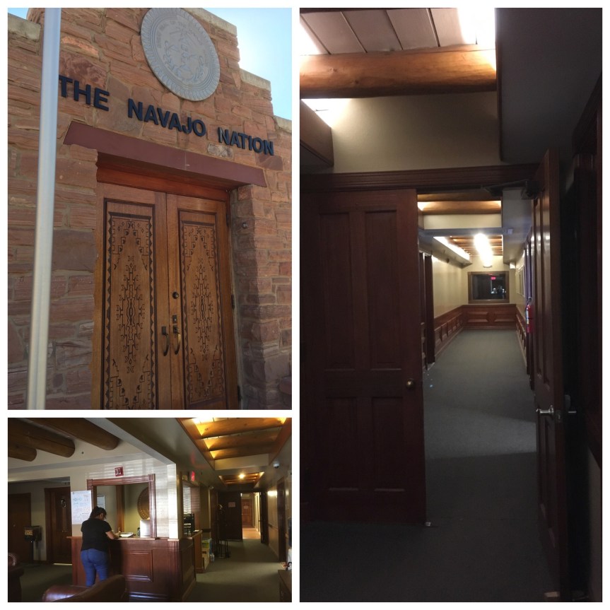
One of the Native American Reservations that Route 66 passes though is the Navajo Nation. This rock formation (known in Navajo as: tségháhoodzání or, the rock-with-hole-through-it), lies the city’s Memorial Navajo Tribal park, and it is what gave Window Rock, Arizona, the nation’s capitol city, its name.
In the park there is a stature dedicated to the tribe’s veterans (Native Americans take their citizenship and military service VERY seriously — as part of being modern-day warriors) and in particular the statue commemorates the NavajoCode talkers who were instrumental during WWII.
Adjacent to the park are MOST of the buildings that constitute the government of the Navajo Nation.
For those who don’t know, the tribes are Dependent Sovereigns with the right to govern themselves, to a point (and that point has varied). This part of the town is where you’ll find the Navajo Nation’s Counsel Chambers,
The offices of President and Vice President
the tribal courts (Each tribal nation has its own Supreme and District courts), and the central location for the Nation’s police force (tribes are controlled by Federal laws but not State).
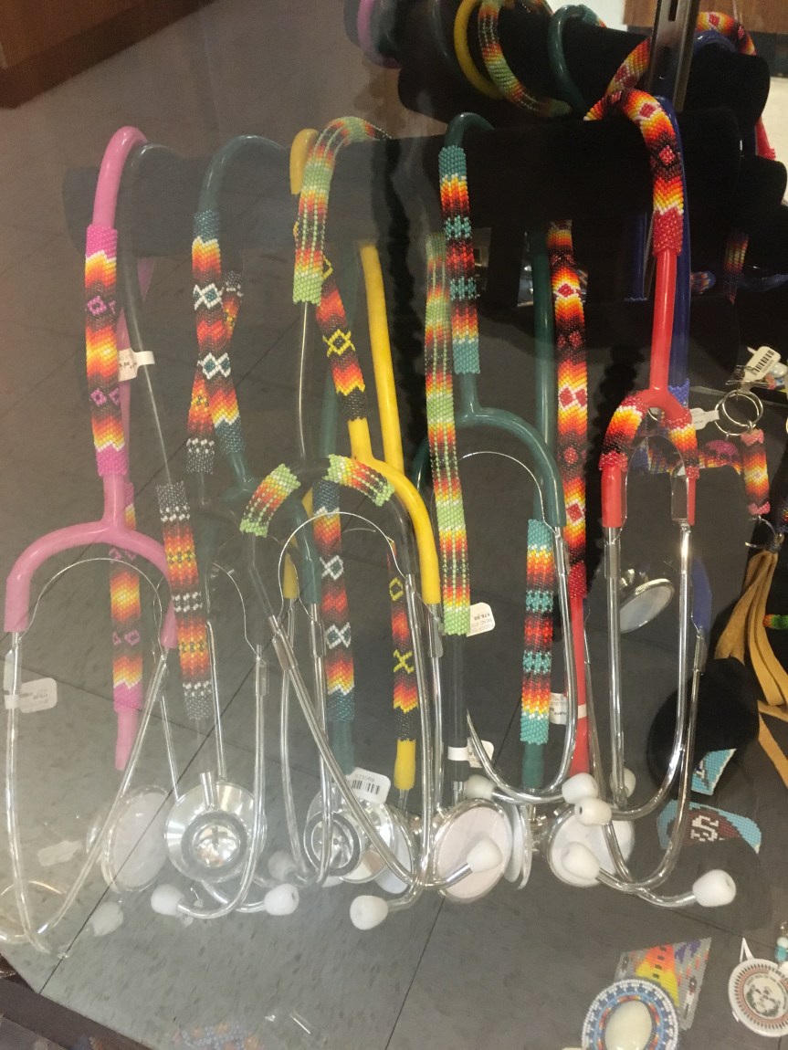
The Navajo Arts and Crafts Enterprise is located in Window Rock, Arizona, and is for anyone visiting the Southwest in search of Native American Jewelry who gives a shit about their rights and/or disenfranchisement …and all that good shit.
This is a store run by the Navajo nation that sells the work of some of their best artists– who are insured proper payment for said work. In other words, this is NOT where you come to get the “best prices” (which are often obtained by taking advantage of artists who don’t under stand pricing) but rather some of the best work, guilt free. Everything from jewelry to Navajo rugs, all of the highest quality … where you know for sure it was made by a Navajo and with the best locally sourced stores and wool, etc. (no Chinese crap pretending to be Navajo, etc.)
If I had a friend who was a Native American Doctor or nurse, I’d buy this for them
The Store also sells Navajo raw products (locally mined stones, wool, etc.) to other Navajo looking to turn them into products for sale to the public.
They’ve gotten much bigger and much more bureaucratic/professional since i was last here (20 odd yeas ago). In the building they used to not only sell stuff but also have workmen on staff who could repair it for you on the spot. Now they’ve got a second building mile away where they do storage and they keep the repair men hidden away, and you have to drop off and wait a week or so to get the repairs done.
I had been saving up some stuff I needed fixed for when I next passed through the area, but it appears that was for naught. I even went to the second building hoping I could find somebody who would fix my ring ASAP, as I was only in town for two days… but they said they don’t do that anymore
The Hermitage is the home of Andrew Jackson, America’s seventh (from 1829 to 1837, he served two terms) President of the United States, and possibly one of our most controversial ones. To put it in a modern context, Trump is a big fan of Andrew Jackson, and a lot of people compare the two Presidents as being similar, and will view that similarity with the same intensity of love and or hate for the man, depending on their political leanings.
How people viewed President Jackson is part and parcel with the nicknames they gave him. So for instance his names among the whites varied from “Old Hickory” which was given to him by the soldiers who served under him and loved him, to “The Hero of New Orleans,” because of his successes in the Battles for New Orleans (December 14, 1814 and January 18, 1815) as part of the War of 1812, notably his wins happened AFTER the treaty ending the war had already been signed (December 24, 1814), but apparently that didn’t (and still doesn’t) matter in the minds of his supporters … to “King Mob,” by his white detractors, because his most avid supporters for position of President were considered the illiterate mob. While the names the Native-Americans gave him included “Sharp Knife,” given to him by the Muscogee/Creek people, or his even more explicit Cherokee name of “Indian Killer.”
So for instance, during my travels I’ve spoken about the Trail of Tears in numerous posts, and that act of genocide was initiated by the state of Georgia, but could never have happened but for Jackson’s who hearted support … His supporters (current day hard core republicans) will often point to his high respect for the constitution, and how he said, “The Constitution and the laws are supreme and the Union indissoluble” when speaking against a state’s right to secede from the union, but seem to completely forget that the Cherokee had fought their forced relocation by the state of Georgia all the way to the Supreme Court and won their case, only to have Jackson, who had as part of his campaign promised to support Indian removal (the same way Trump has promised to kick out illegal aliens and build the wall) completely reject the court’s findings, “supposedly” saying (but probably didn’t) “John Marshall has made his decision; now let him enforce it!” and then instructing the US military to forcibly remove the Cherokee anyway.
And yet, Andrew Jackson was a man of the people. In a government that had till then been run almost exclusively by men from America’s “best families,” essentially our upper classes … Jackson was quite the opposite. Without him Lincoln might have never been elected. The illiterate and unwashed populace supported him because he was one of them, hence the title “King Mob.” And even some of our most iconic liberal media TV shows, like The West Wing, are therefore forced to tip their hat to him.
My first visit to the Hermitage was in December of 2010, and there was snow on the ground. To be honest my desire to come here again was so I could blog about it here as part of my visiting sites around America related to our Presidents and First Spouses (in fact I’ll be doing more Lincoln stuff in a few days) and to see if there were any changes to the place. And there had been, although nothing particularly substantive.
When you first enter the property, you are now given a choice between two different sorts of tickets. The major difference being, one includes the older audio device for self guided tours (audio, but no pictures), while the new one includes a sort of smart phone like device, which adds images, a few more narrations with more information (much of it about relationship between Jackson and his slaves), and a 10% discount at the store which I wish they had actually told me about when I paid for the thing, because I bought about $80 worth of costume jewelry while there and that $8 discount would have paid for itself (I only just discovered it now).
In the photo on the bottom left you can see a staff member demonstrating how to use the older audio device (on the wall behind her were the three sorts of tours information), while on the bottom right is one of the new smart-phone type machines, which is what I was using. Regarding the sorts of information offered, I found two things interesting: firstly, On adult devices do NOT allow you to hear the blue 200 series audio files, intended for kids, so that as a parent you can’t actually know what they’re telling your kids, or NOT telling them… that’s a problem! Also, if you think about it for a second, you get the feeling that the 300 series, the information about Andrew Jackson’s wife was added as an afterthought … as part of the whole, we need to pay as much attention to the first spouses as to the presidents movement.
After getting your headsets, or before, depending on how you time things, there’s short movie that provided a fairly level introduction to who Jackson was, pointing out that he could be mild-mannered and polite, as long as you didn’t get in the way of anything he wanted, in which case he could turn extremely violent, and you were essentially dog meat. (There’s a world for this, its psychopath … no I don’t have an opinion about this, why do you ask?)
After the movie there is a small museum area you can either walk straight through on your way to see Hermitage, or you can stop and appreciate, which will teach you more about the man and his importance to American history.
After the museum you begin to the approach the property, and this is when the audio aides come into use.
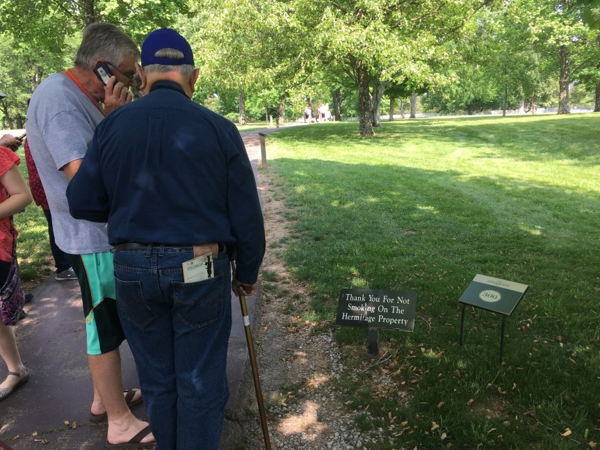
All along the path there are detailed signs you are meant to stop and read that offer other information (not available in the audio segments)
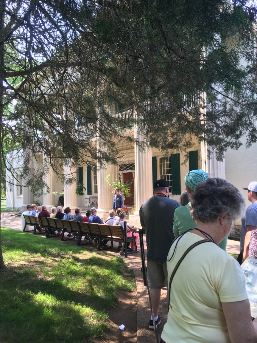
And then after you’ve walked a short but winding path you begin to approach the building itself, and are offered information about its building and evolution over the years before, during and after Jackson’s presidency.
Then, you stand in a cordoned off line, and wait for your turn to enter the building. For this they’ve come up with really smart way of breaking the tourists into easily manageable groups. There is a set of benches, and only as many people as can comfortably sit on the benches at once are allowed in at a time, and each group once seated is given a short speech about what they’re about to see, with a question period after it, all of this intended to space the groups out.
One difference I DID notice between this time and my previous visit in 2010 was back then ALL the various tour guides were dressed in period costumes, while this time they all were wearing modern clothes. (I think this change is a loss)
Note the difference in cloths of this guy (in the black outfit) in this picture taken in 2010 with the young guy in the picture taken yesterday
Additionally, and this I’m less sure of, last time I’m pretty sure that the same docent stayed with our group along the whole tour, while this time we visitors were moved from one location to the next but the tour guides stayed put.
Both times, while in the house, we were not allowed to take pictures. However, I think this was for two reasons, firstly, picture takers can slow down the efficient movement of people from one location to the next, and secondly, picture takes tend to break the rules in favor of a good shot… crossing boundaries and using flash (which could have a cumulatively destructive effect on the antiques in the house).
But once you’re outside of the shuffled through tour part, there’s not only no one telling you NOT to take pictures, but there also plastic walls in place separating you from any chance to do anything destructive… via the servants section of the house where you can see into the main house … so… here are some.
This was the informal part of Jackson Parlor. In the Front rooms, which are not directly visible from the servants area is where he met official visitors, this back room was where family would spend their time
This is the dining room. The flooring which looks like linoleum is actually a waxed cloth (like wall paper for floors) that was popular at the time and even existed in the White House. The stove was a modern Franklin stove which was much more efficient than a fireplace.
The home would house any and all visitors who came that day (as at that time it was a couple of hours ride away from Nashville), offering them a place for the night. Bed rooms were filled on a first come first serve basis, separated by gender, with late comers given bedding on the floor, as was the common courtesy of the day. (There’s actually an amusing story of one time Thomas Jefferson while running for President went to visit the then widowed Martha Washington in Mount Vernon, and she hated him so much while she could not refuse to see him, she did not, as was considered common courtesy, offer him a place for the night… and he was forced to ride all the way back to Alexandria. A MAJOR diss… we know this is true because apparently he ran up quite the liquor bill that night at the inn he ended up in)
After dinner, the dinner table was designed to be easily taken apart, and the dinning room was then available for dancing and other entertainments. Right behind the dining room is of course the servants area, such as the kitchen and store rooms
Another change I noticed was, while last time I was here, people would press the various buttons (like the one here in front of the kitchen) to listen to the recording describing the area, which was blared over a loud-speaker to the whole group at once, this time NO ONE (other than me) pressed these buttons. In fact I spotted one woman bitching to a guard that I had disturbed her by doing it… to which I’m pretty sure he responded, “Madam, that’s what they’re there for.”
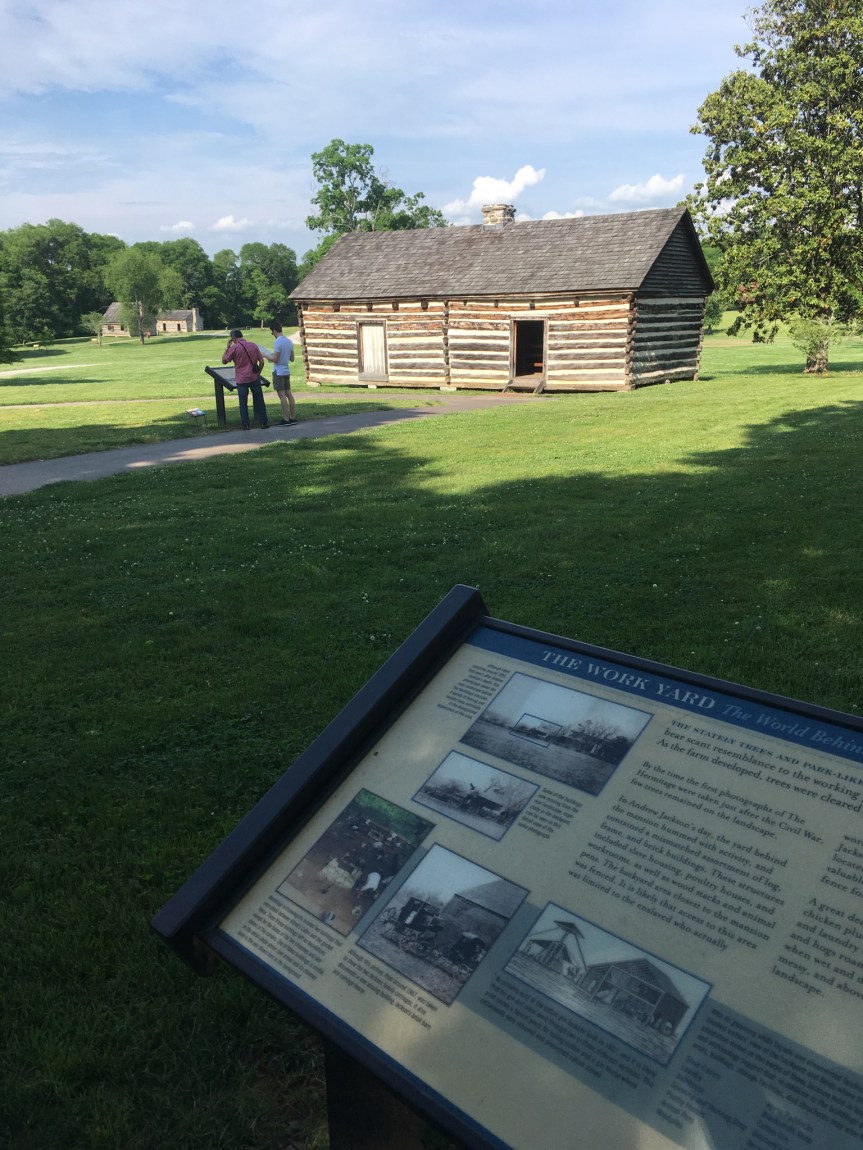
After the house you walk to the fields, work houses and slave quarters that are located in the backyard area
A view of the house from the back, less fancy than from the front
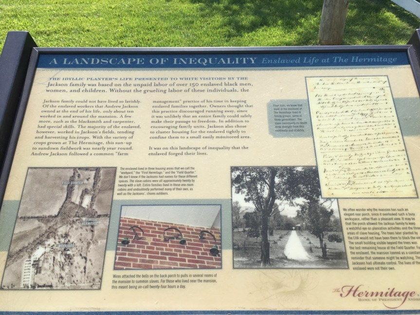
One of the interesting things that I learned was that while one of the horrors of slavery you always hear about is families being separated, it was NOT Andrew Jackson’s practice to do this. Whenever possible he kept slave families together even to the point of it not being economically practical (holding on to the very young and the very old), to the extent of he once purchased a seamstress for his time at the white house, and then upon her request her whole family… she had informed him that they were all trained house slaves owned by a man going bankrupt and therefore at risk of being seperated (it was in one of the audio files, from her voice I think she was the same African-American historian who spoke in the movie, who specialized in the slave experience). However, according to the above sign, Jefferson did this less out of the goodness of his heart than as a modern slave management technique, designed to make slaves less likely to want to run away as the larger their families, the less likely they would be able to do it together.
That said, back when I was studying the institution of slavery at Northwestern University with a professor who specialized in it, one of the things she taught us was one of the best measures of was, and I preface this by saying slavery is a HORRIBLE thing and should never exist, and there are therefore no “good” slave owners… that said, the way to distinguish the relatively ‘good’ owners from the really bad ones was once emancipation came, how many freed slaves chose to stay put and continue working for their former owners, versus opted to grab their freedom and pursue better options. The reality, as politically incorrect as this might sound, was that many former slaves stayed put (or came back after doing a walk about to see what else was out there)… but those owned by BAD owners, the ones who were most notorious for their evil behaviors… those saw their “families” of former slaves abandon them with a will…
That said, while Andrew Jackson had passed away about 20 years before the Civil war, and it was his son who was the owner of all of his former ‘properties’ once emancipation came to the Hermitage, according to the sign above … most of Jackson’s “black family still at the Hermitage chose an uncertain future and fled behind Union lines”
In fact, I wasn’t able to find the sign this time, but I remember that last time I was there I read one that said in fact almost ALL the former slaves but a small handful (I think the number was like three?) had run away from them, telling you pretty much everything you needed to know, at least about how Jackson’s son had treated them.
This was my second visit to the New Echota historical site. A memorial to, and attempted recreation of, the former capitol of the Cherokee nation — a city that was modern for it’s time …. until it’s people were uprooted and moved west during the trail of tears — one of the more disturbing events in US history — even after they had fought their case all the way to the Supreme court (at the time headed by John Marshall) and WON their case, to which President Andrew Jackson replied:
My first visit was by myself in 2016, this time I was touring around my childhood best friend (who has joined me previously in my travels, but only ever for a few days at a time, in: Victoria, Washington D.C. and DisneyWorld; usually we’ll go to do a High-Tea together when she visits, but this time I wasn’t able to find a good one nearby). She had asked if she could visit me wherever I was going to be in March… at which time I was planning on staying not at an Airbnb, but at the home of another old friend who lives in Dalton (I said, “you can, but you’re going to have to find someplace else to stay”).
As such, since this is a second visit… I’m not going to repeat what I wrote then, but rather focus on any updates and or changes I find interesting or relevant.
As I commented last time I was here, “while I’m glad they built/are building this place, and I doubt it’s much of a money-maker… I question the motives that created it as much as I appreciate the results.” So, … it’s been two years… what’s new you ask? Not much. There was evidence of some construction/repairs going on at the front entrance/ roadway, but even though the last time I was there they said they were going to add to the “reconstructed” homes of the town, I didn’t see ANY evidence of said additional homes being built.
Picture from last my 2016 visit, the area was JUST as empty in 2018….. except for more grass
That said, there seems to have been cuts to their budget, as evidenced by not only the lack of developing the property, but also they are now selectively mowing the lawns, rather than doing it regularly and completely (like in the picture above from 2016)
Rather than mowing all the lawn, they’re just clearing paths
… and in the age of a high risk of catching Lime disease (which has serious derailed a few of my friends lives, one of whom used to be a researcher for NASA and now can’t hold down a job) from something as simple as a SINGLE tick bite, that’s a MAJOR issue
Please note the OLD picture on the left, the lawn was mown all the way out to the far trees, while in the most recent photo (on the right) they are only mowing the most high traffic areas and cutting some narrow paths for people to walk on. This is a problem because, to quote this website: “Ticks are attracted to areas with tall grass, moisture, and shade, so keep your grass cut short, your shrubs trimmed and your leaves raked up.” The first things I asked the park staff member when we were paying our entrance fee was how bad the ticks were in the park were… she responded that just yesterday she had pulled three of them off her body, and she didn’t remember going into the deeply wooded areas that day, i.e., she probably got it just by walking through the unmown lawns.
Last time I talked about how one of the coolest elements was they had created a narrated walking tour that you could call up with your phone, or by scanning the QR code with an application in your smart phone. What I hadn’t mentioned at the time was that you of course had to do it with your phone, and the free WiFi that is in the building (and insanely slow) does not extend outside of the that build’s four walls. As such, you’re reliant on your phone’s data signal to be able access it… and on while it had worked relatively well the first time I was there, this time… not so much. That said, the grounds are small enough, that it would be relatively easy and inexpensive to create free WiFi that covered that grounds… again, hasn’t happened (as I noted in my update on Ruby Falls, which is located about a half hour drive away, they HAVE wired all the caves for free WiFi).
The first time I was here I commented about how “What I would have liked to see but didn’t (which does not mean it isn’t happening, just that it wasn’t front and center in the museum) evidence that tribal elders are somehow involved in this site, etc.” Again, I really didn’t see much of that. However, one thing I noticed (it wasn’t new, but last time I didn’t really notice it) was this one hand cranked device that included descriptions voiced by individuals with distinctly Native American accents… that said, it would be SO easy to attach a solar panel to this…. cranking it was kind of a pain (we ultimately figured out you can crank it slowly).
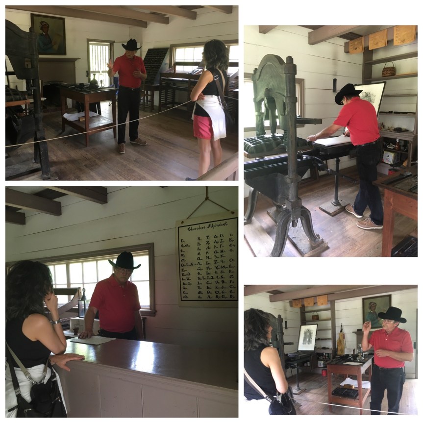
So, not only did the Cherokee have their own democratic government systems, but they also had their own newspaper called the Cherokee Phoenix (written half in English and half in the Cherokeelanguage) edited initially by Elias Boudinot (the paper is still active) which had a world-wide distribution (according to the docent), and literacy level among their people that was actually was higher than among the surrounding white communities (but at the time that wasn’t all that hard to achieve).”
Another difference I noticed between the two visits was when visiting the Print shop, which in my mind is probably the highlight of the who park; last time, visitors were allowed full access to the print shop to the extent that children and parents were even allowed try their hand at using the printing machine (under supervision)
This time, we were kept firmly behind various barriers (one being a rope extended across the work space), even thought there were only two of us, both adults. And when the guy printed something he did not ask us if we wanted to try our hand.
That said, I did learn a bunch of interesting printing related fact from him, a collection of everyday phrases that were inspired by printing,
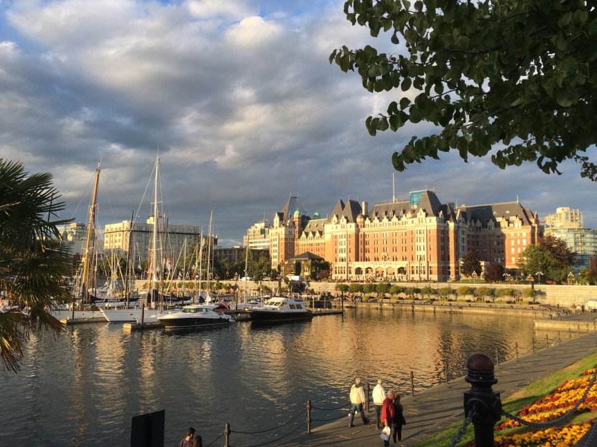
I spent a full month living in Victoria, a popular port-of-call for cruise ships, and liked it so much that it is now on my list of favorite cities on the planet (and I’ve been to most of the good ones) … so much so that I could almost see retiring there, if the Canadian Government would allow it.
So … as an explaination of WHY I like it much, let’s start with with a seemingly insignificant fact ….. no bugs — seriously! And this lack of annoying little critters extends to all of the Island, not just British Columbia‘s capitol city, Victoria.
One of the seemingly infinate pieces of outdoor art to be found along the streets of Victoria
Now, granted, of course there are bugs, there wouldn’t be life if there were not bugs… but not so much that you’d notice; and more to the point, other than chiggers (out in the woods) not much in the way of bugs that bite. I was on Vancouver Island for two whole months and only suffered ONE … seriously… ONE mosquito bite. And it really doesn’t seem to matter what time of day we’re talking about. Granted this may seem trivial, but after having spent a few months in places like Florida or parts of the upper midwest — where you’ll be eaten alive at certain times of day; and when you are bitten you run the risk of things like zika and other nasties … 24 hours a day; and let’s not forget to mention myriad places on the North American continent where if you drive at dusk, within miniutes your car will become so THICK with dead bugs that you’ll have to get it washed, and the job will HAVE to be by hand, or you won’t to get rid of them all (and if you don’t … you’ll have the pleasure of watching other bugs swarm your car to feast on the carcasses of their dead friends. So, really, you learn to appreciate ‘no bugs.’
Beyond that, let my list the other reasons why I love Victoria so much:
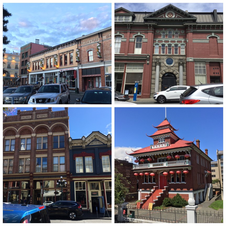
Architecture
As my pictures will show, it is a visually GORGEOUS city; the local government has put laws into place that require that all historical buildings be maintained (at the very least their facades) and/or restored. The result is panoply of colors and designs to delight the eyes. Architectually it’s buildings range from Stuart influenced Victorian British and early 19th century Americana, to a smattering of modern glass and steel on the outer edges of town.
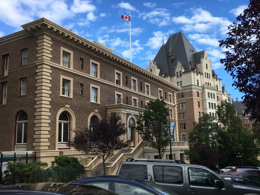
This is the capitol building for British Columbia
The red pagoda looking building is a school that serves the Chinatown community
History:
Victoria it is a city that with British zeal embraces and honors it’s history in a myriad a ways; if you pay attention, stop, look and read, you almost don’t need a tour guide to learn about the place; and it’s not allways done via obvious things, like this memorial to Captain Cook,
The plaque below it reads:
Capt. James Cook, R. N. (1728 – 1779)
“After two historic voyages to the South Pacific Ocean, Cook was cruising the waters of the Pacific Northwest on his third and final voyage, with his two ships, Resolution and Discovery. He was searching for the western exit to the legendary Northwest Passage. In March 1778, they put into Nootka Sound for repairs and to trade with the native people. With him on the voyage were Mr. William Bligh as master of the Resolution and midshipman George Vancouver.
This statue was commissioned by the Victoria Environmental Enhancement Foundation and unveiled by The Honourable William Richards Bennett, premier of the province of British Columbia. July 12, 1976.”
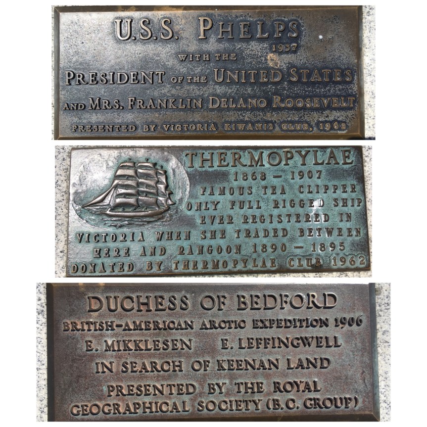
Rather, in Victoria you really need to pay attention and look, because the place is RICH with historical documentation, but it tends to go overlooks; for instance, one of the things I noticed (during my month long stay in Victoria where I passed this statue almost daily) was that MOST tourists never seem to stop and take notice of is the LONG line of smaller plaques all along the wall located right behind that statue (see picture above), and all along the dock which memorialize all the notable ships that docked in her port (below are just a few example, but they line the whole dockside):
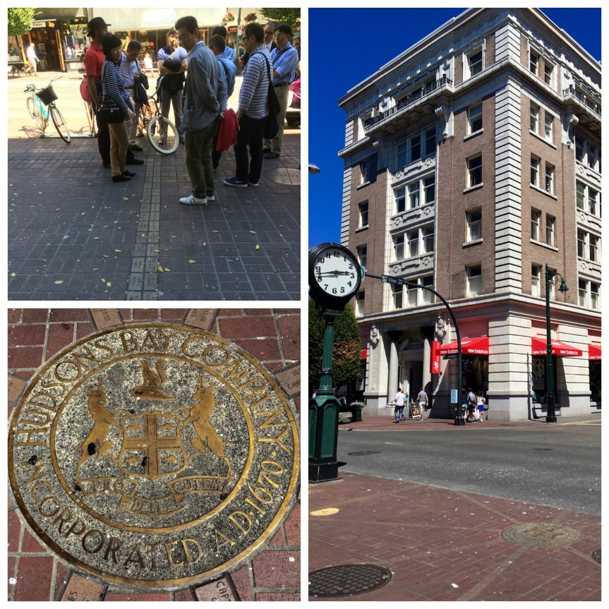
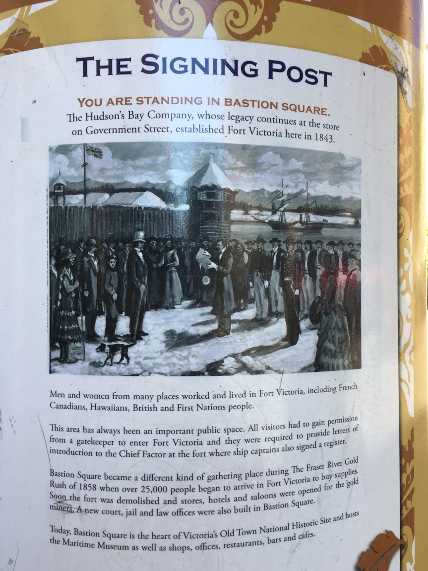
Another example is that there is ample evidence and explaination regarding the location of the original fort on the main shopping street in Victoria, but if you don’t stop and look (as the Asian tourists who were being led by a professional guide — the guy in the red shirt — are doing in the picture below) … you’ll miss it:
The large tan and white building, across from where the fort had stood, was the first office building of the Hudson Bay Company, when Victoria transitioned from a fort to a cityEvery name memorialized in these bricks is that of a founding citizen of the city
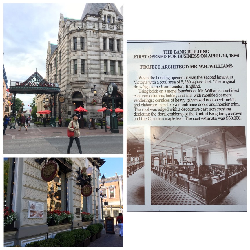
And then every single historic building that’s been renovated and repurposed (and there are LOADS of them) has attached to it a sign explaining the history of the building. Below for instance is a bank building that is now a bar.
And then Victoria has different districts, and again, if you stop and look you’ll find plaques, and the like, explaining the area’s past.
And then in the front of the Government building, there are little vignettes, describing the history of the city, performed by the Parlimentary Player’s, a group of young actors dressed in historiacal garb that try to ‘bring history to life’ in a way that might be more appealing for those who don’t enjoy reading — including one playing the role of Queen Victoria herself. After which, you can enjoy a enjoy a tour of building itself (either self guided with a pamphlet, or led — for a fee, see my blog post).
That said, it is STILL worth your while to invest in one of the many historically themed walking tours, because they will often add more information than the signs and plaques, not to mention point out little historical tidbits that city has overlooked — or chosen not to — document… for instance, as you walk along Fan Tan Alley in Victoria’s China town you might easily walk right by this little piece of history which links back to the active opium trade that used to exist in the area.
What the picture doesn’t show (or at least well) is that across the alley from the door are two peep holes in the opposite wall. From here, guards would check the alley for cops, and if they gave the all clear, the metal door would open, handing a customer his or her opium.
In addition to the history that exists in historic parts of town, There are more historical spots, just on the outskirts like the Fort Rodd Hill National Historic Site (see my blog about it), which host historical events, Craigdarroch Castle (again, see blog), and Christ Church (ditto).
Public Art:
Public Art is visible almost everywhere you look; be it street art, murals (government sanctioned or otherwise) that either celebrate the city’s history and rich cultural past — or simply decorate boring buildings, sculptures that range from monuments to famous people involved with the city’s history, to the more esoteric and fanciful, Victoria almost doubles as an outdoor museum.
Mother Nature, Natural beauty:
Although one could argue that Victoria’s proximity to the ocean is such an incredible an asset, that the aforementioned, massive investment in public art, is “gilding the lily” just a bit …
And in addition not only have the Canadians inherited the British love of gardens, but they the almost perfect weather for a wide variety of flowers and plants. The weather is SO good (not too hot, not to cold), that it is considered to have a mediteranian climate (PALM TREES growing outdoors, north of Seattle, REALLY!).
To that effect, a short drive away (maybe 20 minutes) is the world famous (see my blog post on) Butchart Gardens, which not only hosts musical events, but also serves up a very nice afternoon tea
Shopping:
I was really impressed by the shopping in Victoria. The prices for pretty much everything are low (well, at the exchange rate at the time, that could change); And there is great shopping from high fashion to antiques;
A bank, converted into a book store
The guy who owned this store, which was stocked with stuff that made my history major heart swoon, said that he USED to have significantly more WWII era stuff, but that the Holocaust Museum in Washington D.C. bought out most of his best items a few years ago.
This next store was probably the coolest of of the MANY gaming stores I found in Victoria, as in one every few blocks — apparently gaming is a popular activity there. You could come with friends, or join up with other folks already there, play board games, etc., and buy them if you enjoyed them… plus it was a cafe.
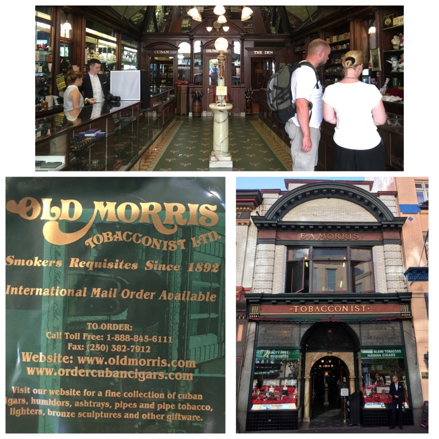
The owner of this next, historic store, which is the oldest contiuously running store in the city, said he was worried now that US and Cuban relations were about to normalize, as a large chunk of his business was selling Cuban cigars to Americans tourists who couldn’t get them at home.
Once many years ago, while in the UK, I accidentally purchased a t-shirt made of hemp, found it to be an amazingly comfortable, sturdy, and breathable fabric, and have been looking for clothes made of it ever since; hemp clothing was difficult to find in the US, till quite recently, because of it being a variety of cannabis plant, i.e., marijuana).
So when I saw this store, I got excited; Now, granted, there wasn’t much I could buy — since living out of the trunk of a car limits one’s closet space, but since I was supposed to attend the orthodox Jewish wedding of an old friend a month later, and didn’t have anything appropriate to wear, I had a reasonable excuse to buy myself a really nice formal (yet informal) dress made from hemp.
Safe!:
From the perspective of a girl from Chicago, Victoria has an impressively low crime rate (see happy homeless people for part of why that is) so that as a single woman I felt completely comfortable walking around alone, even at night;
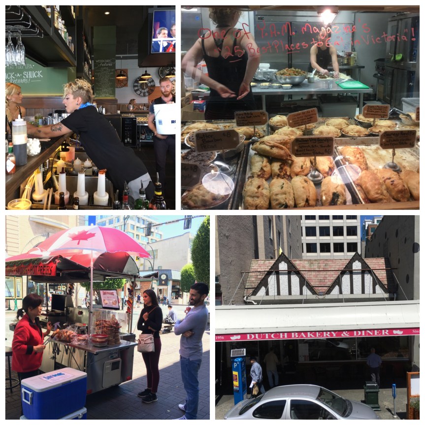
Great resturants:
There are no shortage of really great resturants, (see the blog post about my favorite, the Ferris Grill) all of which have fresh from the ocean seafood obtained from the local, and more importantly working, (see my blog post about) Fisherman’s warf; so that I got spoiled with buck-a-shuck amazingly fresh oysters, most of which were HUGE… and then keep in mind the exchange rate, so that from my viewpoint it was actually cheaper than $1 each. While there is a China town, I was not overly impressed with the Chinese.
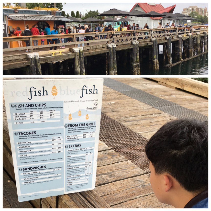
RedFish BlueFish is a VERY popular foodstand on the dock across from the fancy hotel (not fisherman’s warf)
Music and Art:
There is an active music and arts scene! (Although, sadly, not much in the way of Theater) For instance, there are free concerts almost every week day in front of the city hall, not to mention orchestral presentations at the local cathederal, and a plethera of street performers.
Tourism:
From a straight tourism point of view, there’s relatively little in the way of “tourist trap” attractions (which is not necessarily a bad thing). There’s the aforementioned fisherman’s warf area, there is one really good museum (see my post about the Royal British Columbia Museum) which hosts really impressive traveling exhibits, and a few small ones. There are also in addition to the aforementioned historically themed walking tours a few tour different bus tour companies, whose offerings are for the most part, the same (I took two of them).
of the multiple tours the most amusing one I spoted (although not for me as I don’t drink) was the rolling pub tour.
And, as a Jew, I was very excited to see an active Jewish community (albiet a tiny one) that was active in the city
On the road to it I passed what at first I thought was just a bunch of cattle, but then when I got closer I realized they’re not cattle, but rather were buffalo –
– later I wondered if they were the same herd that provided the meat I was eating at the site’s cafeteria — bannock is apparently the name here for the chunk of Indian fry-bread like stuff that came with the Buffalo Stew
There seem to be two major variety of tourists to this place, firstly, the hikers, who tend to take the interpretive trail to the bottom of the drop, which is about a mile round trip
And secondly, folks like me who are not so much for the hiking or the running into mountain lions. For us there’s a van that does continuous round trips from the parking lot at the bottom of the hill to the visitor center at the top (really NOT that hard of a walk, but I’m no fan of hills). Then you walk into the visitor center and take two elevators up to the top, where you walk up a gentle slope to the top of a fenced in area on top of the hill for looking down.
This area is paved, fenced in, maybe a 3 minute walk, wheel chair accessible, and ends in a small plaza with benches and telescopes, and a fabulous view of the plaines below — way more my speed.
At the end is the buffalo jump, a ragged cliff that the animals were stampeded over as a hunting technique. According to the information provided, there’s scientific evidence that the cliff was used for that purpose as early as 5,500 year ago. Hunters who were young and good runners would dress up as wolves, pursuing the buffalo, while other members of the tribe would have prepped the ground with rocks and branches, so that the buffalo, who apparently have lousy peripheral vision, would think they were walled in, and run where the hunters wanted them to go — over the edge.
According to the signs, back then, the sandstone cliff was even higher up, and has actually been worn away both by the weather, and the repeated stampedes (sandstone being very soft).
Also, the name derives not from the buffalo, but from a native American story about how one time a native boy, not willing to listen to his elders, had hid at the base of the cliff hoping to see the animals fall, and they had fallen right on his head. When his parents found his, his head had been smashed in.
While I did not see any large wild animals while I was there, I did notice this little guy — a sort of yellow ground hog — who was hanging out on the far edge of the rock (which he sort of blends with — camouflage) just hanging out and enjoying the view along with the humans, but as far from us as he could get (there’s a fence that kept me from getting any closer).
Back inside the building is a visitors center (designed so that you see this AFTER viewing the outdoor cliff view), that explains the history of the location with a multimedia display, museum exhibits of items excavated from the area, a fifteen minute movie where local indians (actors) re-enact the hunting techniques of their ancestors, the aforementioned cafeteria and of course a gift shop.
One of the things I found interesting, if a tad disturbing, was the how they specifically tried to hunt in early spring, even though that is when they thinnest — less meaty — in order to be able to kill the buffalo when there were likely to be new born calfs (veal if you will) and the pregnant mothers with unborn babies whose skin (calfskin) was used for things like babies blankets, etc.
According to the museum exhibit, there used to be a lot more of these sites scattered around the plaines, with massive piles of buffalo bones, but between WWI and WWII they were decimated by industrial firms who wanted them for their phosphorus content which was used in explosives and fertilizer. One of the only reasons this particular site survived that process was because it was so far from any rail lines and/or farms, that it was not cost efficient to plunder.
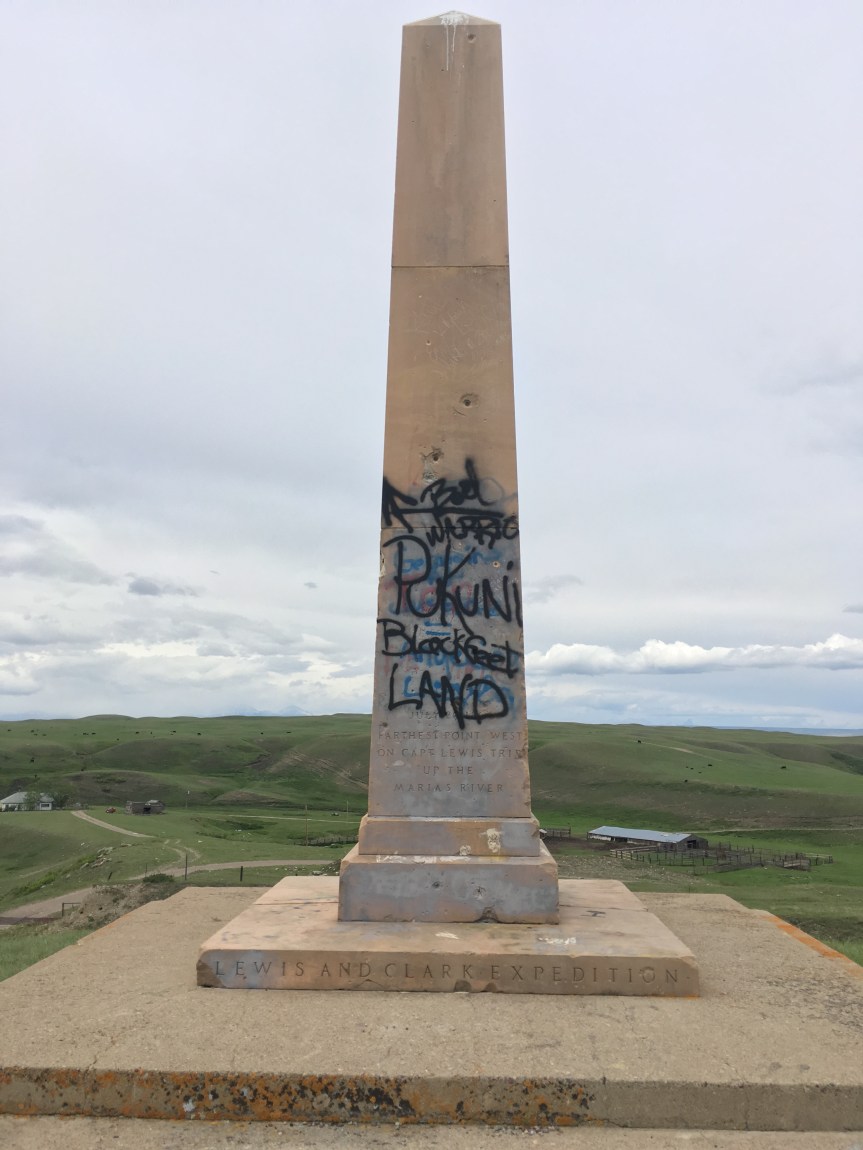
Situated along the return route of the Lewis and Clark National Historic Trail, this site is very near another, more historically significant, site that marks the northernmost point on their trip on the same Marias river known as Camp Disappointment (reason explained at this other blog I wrote)…. an event that happened there explains why this monument is so heavily graffitied.
I passed this ‘monument on a hill’ as I was driving at 80mph (the speed limit) towards Glacier National Park. I stopped, backed up the car (happily there wasn’t much traffic on that road), and took the barely marked, pot holed, uncared for gravel path up to it — worrying about possibly needing to get my tires re-aligned after, or worse getting a flat. Once I got up there, and not yet knowing the context behind its defacement, let’s just say I wasn’t happy about what I saw. But here’s what the whole thing is about.
Back at the National Park’s Lewis and Clark Center, in Great Falls, MT., I had learned how, on their way back to see President Jefferson, after trying to find a tributary of the Missouri river that would travel across the 50th parrallel Captain Lewis’s portion of the expedition met up with a group of eight young Pikuni“Blackfeet” warriors on July 26 on his way back from Camp Disappointment to meet up with Clark’s half of the group. After Lewis’s group met this group of Blackfeet, they had sat down to a friendly dinner, that apparently had a included a foot race and some friendly gambling. This is where the agreement among whites and Blackfeet diverges with regards to what happened next.
The next morning the “braves” (whom Native Americans argue were just young boys), are said to have tried to steal the expedition group’s rifles (at least according to Lewis’s men). A fight broke out and two of the Pikuni were killed in the only violent encounter with any native Americans during the whole expedition, part of whose goal was to open up trade and good relations with any tribes they might meet. This incident, however, had the opposite result, with the Blackfeet closing off their territory to whites for the next 80 years — till it was opened again by force. And then, to add insult to injury, from their perspective, Blackfeet became one of the ‘go-to’ tribes (along with others, like the Pawnee) for “bad/violent tribes” in American myth and movies.
As such, what happened to the monument was not just wanton destruction (although it is) but rather is evidence of the repercussions of an historic event (albeit one not described on the monument) that to most of the Anglo population of America is just a footnote in history, but to the Blackfeet is a source of constant grievance regarding how they are displayed in the historical narrative of America.
I think it is highly relevant that I learned all of this NOT at the visitors center, but rather later, after mentioning to a professor I met near Glacier National Park about what had been done to this monument. He was the one that told me that the Blackfeet tribal members are STILL seriously pissed off about this incident and blame it completely on the “invaders”.
That said, I will note that on the American side there is a single interpretation of what happened, while on the Blackfeet side there are multiple and conflicting ones, with one story saying that during it was there had been gambling and racing and that the warriors were in fact boys who were as young as 13, who had been led to believe they had ‘won’ the rifles, and were just taking what they’d believed was theirs… While another story says that Lewis’ men had said they would be distributing rifles (as trade goods) to other tribes that unbeknownst to the Anglos were in fact enemies of the Blackfeet (and the braves in this story are not described as young, as they are in the other account), and that the braves decided they needed to keep that from happening, by stealing said weapons., etc.
That said, when you consider an ‘ancient history’ like this, with more recent events, graffiti like this becomes a bit more understandable, if no more acceptable.
However, the issues come close to home than that. While most Americans know nothing of this, in the not too distant past, the late 1990’s, a now deceased Blackfeet tribal member by the name of Elouise Cobell brought a case titled, Cobell v. Babbittagainst the United states Department of Interior based on her own investigation of their practices that she said “revealed mismanagement, ineptness, dishonesty, and delay of federal officials”of indian trust assets (money owned by the government but held in trust for Native Americans… to the tune of $176 billion — with a B. Not that long ago, 2010 a government approved settlement was finally reached of $3.4 billion, making this the largest class action settlement against the government to date; of course some of this money will go to compensate individuals, such as the lawyers who worked on the case, as well as tribal members who paid out of pocket to bring it forward, however, the rest will be used to buy back tribal lands Native Americans have been forced to sell away to pay off debts (placed on them because of the remunerations they were not receiving), and to set up a $60 million scholarship fund.


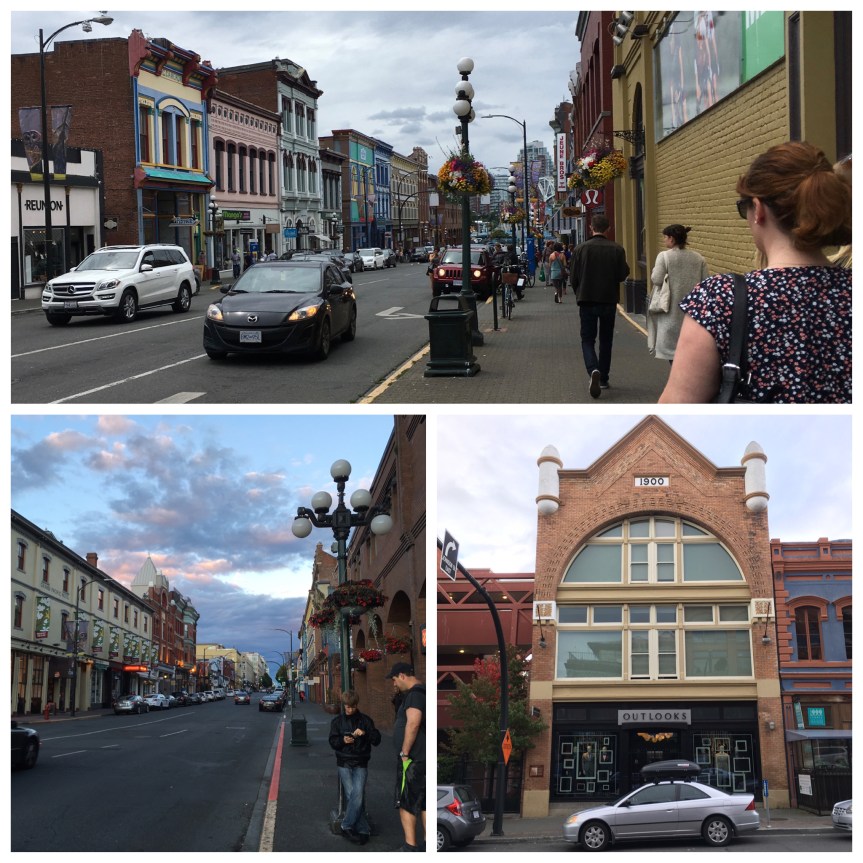


 And then Victoria has different districts, and again, if you stop and look you’ll find plaques, and the like, explaining the area’s past.
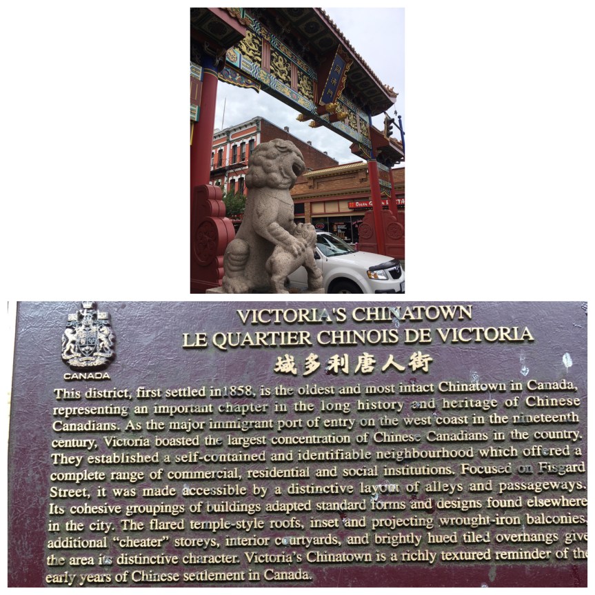


 The guy who owned this store, which was stocked with stuff that made my history major heart swoon, said that he USED to have significantly more WWII era stuff, but that the Holocaust Museum in Washington D.C. bought out most of his best items a few years ago.