Graffitied Monument: near Camp Disappointment, Browning MT

Situated along the return route of the  Lewis and Clark National Historic Trail, this site is very near another, more historically significant, site that marks the northernmost point on their trip on the same Marias river known as Camp Disappointment (reason explained at this other blog I wrote)…. an event that happened there explains why this monument is so heavily graffitied.

IMG_0581

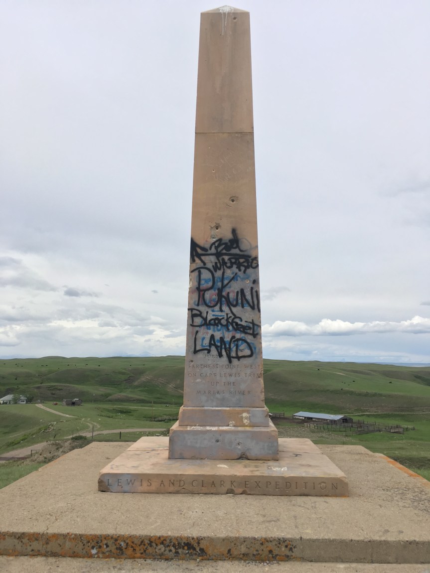
I passed this ‘monument on a hill’ as I was driving at 80mph (the speed limit) towards Glacier National Park. I stopped, backed up the car (happily there wasn’t much traffic on that road), and took the barely marked, pot holed, uncared for gravel path up to it — worrying about possibly needing to get my tires re-aligned after, or worse getting a flat. Once I got up there, and not yet knowing the context behind its defacement, let’s just say I wasn’t happy about what I saw. But here’s what the whole thing is about.

Back at the National Park’s Lewis and Clark Center, in Great Falls, MT., I had learned how, on their way back to see President Jefferson, after trying to find a tributary of the Missouri river that would travel across the 50th parrallel Captain Lewis’s portion of the expedition met up with a group of eight young Pikuni Blackfeet” warriors on July 26 on his way back from Camp Disappointment to meet up with Clark’s half of the group. After Lewis’s group met this group of Blackfeet, they had sat down to a friendly dinner, that apparently had a included a foot race and some friendly gambling. This is where the agreement among whites and Blackfeet diverges with regards to what happened next.

The next morning the “braves” (whom Native Americans argue were just young boys), are said to have tried to steal the expedition group’s rifles (at least according to Lewis’s men). A fight broke out and two of the Pikuni were killed in the only violent encounter with any native Americans during the whole expedition, part of whose goal was to open up trade and good relations with any tribes they might meet. This incident, however, had the opposite result, with the Blackfeet closing off their territory to whites for the next 80 years — till it was opened again by force. And then, to add insult to injury, from their perspective, Blackfeet became one of the ‘go-to’ tribes (along with others, like the Pawnee) for “bad/violent tribes” in American myth and movies.

As such, what happened to the monument was not just wanton destruction (although it is) but rather is evidence of the repercussions of an historic event (albeit one not described on the monument) that to most of the Anglo population of America is just a footnote in history, but to the Blackfeet is a source of constant grievance regarding how they are displayed in the historical narrative of America.

I think it is highly relevant that I learned all of this NOT at the visitors center, but rather later, after mentioning to a professor I met near Glacier National Park about what had been done to this monument. He was the one that told me that the Blackfeet tribal members are STILL seriously pissed off about this incident and blame it completely on the “invaders”.

That said, I will note that on the American side there is a single interpretation of what happened, while on the Blackfeet side there are multiple and conflicting ones, with one story saying that during it was there had been gambling and racing and that the warriors were in fact boys who were as young as 13, who had been led to believe they had ‘won’ the rifles, and were just taking what they’d believed was theirs… While another story says that Lewis’ men had said they would be distributing rifles (as trade goods) to other tribes that unbeknownst to the Anglos were in fact enemies of the Blackfeet (and the braves in this story are not described as young, as they are in the other account), and that the braves decided they needed to keep that from happening, by stealing said weapons., etc.

IMG_0580

That said, when you consider an ‘ancient history’ like this, with more recent events, graffiti like this becomes a bit more understandable, if no more acceptable.

However, the issues come close to home than that. While most Americans know nothing of this, in the not too distant past, the late 1990’s, a now deceased Blackfeet tribal member by the name of Elouise Cobell brought a case titled, Cobell v. Babbitt against the United states Department of Interior based on her own investigation of their practices that she said “revealed mismanagement, ineptness, dishonesty, and delay of federal officials”of indian trust assets (money owned by the government but held in trust for Native Americans… to the tune of $176 billion — with a B. Not that long ago, 2010 a government approved settlement was finally reached of $3.4 billion, making this the largest class action settlement against the government to date; of course some of this money will go to compensate individuals, such as the lawyers who worked on the case, as well as tribal members who paid out of pocket to bring it forward, however, the rest will be used to buy back tribal lands Native Americans have been forced to sell away to pay off debts (placed on them because of the remunerations they were not receiving), and to set up a $60 million scholarship fund.


Talking Penguin Statue, Cut Bank MT

IMG_0578

Located off the side of Highway 2 on the way to Glacier National Park, I hadn’t actually found this on any my traveling apps, just happened upon it while heading to my hotel. Upon later research I learned that, assuming it is working — which it often is not, this statue is supposed to talk — “bleating out the slogan, “Welcome to Cut Bank, the Coldest Spot in the Nation!“. The title of coldest spot in the Nation is apparently contested, and I suppose it kind of depends on the year.

Sip ‘n Dip Lounge & Tiki Bar

There is a mermaid with bright purple hair swimming in the tank in front of me; seriously. Sip’n Dip was named the #1 bar on earth by Gentleman’s Quarterly (GQ) in 2003 (I shit you not)

IMG_0571

This place embraces everything that is tacky and garish; It has patent leather yellow and blue furniture, woven palm fonds on the ceiling (along with bamboo) and folks drinking lots of fruity drinks with little umbrellas in them. It is Americana that hit it’s heyday back in the 1960’s (shortly after Hawaii became a state), that then almost disappeared, only to revived again in the 1990’s:

I present to you a Tiki bar where girls in mermaid costumes swim in front of you.

IMG_0573

I ordered a shrimp cocktail and an herbal tea — is it me or does the shrimp cocktail remind you of the movie Beetlejuice

Unfortunately, Piano Pat who was 79 in 2013, may have passed away, as I didn’t even SEE a Piano in there

Lewis and Clark Interpretive Center

Well developed National Park Center; Explains all about the Lewis and Clark (government funded) Expedition, May 14, 1804 – Sept. 23, 1806, their ‘scientific discoveries’ along the way, and some of the issues they came up against. This location along the Missouri River, in what is now Great Falls Montana, marks the first major hiccup in the expedition — the falls themselves.

IMG_0531

For those who don’t REALLY know their US history, let me set the context: An issue I didn’t see discussed in much detail at the Lewis and Clark National Historic Trail Interpretive Center (eeeie what a mouthful!), nor anywhere really (and that includes high school US history books), but one that’s highly relevant to understanding the Lewis and Clark Expedition has to do with the boundaries of the Louisiana purchase… because the fact is they were more than a bit vague. Everyone now a days assumes that Jefferson of course knew what he was buying, but the truth is far from it. Neither the French, nor the Spanish had ever carefully mapped what the thing was when passing it back and forth between them, and other than it’s eastern boundary being marked by the Mississippi River (whose northern end was as yet uncertain) but included various French settlements along it, and in the South by the Gulf of Mexico, it’s northern and western borders were kind of a murky topic — so that when the U.S. bought it, they had agreed to a contract of sale that had very vague language in it.

For the purposes of Lewis and Clark, one of the western/northern boundaries included in the contract was the entirety of the Missouri River — whose limits were UNDETERMINED!!! The further west and/or north they could mark it, the greater the size of what President Jefferson had purchased. Jefferson in fact went one step further (taking advantage of the contract’s vague language) by claiming that because of how the language in the contract was written, the western boundaries would include any and all rivers that drained into the Mississippi (so not just the Missouri, but also any of the waters that drained into it). As such, Lewis and Clark’s expedition also had to try to mark, by Jefferson’s interpretation of the language, just how far north and west that boundary lay.

In other words, BEFORE President Thomas Jefferson had even completed the purchase of the Louisiana territories from France in 1803, he had already begun the process of commissioning multiple explorations to map and explore the contents and boundaries of those unknown and newly acquired lands — as delineated by his definition, which was not likely to be accepted by our geographical neighbors. Lewis and Clark’s northern expedition, which extended beyond the purchase, to investigate what is now the ‘American’ west (territory that, at that time, hadn’t been claimed by anyone — think Oregon, Washington, Idaho and parts of Wyoming), was therefore only one of many groups of explorers that Jefferson had sent out, albeit the must famous of them. In large part, he was hoping that they would find the long fabled (they’d been hoping to find one since Columbus) ‘western passage’– a practical, and easily negotiable route (preferably a waterway) across to the Pacific Ocean; but more importantly, he wanted to send settlers so that America could establish a presence in those unclaimed territories before the other European Colonial powers managed it. And of course, since they were going to be out there anyway, they were to document the resources that came along with those lands, new plants, animals, geography, and if possible open up trade with various tribal groups they met along the way.

As you can see from the above map, the total territory of the purchase, as ultimately marked out by the various explorers, including Lewis and Clark, using Jefferson’s interpretation actually crossed beyond the current 49th parallel borders over into the 50th parallel, or what is now Canada.

The attempt to get that little bit extra is what led to an historical incident between Lewis’s group and the “Blackfeet” tribe’s warriors, which for whites is only an interesting footnote in history, but for the Native Americans has continued to be a very sore point of contention to this day. As is often noted, history is written by the victors, and as such, the story, as told at the center, goes this way:

On the return trip (after having already crossed the Rocky Mountains and followed the Colorado River to it’s mouth) Captain Lewis’ group following the Marias River as far north as they could in an attempt to cross the 50th parallel. The farthest point north they got to was named “Camp Disappointment” because it didn’t go as far north as they had hoped. Retuning from their ‘disappointment’, they met a group of eight young Pikuni Blackfeet” warriors, who they had a friendly dinner with, but the next morning a fight broke out and two of the natives Americans were killed (shot in the back) in the only violent encounter with any native Americans during the whole trip.

However, as I learned later, the Blackfeet tribal members are STILL pissed off about this incident and blame it completely on the “invaders;” They in fact tell a different story of what happened, and the difference has let continuing ill will on the part of the Blackfeet tribe towards the American people. Additionally, the whole thing was for naught because the British, never accepted Jefferson’s headwaters interpretation of the contract and it remained a point of contention with the US government until the signing of the Treaty of 1818 (which actually has three more names, depending on whom you ask), by President James Monroe, at which time the agreed upon boundary was set to the 49th parallel, where it has remained ever since.


Returning to the attraction itself, apparently following the Lewis and Clark trail is a great favorite with the RV crowd, as I learned at this center, so the National Trails System has invested a lot of money into making the trip worthwhile for them. I also learned that this is not the only federally designated “drive,” but that there are in fact 30 different historic and Scenic ones (and no, I’m not including hikes in that number); Of those ‘drives,’ (other than this one) I’d only so-far spotted two.

The Trail of Tears, which is a bit amorphous due to it’s very nature; it wasn’t one trail; so, instead of a clearly marked path you get a load of signs located on pretty much every government road that existed at that time between the Cherokee territories and what is now Oklahoma, as well as a few waterways. As a result, I had spotted signs for it all over Georgia and Tennessee.

The Appalacian Trail, this one is sort of famous, with folks traveling from all over the world to either drive, or more often to hike it.

In the Lewis and Clark Interpretive Center you will find the obligatory gift shop, an auditorium that hosts lectures, and shows two movies (one about the portage of the boats past the five waterfalls that give the town it’s name, and the other movie was especially made by Ken Burns for the center, and covers the whole history of the expedition). There was an elderly docent, who was a pretty funny guy, who also gave a not G rated speech about the expedition, that he said he’ll only do it when there are no kids in the auditorium (or they are with their parents). Unfortunately, I didn’t have time to stay for that because sidewalks roll up in this town at 5pm and I had other things I wanted to see before then. 

IMG_0564

Just about a mile or so west of the center are the first set of falls.  According to the national park staff person, when they built the dam they intentionally put it a bit back, behind the waterfalls so as to not destroy the “pretty” — there are in fact five of these along the Missouri River near Great Falls, MT (hence the name). These are what Lewis and Clark came up against in their attempt to find the source of the Missouri (which they believed would lead them to the non-existent ‘western passage to the Pacific Ocean’ that they were looking for). It forced them to pull their boats out of the river and move them over land till they got past the falls (uphill) …. only to discover the source of the river was the rocky mountains, and that they could pick up the Columbia once they got past there, but that there was no easy passage — as hoped.

IMG_0521

After you leave the Interpretive Center you should also check out the natural spring just down the road (east) from it (see 2nd map)

It is a natural spring that Lewis and Clark found, and they were able to use the clean water from it to help Sacajawea get over a very bad illness that they were afraid it was going to kill her before they had reached her tribe (they needed her as a translator).

Located directly adjacent to the Missouri River, the water that flows from the spring  (if you look into it you’ll see the water bubbling up), flows to the Missouri River — making it it’s own river, which has been “named” by the Guinness World book of Records as being the shortest river in the world (but there are a few other ones in Europe 1/2 as long that would argue that).

My national park pass came into use again, also I leaned that if you gave a disability (and proof of it) for $10 you can get a lifetime parks pass, had not heard about that before.

Montana’s ‘Scenic/desolate’ Highway 200

Today I did well over 300 miles (maybe six hours???) with most of it driving through almost NOTHING, and I mean NOTHING … but prairie… I drove past maybe three ‘gas station towns’ (ones that seem to consist of little else), saw very little traffic, and for miles and miles ….. NOT EVEN COWS!!! It’s one of those things that is definitely worth doing, ONCE… (would be better in an RV, because… bathrooms)

Backstory:
Today after spending two hours driving around the southern part of Theodore Roosevelt national Park, in Medora,North Dakota, I made the decision that I was not going to go to Yellowstone Park, as I had been planning to do, because there just wasn’t time for it. It would have meant staying on Interstate 94 (which for the most part goes west) as it looped a few hundred miles south/west (away from Canada, with a 2 night pit stop just south of Billings at Yellowstone). I would then have stayed on I 90/94 (the two join again up at Billings, MT –they also overlap in the Chicago area, so I could have easily taken the more direct I90, if my goal was Yellowstone) until I got to Butte MT, where I would take Interstate 15 north (hence staying on major highways the whole way).

While driving around however I realized I just didn’t have time to do it all, as my rental in Canada, which was already paid for, started June 1, whether I was there or not — and my trip so far, with all the pit stops, which is the only reason TO do a road-trip, was taking way too long. Also, having not scheduled in any rest days, I was starting to get a bit road fatigued after five straight days of driving. Also, my thinking was that if I spent the two days in Yellowstone I wouldn’t be able to spend any real time in Glacier National Park, nor at Banff… but would have to do a forced drive to British Columbia (and how likely was it that I would ever pass by Glacier National Park again before its namesakes had completely melted?).

What came to mind was highway 200; the night before, while looking at a map, I had noticed that there was a different, and far more direct path from Roosevelt Nation Park to Glacier National Park, via MT highway 200 (which I later learned the state advertises as scenic, but that bloggers describe as lonesome), that I had ignored till then as I was still intent on going to Yellowstone. But now, realizing I was simply running out of time (I had not planned on spending most of the two previous days in the Badlands), and made the decision. I contacted the Airbnb owner I had been talking to about booking  her place … and apologized (I had been telling her I would book once I knew for sure when I’d be there, but hadn’t actually made the commitment), reset my mapping software for Great Falls, MT (the next major city along that route, after 200 and 87 merge), and hit the road…. Drove to the small town of Glendive, Montana — had enough good sense to fill my tank, and then on to 200…

THAT SAID….

Let’s just say, I am a very stupid, naïve city girl. I looked at the map and I saw that there was not much of interest between the National Park and Great Falls Montana, and I said to myself “Okay. It’s no big deal I’ll drive and if I get tired I’ll stop somewhere along the way, have a meal or something.” HA HA HA HA….

These two pictures were taken after I’d been driving quite a while, at 2:42pm outside of Lindsay, MT, a town that is maybe 4 blocks square, and consists of a post office, a gas station — if you can call it that — and maybe four houses (no seriously, zoom into the map)

Then my bladder started to scream… and I came across the ONLY rest stop along the route, which was initially completely deserted, but I had to go! So I park the car, and with images of “gee, this would be a great place to hang out if you’re a rapist or an serial killer” I creeped into the building, looking around nervously, and checking the bathroom for occupants before quickly going in and locking the door… and then I left, also worried about who might be waiting for me as I exited… and found that there was one other car now parked in the lot, with what seemed to be two local teens meeting up for a toke… we nodded at each other and I pretty much dove into my car… me, neurotic, NAH

I have to say though… the country I had been driving through from the national park to here had been gorgeous. A lot of it is flat, but occasionally you dip into ravines that are impressive …  Add to that the fact that for most of the way you are completely alone… as far as the eye can see (which is pretty far), and flying along at 80 mph (which is the MT speed limit, because really, who are you going to hit? Did I mention not even a cow?!) down a road with so many dips and hills that it’s a bit like being on a roller coaster. (That said, maybe if you’re in an RV you should batten down the hatches first.)

About three hours after the the Lindsay, MT, at 5:05pm, and I had just passed by the glittering metropolis of Sand Springs, Montana (am being sarcastic) which consists of…. I kid you not, just a post office (no really, look at the map)

And then at around 6:11pm I saw something really exciting outside of the window, keep in mind it’s May 25th, it’s almost June (and I’m from Chicago), which is not only flat but by this time of year, approaching hot.

IMG_0519

I was like “SNOW!!!” On mountains!!! (Now that I’m looking at maps, I think I was just west of Lewiston, MT and looking at a mountain called “Old Baldy”)

Shortly thereafter, I had driven for about six hours straight and was bleary eyed as hell, I started to re-enter something approaching civilization (Lewiston, MT), i.e., I could get data and phone again on my smartphone, and fill the tank up.

For the last six hours there had been no Wi-Fi (ARGH! Withdrawal!!), there was no cell phone… there were no people … There weren’t even a lot of cows 

After I got to blogging about this, I found this YouTube video made by a trucker which gives you a sense of it, only he was driving east of Great Falls, MT, while I was going the opposite way, west towards Great Falls… but honestly, not all that different.

https://en.wikipedia.org/wiki/Montana_Highway_200

Afterthought: I wrote this over 3 years ago in May 2016 and since then it has become by FAR my most read blog post, as in 3 to 5 people every day … If some of you readers could do me a favor and post comments at the bottom of this as to explain to me WHY that is I’d appreciate it. Honestly, the mind boggles!

[2nd afterthought: it has been almost 5 years since writing this, and it is still one of my most read posts:

To those of you deciding whether or not to take the route, let me say this: if you really want to get even a tiny bit of an inkling of the perils settlers faced when crossing America in wagons, this is probably as close as you can get to it in the modern day. You really should PLAN and prepare for the crossing. As to why bother, being able to grasp the big emptiness that is much of America is sort of an experience in and of itself for us city folk, one that heavily traveled highways do not offer… and in my mind makes me glad I did it in retrospect. That said, it’s the sort of thing that I’d say must be done ONCE…
The Japanese have a saying:
度も登らぬ馬鹿、二度登る馬鹿  which translates to:  “A wise man climbs mount Fuji once, only the fool does it twice.”
That said, make sure your car is in good order, your gas tank is full, and load up on food and water, just in case your car breaks down, before starting this drive.]

Rough Riders Hotel/Medora ND

Historic, non-chain Hotel at the edge of Theodore Roosevelt National Park, suggested to me by park staff. $99/night during the winter, $129 during spring and fall, and $200 during the summer months (high season).

IMG_0462

This hotel is way nicer than I expected to be. Fairly fast Wi-Fi free, my room was really nicely decorated….  very plush looking, and the bathroom was gorgeous. People don’t tend to come to this town unless they’re going to the national parks. Also, there is supposed to be a ghost of a young boy who haunts the top floor of the building — no I did not see it.

IMG_0463

There’s a huge library inside, but unfortunately you’re not allowed to take the books back to your room. While there is a parking lot, it is so woefully small, so that I had to park on the street, even though the Hotel was no where near full.

Medora is a really cute town. The whole place looks like it’s out of a Wild West movie with elevated wooden sidewalks, swinging doors, etc. However, to quote one of the locals, “this is not a normal town.” One guy I talked to told me that they have a sort of transient population of folks who are here yearly to work the season, but otherwise can live as far afield as New York City. The permanent population is (according to wikipedia) only about 100 people, or 27 families.  As such, only a handful of the businesses in town were open on Tuesday May 24th, the day I was there — for example only three restaurants out of twelve and one of those was a breakfast only place, the rest were all closed till the coming Thursday (the day before Memorial Day weekend) and I was told that the staff who work those businesses were only just starting to return to the town, so there was a bit of an ‘old friends reuniting’ vibe going on at the restaurant, gas station, etc., while I was there.

I ate my dinner, a buffalo ribeye steak, at the Little Missouri Dining Room and Saloon (VERY tasty — wish buffalo were more common). There were only two folks working the front of the house, and they seemed pretty overwhelmed because the place was completely full with tourists, bikers (who seemed to be at least semi-locals), and other returning locals.

The next day I filled my tank at the only station in town, from a gas from a pump like I haven’t seen since before I learned how to drive; I actually had to ask for help on how to get it running. Inside the shop they were handing out free breakfast sandwiches — as many as you wanted, and massive ones — because “you know it’s not breakfast time anymore.”

Teddy Roosevelt National Park

You can just view it from a viewpoint/visitor center off of Interstate 94, or do the right thing and spend the night in the area, and really appreciate the THREE units of the National Park (there are two main ones, and a third small one — the site of Roosevelt’s ranch, which I didn’t find out about till after) in all their dangerous beauty.

IMG_1525


I94 Exit 32, Belfield, ND, brings you to the Painted Canyon Visitor Center, where if you don’t have time to really stop and see the place, you can at least get a taste of it. The visitor’s centers tend to have limited hours (they’re usually all closed by 4:30 or such), but if you get there when open the staff are very helpful with suggestions of how best to enjoy the parks, and places to stay

It was also there that I learned about the fact that there are Two main Unites to the park: North and South that are about an hour apart from each other, connected only by government owned grazing pasture lands (not interesting, unless you’re a farmer), each of which will take you a good two hours or more just two a drive drive through (assuming you’ll be stoping for photographs along the way). It was then that I decided I should stay the night so that I could do both parts, and it was a staff member who told me about the Rough Rider’s Inn in Medora and gave me the phone number so I could make a reservation for that night.

IMG_1526

North Unit is in fact the better one, to paraphrase the young guide who worked at the Painted Canyon Visitor Center, it has everything the south park does, only twice as big, twice as nice, and there are more animals…. and for all that… fewer visitors.

Like WAY fewer… It was like I was practically the only one there (although not completely alone), I was standing there listening to really loud birdsong and crickets … and I was only a few days shy of the main season. According to the staff I’d spoken too, if I’d shown up a week later, it would be me following a whole row of cars and hearing mostly the sounds of visitors.

To get there from I94, you have to take North Dakota state road 85 (exit 42), and drive for a full 52 minutes north; along the  way you’ll drive past the sweet crude gas station and convience store (nice place, clean bathrooms, friendly staff)

IMG_1527

There are so many buffalo here that they are blocking the road and I can’t get out of the park!

IMG_1528

To get to the entrance to the South Unit of the park, you essentially have leave I94 either at exits 24 or 27 (depending on which direction you’re coming from) towards the town of Medora (which has an historic hotel I really enjoyed), which is sort of a mini cowboy-themed tourist mecca, .


Sadly, I didn’t learn about the Elkhorn Ranch section of the Park, the historic part, till well after I had left the area. As a History buff it might have been nice to see where Teddy’s ranch was (but isn’t any more). But I have a feeling the staff didn’t mention it because it is kind of a let down ….

Enchanted Highway

Badly marked roadside attraction that I only spotted it because a local had suggested it to me; Although she said that of all the outdoor art pieces the best was the geese by the I94

IMG_0316

I was told about this by the local lady who took my photograph at the Sue the Cow; I had not heard about it before that. Apparently it’s a 32 mile piece of state highway (a 2 line one) along which you’re supposed to find a bunch of really impressive art. I only know this now because afterwards I looked it up on line, and was more than kind of annoyed because while there are five pieces in place, with another five on the drawing boards…  and even though I drove down that road for a full half hour at about 60 mph (and then the same distance back to 94), and I only managed to spot one other piece — some deer jumping a fence placed next to a sort of maze of iron gates.

… I simply could not find the rest of it.  I kept driving and driving and finally started to get nervous, because there were no signs telling me if I had missed them, or how far to the next one, or anything, so that I finally just turned around and went back to 94.

Much later I found THIS MAP… which it would have been really helpful if it there were displayed along the way — which it wasn’t, even though there was a display board by the deer

IMG_0318

Something in the way of an, “you are here” type map would have been nice … Please note just how FAR it is between object 2 and 3 on the map? Odds are if I had just kept going I’d have found it, but like I said, I was starting to get nervous that I had missed it all and would just keep driving down this rural highway for hours out of my way.

While I applaud the idea, I’m not sure it’s worth going two hours out of one’s way (there and back) for a few pieces of art… it would have been better had they kept them near to I94

Salem Sue

Salem Sue is a MASSIVE cow statue, so big you can see it from at least 3 miles away while Driving down Interstate 94

IMG_0297

I was a little bit concerned that maybe this cow was overhyped, because I’ve seen a lot of very large cows recently, however…. Damn! That is a big cow! You start seeing it about 5 miles down the road, and you can’t help but see it  

The view from up there is also pretty nice… well not the cows backside, but the view

IMG_0299

I had to go into google to change their location for Sue, which was majorly wrong… the one below is parallel to her, but just after where you meet the entrance to the dirt road that drive to get to her.

Since then, I got word back from Google, who have changed the location to where I said it was,


Five Nations Arts

This place is huge! It’s a co-operative store run by the five local tribes: Turtle Mountain Band of Chippewa, Three Affiliated Tribes (Mandan, Hidatsa & Arikara), Lakota and Dakota. All staff are tribal members and the art is all sold on consignment.

IMG_0294

As a general rule, when buying Native American art if you are not buying it directly from the artist, it’s best to search out these sorts of places, as they never take advantage of the artists — which most other places will do.

The reclining woman tempted me but I do not currently have a local friend to hold on to it for me (I did recently buy a painting in Georgia, which I left at a friend’s home for safe keeping) and she was very heavy (solid stone), so lugging her around in my car till I get to such a location is not feasible. Sigh…

Like I said, I spent a summer doing research into economic development on an Indian reservations (with most rez’s having the highest percentage of poverty in the country). Most native American artists don’t understand the business aspect of their work, and will tend to sell at a overall loss (for a variety of reasons). Gallery’s like this one, which are run by the tribes, ensure that this does not happen. Additionally, most stores that sell NA art, jewelry, etc, add on massive profit margins so that you will pay FAR more buying from them, than from places like this. So it really is a win win to try to search these places out.

IMG_0290


The woman showed me the bunch of really beautiful rings (above) and said “these are made by our youngest artist she’s 8 years old, she’s been beading since she was about two.”