Clanton’s Cafe, Vinita, OK

Clanton’s cafe on Route 66 in Vinita was one of the places I had marked as MUST try their foods… and I even planned my day to arrive there around dinner time… only to find it was closed!

IMG_1179

Clanton’s was one of the restaurants along the trek I was really looking forward to trying. This place has no shortage of accolades from TV and magazines, not to mention getting almost 5 stars on TripAdvisor and 4 on yelp. AND they’re supposed to have the best Chicken Fried Steak on Route 66, which is one of my favorite dishes

IMG_1180

But MY good luck, between me planning my trip and arriving there, they’d posted NEW hours which include being closed on Sundays. So

fullsizeoutput_4c12.jpeg

Advertisement

Afton Station’s classic Packards, Afton, OK

Located directly on Route 66, The Afton Station Packard Museum, is yet another historic Gas station and mechanics shop that has been repurposed into a museum. This one is dedicated to the Packard and other classic cars — but I can’t tell you much as it was closed-up by the time I got there (4:30 ish on Sunday).

IMG_1194

That said, the town it is in is DEAD… to the point of scary; I’d say a good 80% of the businesses on this street are closed up and the few people that I saw (were more stumbling than) walking around all looked suspiciously like meth users.

IMG_1183.JPG

So between that and the weather, I was pretty motivated to not stay here too long. I did however peer through the windows, and from the look of it,

IMG_1127.JPG
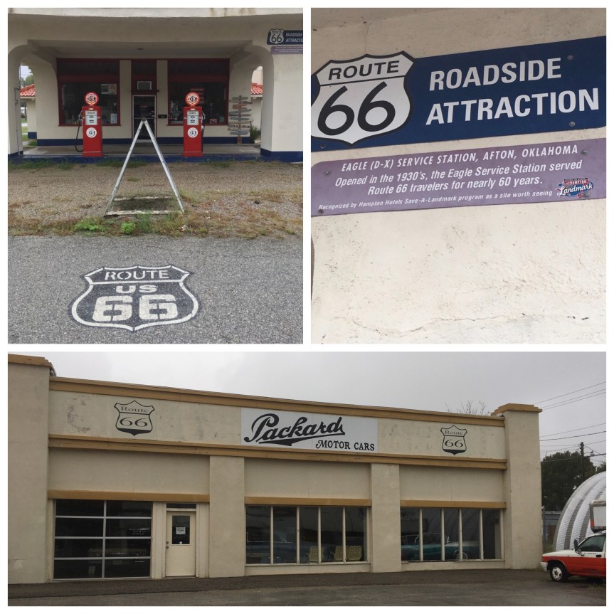
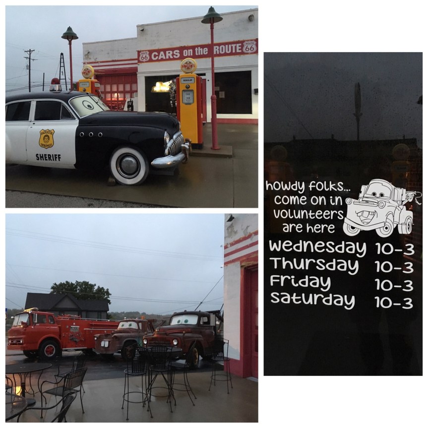
A very large gift shop that once again is mostly filled with EXACTLY the same merchandise I’ve seen elsewhere. IMG_1126.JPGAnd a collection that consists of seven cars shoved into the garage, with very little to no explanations. IMG_1129IMG_1128

OK-KS-MO Tri-State Marker, Joplin (OK, KS, MO)

This is what it says it is… within the borders of Joplin (MO) there is a fairly well hidden marker (not far off the old 66 route) that marks a spot where three states meet: Oklahoma, Kansas and Missouri. That said, it is seriously NOT easy to find. My car’s GPS couldn’t find it, and ultimately I had to resort to google maps (which won’t work if you don’t have data coverage in that area)

IMG_1216

It is located down very old heavily pot-holed (seriously, watch out or you’ll screw up the alignment of your wheels) road that is more gravel than asphalt, just off a roundabout. And alongside a large pillar (there’s nothing ON said pillar to explain why it’s there).

IMG_1217.JPG

I have a feeling that the reason the road is in such disrepair is because it’s sort of a no-mans land… the road to the monument lies RIGHT on the Missouri/Kansas border… although google maps puts it JUST at the edge of Missouri.

fullsizeoutput_4bf9.jpeg

[Am I the only one who always get confused between Missouri, MO…. Montana is MT … Massachusetts, MA and Mississippi, MS]

Route 66 Gateway Sign, Miami, Oklahoma

Just as you enter Miami Oklahoma you see this really nice Route 66 sign

fullsizeoutput_4c0e.jpeg

The Miami in this case is not the Miami of Florida, rather it denotes the land that had been assigned to the Miami tribe, a people that had originally lived in what is now Indiana [where they are no longer recognized as a tribe] but were forcibly moved here when the white populations in Indiana wanted them gone. This relates to other places I’ve visited such as Tippecanoe Battlefield, where after the battle of the same name the Indians who had followed Tecumseh, were forced to move to here, to Oklahoma (i.e., which literally translates to Indian Territory — discussed in greater length on this blog post) while the ones who did not support him and had decided to live like white men were allowed to stay in Indiana.

IMG_1201.JPG

Indian Territory Memorial, Quapaw, Oklahoma

The word Oklahoma actually translates in the Choctaw language to “red-person,” specifically, ukla=person and huma=red, and the entire territory had initially been ‘given’ by the US government as a territory intended solely for the tribes… and it is where the tribes from the southeastern states were marched towards on the Trail of Tears.

IMG_1209

This Memorial located directly upon the old Route 66 route marks one of the boundaries of “Indian Territory” a continually shrinking zone that the American government promised to leave to its native populations that at this point is more easily observable via the names of places than on the faces of its occupants.

Route 66’s Rainbow Bridge, Riverton, Kansas

The Rainbow Bridge in Riverton KS, (Baxter Springs is the closest town) dates back to the two lanes period, and is directly adjacent to a much newer version of 66.

IMG_1229.jpg

One of the things you realize driving route 66 is it developed in stages. There’s the original one, which was generally two lanes and existed in a time when there wasn’t much traffic… then increased usage necessitated wider bridges, or that the road be moved entirely… and then there’s the most recent version some of which I’m beginning to think was organized AFTER the road had been decommissioned, when it started to become a tourist destination.

IMG_1221.jpg
View from 66’s newer route and the new bridge

Apparently, in a fight between the county, which wanted funds from the government to build the new bridge whose rules demanded demolishing the old bridge, and the Kansas Route 66 Association… who clearly wanted it preserved, a compromised was reached. And now the bridge is listed with the National Register, so it will never be demolished, and has since been used as local for filming route 66 specials on TV.

IMG_1113.JPG

Cars on the Route, Galena, Kansas

Yet another historic gas station repurposed to take advantage of renewed interest in 66 that the Pixar Movie Cars generated. Every car has been anthropomorphized, and the police car is claiming to be from Radiator Springs. (From what I read they also serve sandwiches and stuff to generate income.)

fullsizeoutput_4c0a.jpeg

As is clearly obvious from the photo, it was approaching 7pm by the time I got here, and it was raining, and the temps were dropping precipitously … I think it was already like 47 F according to my car’s “outside” thermometer (in MID October, i.e., unusually cold).

IMG_1102.JPG

The website I had looked at said they were open on Sundays….AND, I got there on a Sunday (this part of the country seems to close down on Sundays…), but apparently not so much.

66 Drive-In Theatre, Carthage, Missouri

I TRIED to see this still functioning Drive-in theater on Route 66. UNFORTUNATELY google maps lied to me yet again… the drive on 66 rather than on the freeway, so slower (especially when you add stops along the way) had me showing up here past 7pm and with it being overcast and raining….

IMG_1235.JPG

As it turned out, it was actually closed for the season, and THIS was all I actually managed to see of this  old-fashioned Drive-in theater (and it was Sunday night and raining, so even if it had been offering a movie it wouldn’t have been showing anything that night). That said, this section of 66 is profoundly back roads and rural. VERY little traffic and more than a few deer (be careful). AND the temperature were dropping. By the time I finally managed to get to gas station (I was in dire need of a pee) the RAIN, as in floated in the air was clearly behaving more like tiny snow flakes than rain… so from that point on I opted for the highway as the much safer option to get me to my hotel.

I’d also driven right past The Gay Parita Sinclair Station on Route 66 (they got a National Geographic write up!), but it was SO dark there was nothing to really see or take photos of… no nice neon  or anything