Getting your kicks on route 66, the greater LA area edition

I have begun my route 66 road trip!!! Only, I’m doing it backwards from California rather than starting in chicago like the song does.

Rather than beginning it on the Santa Monica Pier, which is where the powers that be want you to begin, I started my trek on the 2nd historic beginning of the route (the furthest end point). Namely, I started on the corner of Lincoln and Olympic Blvd — adjacent to the freeway, and a walking distance from the pier. That said, I could not find any markers there…. (I THINK there may be two Lincolns and Olympics, one on either side of the freeway, with Lincoln being one way on each side… the sign MAY have been on the other side.)

IMG_7183.JPG

That said, the ORIGINAL ending point didn’t make it past the corner of 7th and Broadway in downtown Los Angeles. It only extended to Santa Monica as the greater LA area grew, with Santa Monica being a desirable location to live and downtown LA degenerating into a massive skid row (There are over 60,000 homeless living in LA county, and they’ve created a tent city in downtown LA takes over 50 square blocks, HUGE! With only nine toilets per 2,000 people…. If you’ve never seen it, I suggest watching this video)

This is clearly NOT what tourism officials want tourists focusing on… So Santa Monica is a MUCH nicer start….  I made my way to the Pier in order to get the “tourist” aspect

IMG_0134.JPG

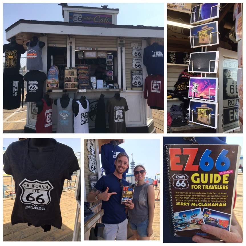
This couple from Germany was just finishing up their Route 66 trip, and were strongly advising this book to me, which this shop called 66-To-Cali had for sale… I gave it a look. I think it’s more useful if you have TWO people and one person can follow the book giving directions to the driver. So, not so good for me. I HAD wanted to buy the California 66 end of the trail T-shirt but they run VERY SMALL and they didn’t have one my size.

A video I took while there

IMG_7201

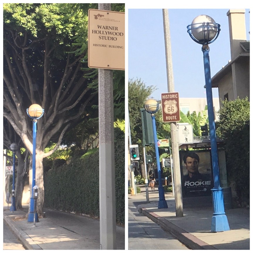
Then I started the drive, stopping to take snaps of various “Historic 66” signs along the way…

fullsizeoutput_481d
14th & Santa Monica Blvd, in Santa Monica
fullsizeoutput_481f
S. Carmalina Ave & Santa Monica Blvd in LA
fullsizeoutput_4800
Cafe 50’s on Santa Monica Blvd/W. Historic Rt 66 in LA

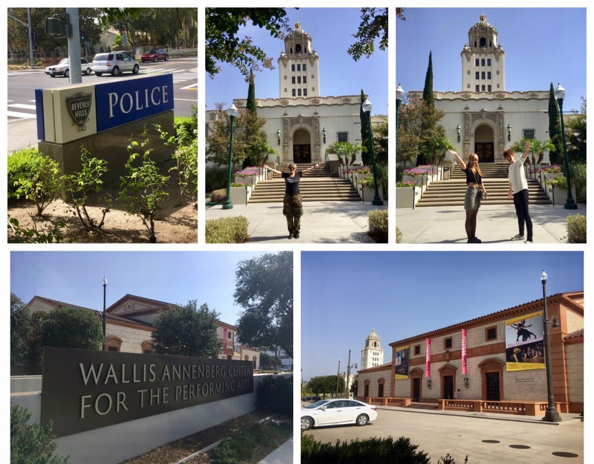
Then I hit, BEVERLY HILLS!!!!

fullsizeoutput_4821
Santa Monica Blvd and Wilshire Blvd, in Beverly Hills
IMG_7227.jpg
Church of the Good Shepherd/W. Historic Rt 66, Beverly Hills
IMG_7234
“In Beverly Hills? Rodeo Drive BABY!” — Pretty Woman

Me in front of Beverly Hills Building & Safety/Police Building… and a picture of the nice Japanese couple who took the picture for me

fullsizeoutput_49db.jpeg
On W. Historic Rt 66, Beverly Hills

IMG_0138

IMG_7261
Maple Drive & Santa Monica Blvd in Beverly Hills
IMG_0877
various locations on Santa Monica Blvd/W. Historic Rt 66, West Hollywood
IMG_7279
Santa Monica Blvd/W. Historic Rt 66, West Hollywood
IMG_0141.JPG
Santa Monica Blvd, West Hollywood (two ends of the same block)
IMG_7284.jpg
Alvarado & Sunset Blvd, Los Angeles
IMG_7287
Sunset Blvd, crossing the bridge over Arroyo Seco Parkway, in Los Angeles (near Dodgers Stadium)

So far for the MOST part I managed to stay on the road with one hick-up when approaching Pasadena where I got off the Arroyo Seco Parkway (110/66) too early…. which is sad because it turns right into Route 66 at its end.

IMG_0878

I had used Google maps to chart out 66, then found landmark addresses (some of them just being local business of no import) and plugged them in … problem is I think I ultimately plugged it into my GPS system wrong because of two very similarly named roads (Blvd vs St. vs Rd type issues).

IMG_7300
U.S. Post office on E. Colorado Blvd/W. Historic Rt 66 in Pasadena
IMG_7304
Near the corner of E. Colorado Blvd and S. Lake Ave in ‎⁨Pasadena

IMG_7305

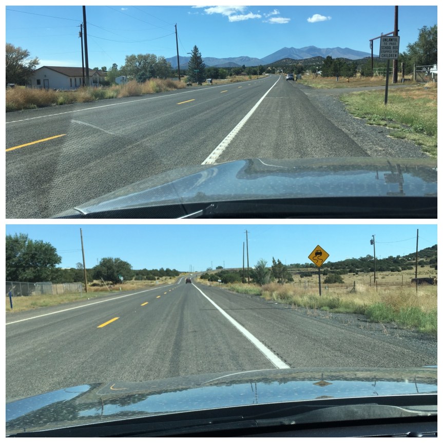
The view of the mountains north of Pasadena from E. Colorado Blvd/W. Historic Rt 66 near N. Hill Ave

IMG_7308
Saga Motor Hotel, E. Colorado Blvd/W. Historic Rt 66, Pasadena
IMG_7309
E. Colorado Blvd, just past Madre Street
IMG_7310
E Colorado Blvd/W. Historic Rt 66, Pasadena,

IMG_7311

This sign was on E. Colorado Blvd Arcadia, in front of Coco’s Bakery Restaurant (I used their rest room)

IMG_7312
Entrance to the Santa Anita Race Track on Colorado Pl/W. Historic Rt 66, Arcadia
IMG_7313
E. Huntington Drive and 1st Ave, Arcadia
IMG_7314
Huntington Drive and 2nd Ave in Arcadia, a Railroad bridge
IMG_7315
W. Huntington Ave & S. Mayflower Ave in Monrovia

There’s a Costco directly on route 66, 1220 W Foothill Blvd, Azusa, CA ….got a love it, of course I filled up on gas, used the bathroom, etc.

IMG_7316
890 E Alosta Ave, Azusa
IMG_7318
1832 E Rte 66, Glendora
IMG_7319
E Rte 66 & Amelia Ave, Glendora

At this point it was getting dark, and my stop for the night was at the historic Wigwam Motel in San Bernardino — see the blog post about that — which is family owned and if you don’t get there by 8pm you need to call and tell them or they’ll give away your room, and you’re expected to show up at a decent hour… so I stopped taking photos and just drove the next 40 minutes with no stops

IMG_0876

And then, after I checked in, I went to get my dinner in San Bernardino was a place that had the most reviews/highest— it was an all day breakfast with dinner till 10pm. Everything I had tasted homemade —Corky’s Open 24 Hrs Rialto, CA

IMG_0816.JPG

One warning… including stops it took 6.5 hours to drive from Santa Monica to San Bernardino … I was expecting it to be 4 hours, i.e., WAY longer than I thought it would, or google said it would take, to get from Santa Monica to San Bernardino

66

Elmer’s Bottle Tree Ranch: Oro Grande, CA

On route 66 in Oro Grande California is an outdoor found art piece worth visiting… a Ranch of trees made out of glass bottles

fullsizeoutput_49d1.jpegIMG_0081.JPGIMG_0082.JPGIMG_7408.jpg

When I arrived the other visitors that were there on my arrival were just leaving so I had it all to my self, and I discovered that the piece is as much about the sounds as the visuals (two videos I took)

And then, just as I was leaving a THREE mini-bus loads of tourists showed up and two freight trains passed by one after the other going in different directions, all of which would have greatly altered my enjoyment of the place

fullsizeoutput_49d3.jpegfullsizeoutput_49d2.jpeg

(I found this YouTube documentary someone made that includes an interview with the owner/artist.

Navajo Nation, Central Government; Window Rock, AZ

One of the Native American Reservations that Route 66 passes though is the Navajo Nation. This rock formation (known in Navajo as: tségháhoodzání or, the rock-with-hole-through-it), lies the city’s Memorial Navajo Tribal park, and it is what gave Window Rock, Arizona, the nation’s capitol city, its name.

fullsizeoutput_49ce.jpeg

In the park there is a stature dedicated to the tribe’s veterans (Native Americans take their citizenship and military service VERY seriously — as part of being modern-day warriors) and in particular the statue commemorates the Navajo Code talkers who were instrumental during WWII. IMG_0062.JPG

IMG_9071.jpg

Adjacent to the park are MOST of the buildings that constitute the government of the Navajo Nation.

IMG_9096.jpg

For those who don’t know, the tribes are Dependent Sovereigns with the right to govern themselves, to a point (and that point has varied). This part of the town is where you’ll find the Navajo Nation’s Counsel Chambers,

IMG_0065.JPG

The offices of President and Vice President

IMG_0063.JPG

the tribal courts (Each tribal nation has its own Supreme and District courts), and the central location for the Nation’s police force (tribes are controlled by Federal laws but not State).

IMG_9085.jpg

Route 66 near Navajo Army Depot is red not black; Bellemont, AZ

IMG_8344.jpg

Just west of the Navajo Army Depot in Bellemont, Arizona, where Route 66 officially rejoins I-40, there is an old neglected piece of Road 66 that you can’t really transverse because it no longer all connects (and has been renamed Bellemont Camp Road).

IMG_0041

This is what one of them looks like, it is mostly unused because it dead ends, and is no longer kept up by the government. But because of that we get to see the OLD pavement, and for some reason it’s RED instead of black …

IMG_0042

I had noticed this particular feature of the “OLD 66” before in Oro Grande⁩, ⁨California, this time on a road that had been kept up,  so I couldn’t really get a good look at it. What it looked like was a red road had black top placed over it… but the red was a bit wider so it sort of leaked out the sides

IMG_7401.JPGIMG_0046

Personally I’d love to know why


Western Hills Motel; Flagstaff, AZ

Western Hills Motel is on Route 66 in Flagstaff, Arizona, and has a very nice sign which is supposed to be especially impressive at night (but of course I was there at around noon)… that’s about all I can tell you. (I’m guessing the horses are animated to look like they’re walking?)

IMG_8372

This place was supposed to have award winning greek food in addition to some pretty impressive neon, but apparently five years ago they switched from Greek to Mexican ……because (and I say this sarcastically) what Flagstaff really needed was YET another Mexican restaurant…

IMG_8373

When I stopped here I was REALLY looking forward to some good Greek food. Sigh

IMG_8375

Louie the Lumberjack Statue, Flagstaff Arizona

IMG_8368.JPG

Louie the Lumberjack Statue is …. well… not very big, only 10 feet tall and made out of cedar … while his two brothers who are both used by Northern Arizona University as their mascot, are both 20 feet tall … no wonder he looks sad

IMG_8370

Louis is on Route 66, right after this intersection (going east)

IMG_8367.JPG

https://www.google.com/maps/place/Giant+woodsman+sculpture/@35.1964527,-111.6544598,15z/data=!4m2!3m1!1s0x0:0x31e1944c66d55945?sa=X&ved=2ahUKEwjpw96f3OHdAhW1oFsKHcaRDecQ_BIwD3oECAoQCw

Miz Zip’s on Route 66; Flagstaff, AZ

Miz Zip’s is a historic diner on Route 66, reputed to have good food (I didn’t eat there)…

fullsizeoutput_49b3.jpeg

that is one of the more famous locations because of its neon (which I arrived at the wrong time of day to see).

fullsizeoutput_49b4.jpeg

That said, when I got there and saw their menu (which has all I got all excited because it said buckwheat pancakes on the menu, which are much better for you than buttermilk, much lower sugar/carbs. So I tried to order one and she said “I’m sorry we no longer serve those” … SIGH, I got back in the car and back onto the road…

fullsizeoutput_49b9.jpeg

When you’re in Arizona …. “Don’t forget Winona”

Let’s face it, but for the song, Route 66 wouldn’t be the draw of international travelers that it is… I mean you don’t see vast numbers of people coming to the US to travel on the Cumberland Road, or the Lincoln Highway for that matter … that said, if you’re doing 66 you HAVE to make sure you pull of I-40 at Winona

“If you ever plan to motor west
Travel my way, take the highway that is best
Get your kicks on Route sixty six
It winds from Chicago to LA
More than two thousand miles all the way
Get your kicks on Route sixty six
Now you go through Saint Looey
Joplin, Missouri
And Oklahoma City is mighty pretty
You see Amarillo
Gallup, New Mexico
Flagstaff, Arizona
—-Don’t forget Winona —-
Kingman, Barstow, San Bernandino
Won’t you get hip to this timely tip
When you make that California trip
Get…”
[Keep in mind I started in California and am headed East]

IMG_8385.JPG

SO… I’ve done it… I’m sitting on a road in the middle of downtown Winona Arizona, and suddenly understanding why the line of the song is, “don’t forget Winona”. There is almost NOTHING here. IMG_0016In fact for the most part it’s a Gas Station directly adjacent to I-40/Route 66…  and then if you stay on the road all you see is a few houses. That said…IMG_0015
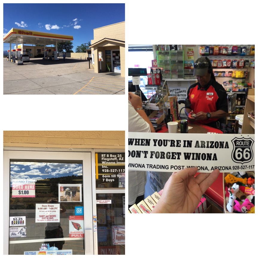
When I went back to the gas station I told the guy that I was sure I wasn’t the first person to say this, but they really needed to put a sign outside that said “don’t forget Winona” at which he laughed, and said, “you said the magic words” and he gave me this bumper sticker

The Arizona divide and some highway luck

The Arizona Divide is on Route 66/I-40, and is located just west of Flagstaff, Arizona. It is a geographic location marking the point where water either flows toward the Colorado River watershed or to the Gila River watershed

IMG_8352.JPG

As I was headed towards Flagstaff I hit a massive traffic-jam.

IMG_0007

Somehow, a truck had overturned, and if you look at the photo you can sort of see that there’s a huge crane parked in the middle of the highway trying to right the truck and all the traffic has been redirected into a single file that passed it by riding on the highway’s curb/pull over section.

fullsizeoutput_49aa
Soon after I passed the accident I spotted the sign and I pulled to the side of the road to take this photo of the sign marking the divide’s location IMG_0008

A minute or two later, I realized that no more cars were driving past me. The road was COMPLETELY empty and stayed so for I don’t know how long, because I only hung around about 5 minutes before heading towards Flagstaff. I wasn’t driving very fast, and after a bit pulled over again, wondering when the traffic would flow… and took more photos — and even watched a train head towards me and pass under the highway

IMG_0009I.e., I was VERY lucky in passing it when I did cause I could have been sitting there MUCH longer/

IMG_8359

The first McDonald’s Museum: San Bernardino, CA

This is a private Museum to all things McDonald’s located on the property that HAD been the location of the first McDonald’s. It is NOT owned or operated by McD’s corporate. The actual building had been destroyed in the late 70s — and this building doesn’t even look like that one did…  but it is on the original property of the burger joint owned by Dick and Mac McDonald, who essentially invented the fast food model… that Ray Kroc took international — AND the sign out front includes elements of the original sign.

IMG_7365.jpg

The museum was created by Albert Okura, who owns both a chicken processing empire and a string of chicken restaurants in the California, who bought the property and created this museum. Okura is a philanthropist who has invested a LOT of money into revitalizing sites along Route 66 — in addition to this one he OWNS the town of Amboy where Roy’s Motel is located and is responsible for its renovation and upkeep.

I came here as part of my Route 66 road trip. I have to admit I was kind of let down. The website I found this one did NOT make it clear that this was not the original building.

IMG_2892.JPG

IMG_2893

IMG_7373.jpg
What the original building looked like

IMG_7383.jpg

IMG_7372.jpg

And then, I was kind of irritated to discover that the collection is completely un-curated. When you walk in what you see is a collection of display cabinets chock-a-block full of stuff… as though it were a store selling collectibles rather than a museum of them

IMG_7375.jpg

                    Less is more people!

IMG_2894.JPG

IMG_7380.jpg
Even the big stuff you can’t really look at cause its just sort of all shoved in there

Essentially… They built the building they put some stuff in it and then over the years people have been bringing and/or sending them stuff to add to the collection… so that at this point they have McD’s related stuff from all around the world. Only they completely lack the space to display it in any sort of meaningful way.

IMG_7382.jpg

THESE were my favorite items because we used to have them at our house. I have a feeling my brother ended up with them, which makes me sad… but that’s why G-d made eBay… apparently you can get the full set for like $20