Echo Canyon Welcome Center Rest Area, Canyon & Trail; Utah

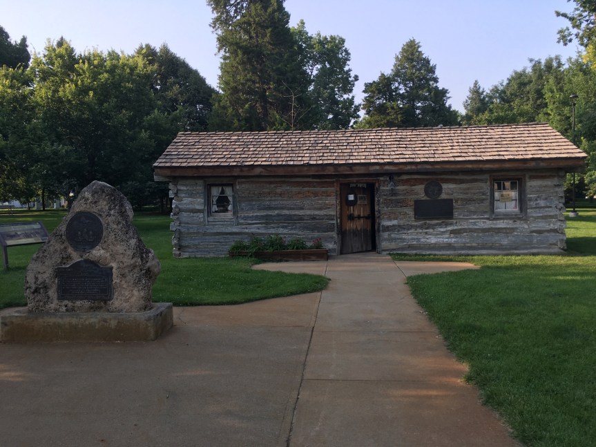
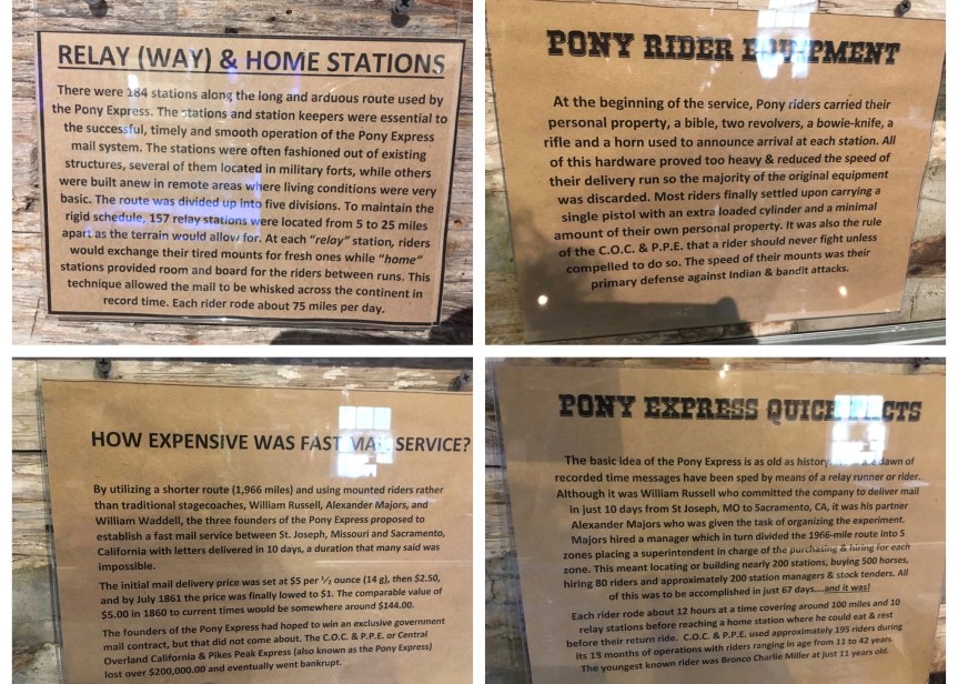
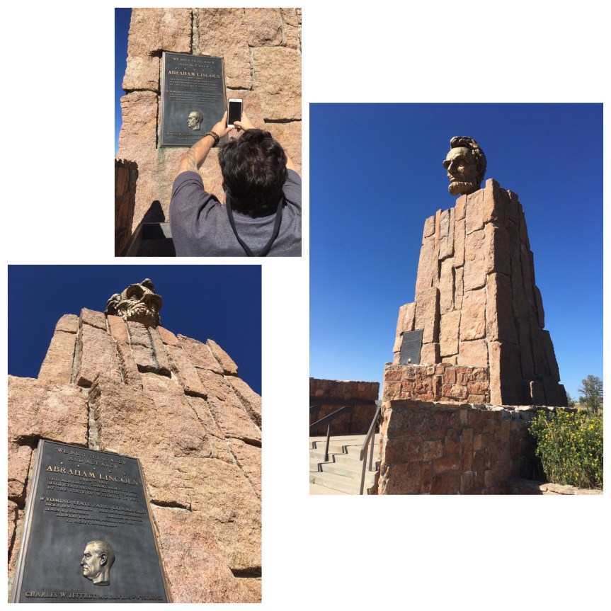
I don’t normally bother stopping at Information Centers, but Echo Canyon is a one of the most historically important locations in the westward expansion of the United States. It’s a natural pathway/pass located about half way between the grasslands of Wyoming and the Great Salt lake desert of Utah. This was a route used by (progressively) animal migration, Native Americans, the wagon trains, the Mormon pioneers of 1847, the stage coaches, the Pony Express, prospectors, the railroad (who still uses it today), the countries first transcontinental telegraph line, The Lincoln Highway and today Instate 80.

fullsizeoutput_44c9.jpeg
The pass, looking eastbound, railroad tracks on the left, I-80 on the right

IMG_2477.JPG

This is one of the nicer rest stops on I-80. The bathrooms were clean, and there was a nice but a bit steep up-hill walk to the monument that will get your blood pumping after a long drive, and teach you a bit of history.

IMG_4519.JPG

What’s interesting to me is the condition of this sign about The Road to Zion (along side the building itself, bottom of the hill) — one of the historic to America trails that I’m increasingly interested in traveling along. To put this in some sort of context for folks who are unfamiliar with the church, The Church of Jesus Christ of Latter-day Saints, i.e., the Mormon Church — is a wide collection of independent church groups that trace their origins to a man called Joseph Smith in the late 1820’s. The nickname for the group is derived from their adherence to the Book of MormonMormon being the name (I THINK) of the Latter-day Saint/narrator (??) of much of the text (I’m not Mormon nor have I any sort of expertise about the religion, so forgive any mistakes I’ve made or feel free to correct them in the comments). Anyway, the largest/richest segment of the church — and the part most politically recognized, is the one that owns the Tabernacle in Salt Lake City — and is also a politically powerful demographic (so that on numerous occasions Mormons have campaigned, albeit unsuccessfully, for the office of President of the United States — with Mitt Romney being the most recent). As such, they arranged (and rightly so) to have their migration trail included as one of the very first recognized trails of the National Historic Trails System… only to have the above sign placed at strategic locations all along said Mormon trail to Salt lake… only ALL of these signs have turned out to be highly NOT-archival (i.e., covered with a plastic coating that degrades rapidly in the elements); and all of these signs are at this point between difficult and impossible to read as result, let alone photograph; and every one of them says the same generic thing — none of the ones I’ve seen so far say anything specific about THAT locations’ specific importance to the trail… other than it’s part of it. What I don’t get, is why the church hasn’t offered to pay to have them all replaced with something better and more meaningful.

IMG_4520

This is so far the ONLY sign I’ve seen offering up any discussion of Eisenhower’s involvement in the instate system of highways

fullsizeoutput_44c8.jpeg
The pass, looking west bound

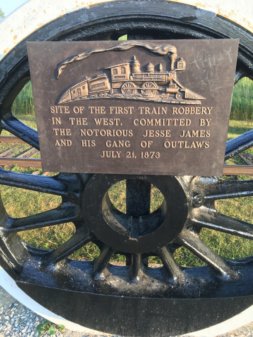
It is also a favored spot for train enthusiasts,

IMG_2478
My pics of the rail-line that also passes through the gap

as is shown by this video I found on YouTube:


Thunder Mountain Monument: Imlay, Nevada

The Thunder Mountain Monument was NOT a place I found via a  road-tripping website, rather it grabbed my eye while driving from Elko to Reno, Nevada on Interstate-80, causing me to dive out the very next exit and doubled back — good thing I did

IMG_4735.JPGIMG_2467.JPG

IMG_4737

IMG_4743.jpg

IMG_4744IMG_4745IMG_4746

IMG_2468.JPG

IMG_4750

IMG_4756

IMG_4759

IMG_4761

IMG_2469

IMG_2466

IMG_2465

IMG_2464IMG_4763

The place is kind of impressive, and reminds me a great deal of Howard Finster’s Paradise Garden in Summerville, Georgia According to wikipedia Thunder Mountain was declared a Nevada State Historic Site in 1992

IMG_4781

Passed these two on my way out of the monument and back to the highway… asked if I could take their picture and she said, “sure, he loves to ham it up for a camera”

Jesse James Historical Site, First Train Robbery in the West: Adair, Iowa

Located a short distance off of Interstate-80, in Adair, Iowa, is a monument dedicated to the very first documented heist of a moving train in the west; this occurred on July 21, 1873. The thieves in question were the notorious gang of outlaws led by Jesse James.

IMG_3882.jpg

IMG_3877

IMG_3879

IMG_3892.jpg
Road is to the far left, then the 2nd road is the off ramp, then the memorial

The memorial is located near the top of a low hill, along side an off ramp type road, so that tourists don’t block traffic or cause accidents.

I found this short segment (2.5 minutes) of a longer “Biography” documentary about Jesse James, that focus on this train robbery… or you can read the explanation I found at the site:

IMG_3883.jpg

Both sources make the point that this was sort of learning experience for the gang, in that their actions, jerking a rail out of place, resulted in a derailment of the train and the two needless deaths of  Engineer and the fireman, plus injuries to various passangers… i.e., they ultimately decided this method just made it harder than it had to be.

IMG_3887.jpg

Along with the explanation of the robbery are some posters talking about local wild plants and a bit about the town.

Bonneville Salt Flats; Wendover, Utah

The world-famous Bonneville Salt Flats is located just west of the Tree of Utah as you travel west on I-80. It is one of the few places on the planet so flat and large that you can see the curve of the planet, and so deadly that not even the simplest life forms of our planet can sustain themselves there.

IMG_4591.jpg

The  Bonneville Salt Flats is another place I’ve driven past on numerous occasions, but never bothered to take the time to stop and see until this visit. I discovered there are two ways to see the place… the first is the a rest stop on the north side of Interstate-80

IMG_4601.jpg

IMG_2370

The second option is to enter into the park itself to where the the measured mile is located, which is where the cars race. To get there, you go to the next exit west of the rest stop. There you will find a Sinclair Truck stop, that sells a collection of Bonneville Speedway t-shirts, along with the normal truck stop selection of goods

IMG_2371.JPG

and that, besides the obligatory gas, has something highly unusual for a truck stop…. a cafe that serves Indian food!!!

IMG_2368

I was so amazed when I spotted this, that I stopped to order some lunch. I ordered Sag Paneer, one of my very favorite foods, Tandoori chicken, and garlic Nan… the waiter told me that the wait for the chicken was going to about half an hour… so I told him I’d be back… and headed out to see the speedway

IMG_4633.jpg
This picture was actually taken on the way BACK to the truckstop

From the truck stop you drive down Leppy Pass Road, taking the curve in the bend onto the Bonneville Speedway Road (a two lane black top road along side which you’ll find a lot of people parked in campers)

IMG_4631.jpg
As was this one… (note the mountains)

For some reason the map won’t embed the map, so follow this link to show the spot of the final location: https://goo.gl/maps/qSFXak8XWEP2

IMG_4619.jpg

IMG_4628.jpg
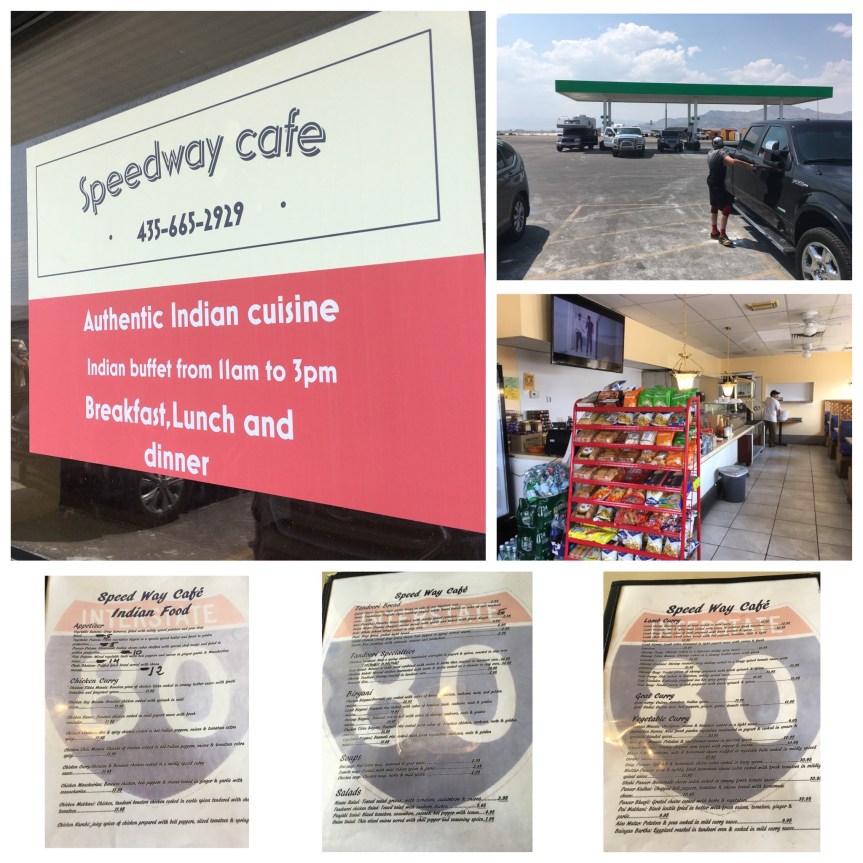
When I got there I was told that there was actually a race going on, and it would cost $20 to go out on to the salt flats… I told her I actually had to get back to the gas station because I had ordered lunch… and could I just take photos for now of the entrance way, and then come back after I had eaten (at which point I would pay to enter the area). She said yes, and directed me where to park.IMG_2372IMG_4629

After these photos I headed back to the cafe and had my lunch…. I also ordered a sweet lassi to drink with it.

IMG_4640

All of it was very tasty, but unfortunately the cook had undercooked the chicken thighs (my favorite part of the chicken too)… so he took it back in to have it cooked some more, and the chef for some reason opted to deep-fry it, meaning I still couldn’t eat it (not allowed deep-fried food).

And that’s when I suddenly had an urge to go to the bathroom (as in I really needed to poop all of a sudden). While there, for some reason…  I had the very bad luck of getting seriously sick. I was sitting on the toilet, pooping, and that black veil dropped in front of my eyes warning me that I was about to pass out. I put my head between my knees, started shaking and sweating really badly (as in heavy drops of sweat were falling off my forehead onto my glasses)… while sitting in what I knew was a cool room. I tried to stand up a few times and almost passed out each time, forcing me to sit again, and put my head right back between my knees… I tried pulling my pants up, but didn’t have the strength to do it. I was forced to ask a complete stranger to help me get my pants up. She, however, didn’t speak english; so, I asked her to please get someone who could — she spoke enough to understand that. It took her a while but she brought a guy from the shop, who translated to her what I wanted, while asking me if he should call 911, but warning me that the hospital was very far away and it could take them 20 minutes to get there. I told him not to. She helped me, and then I staggered over to the sinks and held on to them, still shaking horribly. She opened the faucets and started splashing my head with cool water, which actually helped.

When I started to feel a bit better I staggered over to the restaurant, paid my bill (poor guy must have thought I’d run out on it), sat at a table and put my head down on it and just stayed like that for about 20 minutes…. then with baby steps I got back to the car… guzzeled water I had there and waited for my head to clear so I could drive the almost 2 hour drive… I was actually pretty proud of myself all things considered

As such, I was only really able to glance at the salt flats before forced by illness to head directly towards my next hotel where I could rest … because to quote The Bard, “discretion is the better part of valor” —Henry IV, Part I, and while I am aware he meant it as a joke, I prefer its idiomatic usage, because it has a great deal of truth to it.

Carlin Trend Mining Supplies & Services — & Rolling Rock Gallery/Gift shop!!

While walking around Elko, Nevada, a gold mining & railroad town located off of Interstate-80, (I was stretching my legs before getting back on the road) I chanced to find this really NEAT shared store site called the Carlin Trend Mining Supplies Services…. This is combined mining store (i.e., mining services/goods) and temporary employment agency for the local mines,

IMG_4665.jpg

AND Rolling Rock Gallery a pretty impressive Gift shop (I shit you not) but with a definitive science geek flare.

IMG_2337

At first I thought that place was just ridiculously eclectic,

IMG_2339

but the more I looked at it however the more I realized that there was a trend that veered predominately towards things of a science nature.IMG_0024
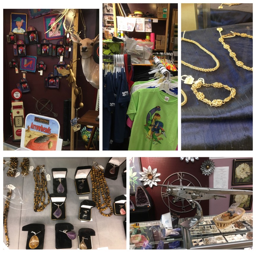
I talked to the staff member and she told me that the store was owned by the local science teacher who was married to the local geologist and in addition to those jobs they had opened this store in town.

IMG_4669

https://goo.gl/maps/EkVQkW8maVH2


Metaphor – Tree of Utah: Wendover, UT

Located just next to I-80, about an hour west of Salt lake City Utah, and maybe 15 minutes east of Wendover, Nevada, I’ve driven by the “Tree of Utah” many times over the years, but this is the first time I ever stopped… and really looked at it IMG_4580
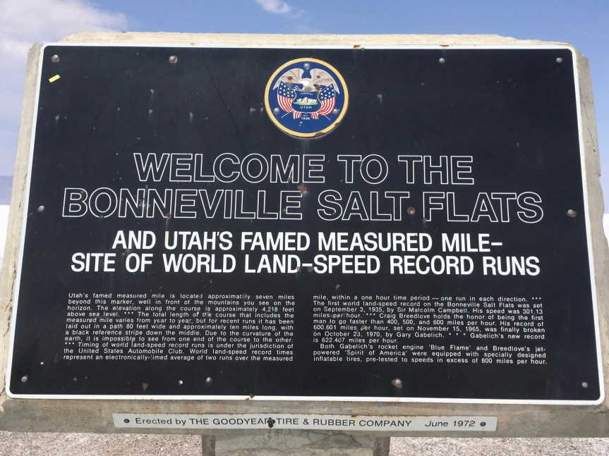
I remember the first time I passed it was like a mirage, as you’re driving through a very large desolate desert area (the Great Salt Lake outside of Salt Lake City Utah) … the sort of place that must have terrified the first settlers in their covered wagons…

IMG_4567

only for this weird alian-like tree to suddenly pop up on the side of the road…IMG_4557

“On a clear day the Tree is visible to travelers on the highway at a distance of 17 miles. Motorists first see the multicolored spheres, as though they are suspended by seemingly invisible means above the desert. In warm weather the trunk is lost in the convection currents of hot air rising from the blanched desert floor.  Only the spheres shimmer mysteriously and silently in the arid atmosphere. On travelling nearer, the trunk becomes visible and the balls are elevated high above the surface, changing hue with the prevailing conditions of light and weather.” — AboutIMG_4571

I.e., now that I’m blogging about, I just discovered that this was in fact the artist’s intention, and it was based on him having just that sort of mirage like experience the first time he drove across that bit of desert.IMG_2333
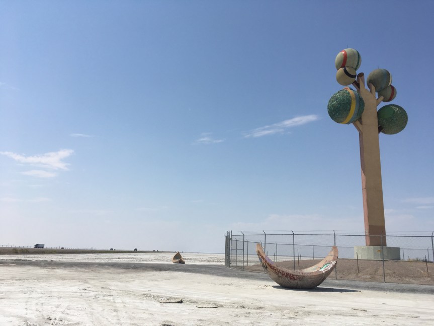
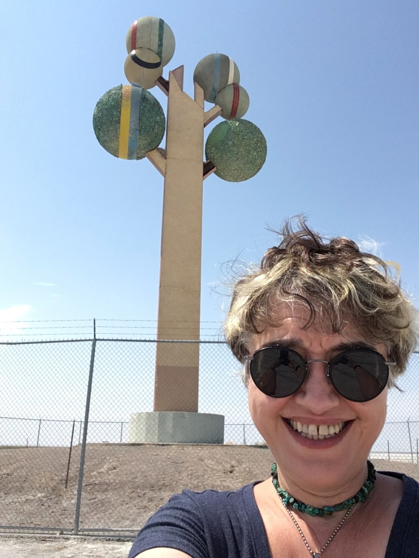
“The tree’s six spheres are all coated with natural rock and minerals found within the state of Utah, and the pods below symbolize the changing of the seasons, when trees naturally transform themselves.” — Wikipedia

IMG_2335

The artist, Karl Momen, built it at his own expense and gifted it to the state. Only when you try to approach it you’re NOT allowed to walk right up to the statue (there’s a fence around it — see above) so from that distance you can only JUST make out the plaque on its side, but can’t really read it… so the artist’s comment is unreadable without powerful binoculars — and the state’s made no attempt to replicate it where you can read it (which kind of tells me something about the state’s relationship to the work).

IMG_2336
I spotted a lot of Rest in peace (RIP) messages written to friends and loved ones on the surrounding salt flats by the placement of small stones

What’s really interesting is if you actually stop your car (which technically you’re NOT supposed to do (I passed a sign that said do not stop for any reason right as I was approaching it… although it’s clear when you get up close and personal that many people disregard that sign)

IMG_2334

is the relationship that locals and travelers have developed with the work. Every one of the “fallen fruit” type things that surround the work are heavily graffitied /tagged

IMG_4573

And individuals have even found ways to put their mark on the fencing that surrounds the work, which are much harder to see from even a few steps away

IMG_4565

After I got back into my car and started to drive, about five minutes more west of the tree I came across this off to the side of the road and stopped…. to give you a sense of its actual size (it was a bit away from me)IMG_2332

The Pink flamingo is the size of pink flamingos that folks tend to put in their front yards… i.e., the green monster is much larger than you think….

P.S., on April 22, 2019 I got this Facebook message from M (not going to put the whole name) “Hi I seen your blog about wendover Nevada,  the green snake monster is something my husband and I built … I was so tickled to see someone had blogged something about it,  we thought instead of seeing nothing but crosses,  grave markers? We wanted to make people laugh,  but we named it bonnie the Bonneville salt flats monster lol we haven’t told a lot of people because we were afraid we’d get in trouble,  [then she wrote something she asked me to keep secret] thanks again for sharing our fun”


Pony Express Station Museum & Gift Shop: Gothenburg, Nebraska

Located in Gothenburg Nebraska is a historic Pony Express Station (well, as it turned out… the walls are original, the roof is new) serving as a museum and gift store. Now granted, it’s not in its original location, historically, it was on the far side of town [they moved it to a park in the middle of town because that was better for business] …. and most of crucial importance, it has no bathroom… But, that said if what you’re looking for is a decent excuse to stretch your legs while road-tripping down I-80, this is it.

IMG_4037

IMG_2306

When I first arrived the exterior of the place met my expectations for a small museum dedicated to the historically important, if short-lived, Pony express

IMG_4031

IMG_3986

Most people don’t realize this but while it’s a favored features of Hollywood Westerns, the Pony express only was in service for about 18 months, partially because only the government or insanely rich people could really afford it…

IMG_2307

“the cost to send a 1ounce (14 g) letter was $5.00[32] at the beginning, (about $130.00 to today’s standards). By the end period of the Pony Express, the price had dropped to $1.00 per ​12 ounce but even that was considered expensive (equivalent to $27 in 2017[33]) just to mail one letter.”
— from Wikipedia, but also told to me by the docent…  and the informational signs they had attached to the walls…

fullsizeoutput_4418

And as I already knew, about 18 month after it began working the first electrical telegraph wires had been set along the same distance, GREATLY reducing the transit time for a message from 10 days by pony express rider

IMG_2305

Who had to ride the whole route on horse back…. albeit from station to station, each time switching to fresh horses

IMG_4012

IMG_4003
the messages were locked into the “Mochila” which were designed to sit over the horse’s saddle, and could then be quickly switched from saddle to saddle, rather than on the person of the riders themselves

to the amount of time it took to send out all the dots and dashes of the message.

IMG_4014

IMG_4021

That said, on closer inspections, mostly what it is, is a gift shop — with over 50% of the space dedicated to sales, and just enough museum pieces thrown in to justify calling it a museum… that and the woman who works there knows just enough about the pony express to give you a short history of it. To be honest was expecting a bit more than this

IMG_4022
EVERYTHING on this side of the building, which is quite tiny anyways, is gift shop

IMG_2303

White King – The World’s Largest Stuffed Polar Bear; Elko, Nevada

This was the one thing I wanted to see while in Elko, which is where I was going to spend the night while road tripping across the US on I-80. White King (the name they give the bear) is supposedly the biggest polar bear ever killed— it was by an Eskimo, and later purchased by the Casino …

IMG_4645

As it turned out the hotel it was in, The Commercial Casino, was JUST across the parking lot from the Ramada (Stockman’s Casino).

IMG_0007
The description below the bear
IMG_4653
The outside of the building

Imagine coming face to face with that out on the ice…. the Eskimo who killed him must have been terrified.

IMG_4649

My first Road runner in the wild!!; Elko & Winnemucca, Nevada

In my whole life I’ve NEVER seen a road runner … well… other than in cartoons or zoos. Today, I think I spotted a few of them….

fullsizeoutput_4444.jpeg

The first one I spotted was in the parking lot of the Stockman Casino (now owned by Ramada) Hotel in Elko Nevada — it’s where I spent the night (that said, REALLY nice hotel rooms at a VERY good price) … I figured it was a road runner because of the tail (which reminded me of the one in the cartoon) and it didn’t seem able to fly much better than a chicken… it flaps and leaves the ground, but doesn’t get very far up.

fullsizeoutput_4446

The next ones I spotted (there was more than one) were smaller, and grey instead of black… maybe a male female thing? Anyway, these were in the parking lot of the gas station I stopped at in Winnemucca (I have always loved the name of that town… say it, Winnemucca)

fullsizeoutput_4445

I love seeing animals in the their natural environment! (well… NOT in cages)

Giant Abraham Lincoln (head) Memorial Monument: Laramie, WY

This rest stop (called Wyoming’s Summit Visitor Center) is located off of the Lincoln Highway aka route-30, aka Interstate-80,

IMG_4251.JPG

and has a very large big bust of President Lincoln’s head, IMG_2270
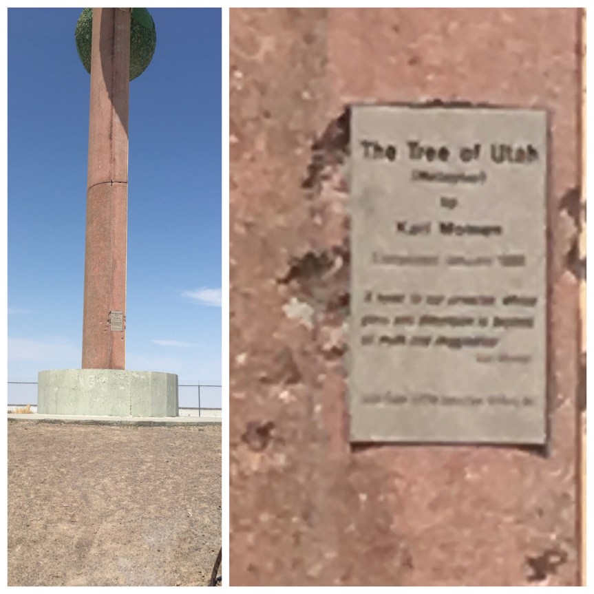
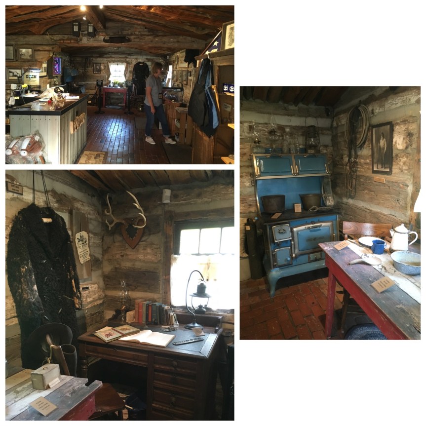
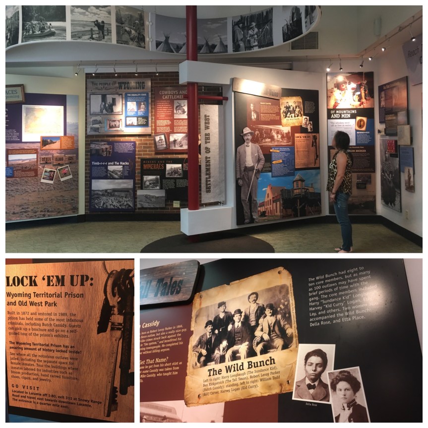
and a small museum devoted to the local attractions, historical and naturalIMG_2269

IMG_2266

IMG_2267
I couldn’t decide whose hair was worse that day, mine or the bears. Note the expression of slight amusement on the bear as he looks at my hair.

And then there’s the information desk where the staff member will help you plan your stay, or provide you with maps and/or pamphlets

IMG_2268

and is definitely worth stopping at when driving cross-country.

IMG_4281

The Lincoln Highway (which begins in New York City’s Times Square, and ends at San Francisco’s Hyde Street Pier) was the first transcontinental (although some of it was laid brick rather than paved concrete) roadway built for automobile use in America. This was back when our highways were given names instead of numbers, and tended to be a series of interlinking two lane roads that sometimes looped (see map) rather than the four lane unimpeded expressways (cross roads either go over or under) built during the Eisenhower Administration as part of our defence system (intended for quick evacuations of cities and troop movements in case of nuclear war).

IMG_4282

Since then the Lincoln was superseded by first Route-30 (two lane roads with intersections), and then Interstate-80. In this part of the country, all three are ONE road.

lincoln highway

IMG_4263

But the main attraction is the Lincoln monument

IMG_2265

IMG_4288