Lunch and a tour: Grand Canyon Caverns;Peach Springs, Arizona

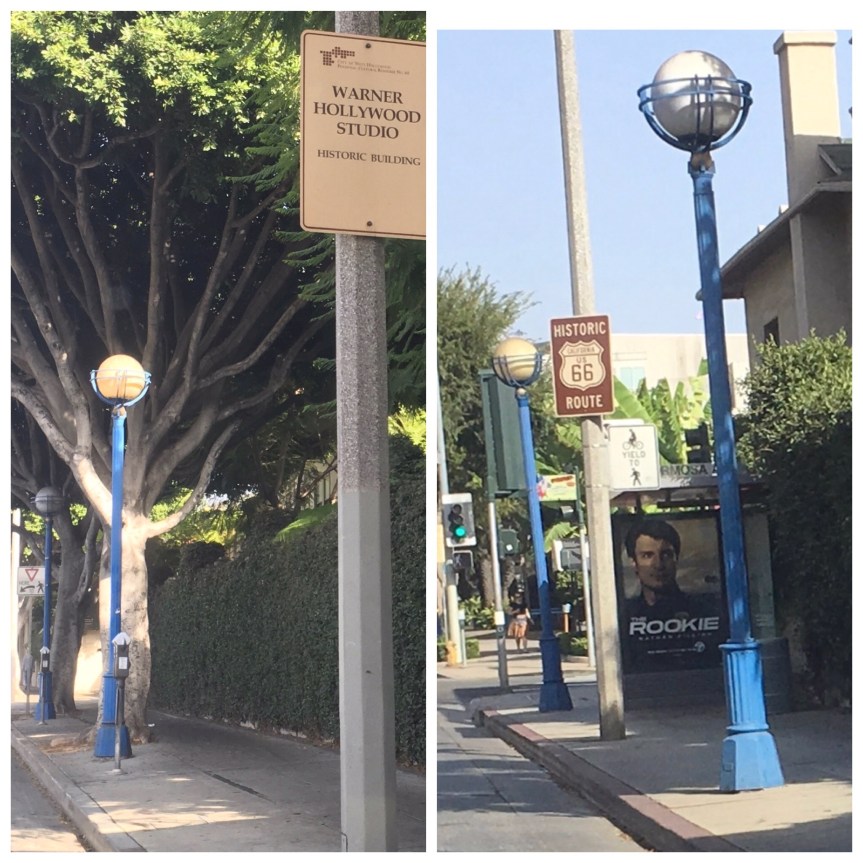
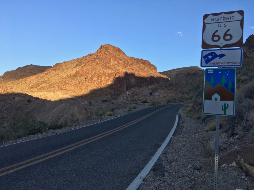
Located just off of Route 66 in either Peach Springs Arizona (according to their website) or Seligman, Arizona (according to Google) is a rather unique tourist trap that’s kind of hard to explain because it can’t really make up its mind what it is.

IMG_7771.jpg

The first thing you’ll encounter is a gas station/laundromat and gift store that calls itself Radiator Springs and claims to be the inspiration for Pixar Movie of the same name. (I have NOT found any external verification of that claim)

fullsizeoutput_49fe.jpegIMG_0243

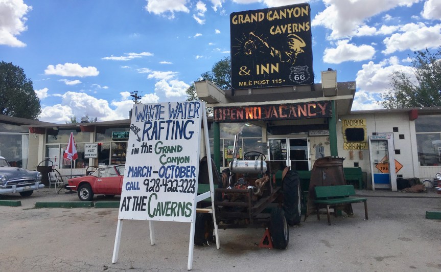
what I was interested in was NOT the gas station, although it was a little cute, what I had come for was about a mile behind the building, via a private road

IMG_7778.jpg

there, above ground, you’ll find a restaurant, motel called the Caverns Inn & RV park, Restaurant and gift-store… but I didn’t take a lot of pictures of that cause it wasn’t what I was there for…

IMG_7780.jpg

IMG_7785.jpg

IMG_7784.jpg
Read the transcription below

In 1927, Walter Peck, a cowboy and woodcutter was walking through this area on his way to a poker game, when he nearly fell into a hole in the ground. The next morning Peck and his friends returned to the hole with lanterns and ropes. Peck was lowered into the hole. He purchased the property and began making preparations for a gold mining operation. Once the assay reports were completed, he learned that his potential mother load was iron oxide. Peck, being an entrepreneur then began charging 25 cents to lower early travelers and explorers down into the caverns. Today travelers worldwide come to visit these dry caverns

IMG_7788.jpg

IMG_7794.jpg

IMG_0244.JPG
The offerings, and the elevator you take to get down there… yes it’s an official fallout shelter

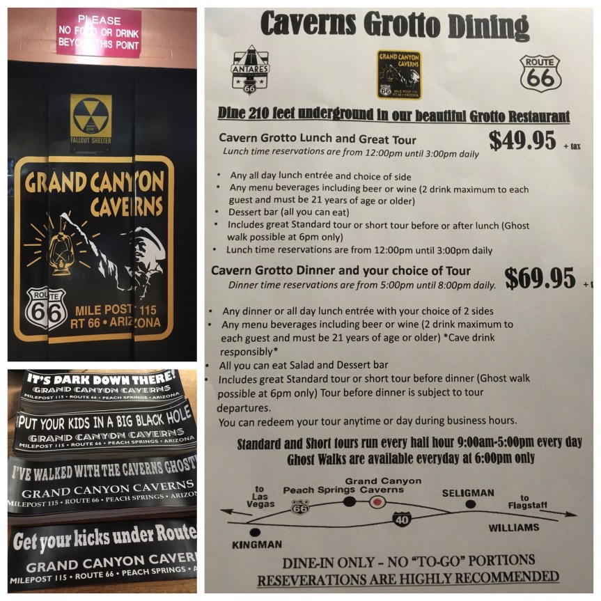
What I was there for, were the aforementioned underground caverns… and more specifically, to eat in the underground restaurant and see the motel (but no I did not stay the night, it costs $975/night. Too rich for my tastes.)


IMG_7779.jpg


IMG_7795
The view of the restaurant from the path to it
IMG_7798.jpg
A view of the restaurant from my table, I managed to get a booking at the last minute


IMG_7796

So there I sat, in the Grand Canyon caverns eating one very expensive grilled chicken sandwich, which was at best, ok… I asked around and pretty much everyone was underwhelmed with their food.

IMG_0246

But, of course what you’re paying for is the view, and the experience

IMG_7802
The view of the cavern from my table, and a group of four people who were touring

I suppose it would have been cheaper if I drank cause you can have 2 glasses of wine, and it comes with all-you-can-eat dessert. But I don’t drink, and I’ve finally managed to lower my blood sugar, and I had places to be later that day… so I must definitely did NOT get my money’s worth in terms of the cost of lunch… in my own opinion. But it was worth doing once… and after lunch came the tour

IMG_0247

IMG_0248

IMG_7823.jpg

IMG_7840.jpg

At this point we ran into a 2nd family which was doing the more “challenging” tour. They were actually climbing through tunnels in the walls, and we ran into them as they were climbing up through one of these deep gaps. (They were wearing helmets with built-in lamps, like what miners wear.)

IMG_0251

And then we watched them climbing UP a staircase that later in the tour we’d be going down (we would ultimately be going up to that same point, but via a gentle twisting slope so that you barely notice it), … in other words our tour was negotiated so as to limit our level of physical effort, while this other group was being made to do it in the most demanding ways possible

IMG_7848.jpg

This is when we got to see the hotel room in the Cavern….

IMG_0249
Two double beds, a bathroom, and a big screen TV, and along side it a stone dog to protect you

IMG_7842.jpg

This is a location where they hold weddings, it is up the slope from the hotel room (a little stage and rows of seating; if you look past the stage area you see the big screen TV very clearly, and the wall that it’s held up by is for privacy in the bathroom…

Much Later, after we finally came back DOWN the stairway the others had gone up, (I’m jumping forward, but will cut back after) we were led to the opposite side of this same ‘auditorium’ where we saw these…

IMG_0252.JPGThe chairs used for 60 years in the American Film Institute in Hollywood and when they replaced, the caverns bought them. So your guests at your wedding can sit in chairs that MAY have had very famous movie stars and directors sitting in them at one point.

So, back to the tour…. After we first saw the hotel room and the wedding venue, we walked along the path to the Fall-out Shelter storage area of the cavern.

fullsizeoutput_4a23

=IMG_7858.jpg

IMG_7861.jpg

We walked through the winding paths of the cavern, and came to a low ceiling point where everyone but me had to stoop to pass it… the d

IMG_7862.jpg

IMG_7864

IMG_0255.JPG

The mystery room (upper right corner, above) is called as such because fresh air comes into the cave, but scientists have not been able to verify how. They do know it is coming in from there… but not how it’s getting into there… hence the mystery. There are apparently special tours you can take that take like 5 hours, where you can go spelunking into that part of the cave…. but it’s only for serious caving people

Once we got up to the top we began to going down, via a path that took us OVER the stored supplies for the fall-out shelter

IMG_7878.jpg

Apparently when they brought in the pallets, they forgot to measure the size of the pallets versus the size of the entrances… and found they had to take all the supplies OFF them, bring them in, then reload them back on to them.

IMG_0256.JPG
I particularly loved the giant sloth figure, apparently they found the bones of one in the cave

At the end of the tour, which took a little over an hour …. the Dutch visitors who were in my tour group started telling me how much they loved Trump, and how they’d have voted for them if they were Americans…
no words


Getting your kicks on route 66, the greater LA area edition

I have begun my route 66 road trip!!! Only, I’m doing it backwards from California rather than starting in chicago like the song does.

Rather than beginning it on the Santa Monica Pier, which is where the powers that be want you to begin, I started my trek on the 2nd historic beginning of the route (the furthest end point). Namely, I started on the corner of Lincoln and Olympic Blvd — adjacent to the freeway, and a walking distance from the pier. That said, I could not find any markers there…. (I THINK there may be two Lincolns and Olympics, one on either side of the freeway, with Lincoln being one way on each side… the sign MAY have been on the other side.)

IMG_7183.JPG

That said, the ORIGINAL ending point didn’t make it past the corner of 7th and Broadway in downtown Los Angeles. It only extended to Santa Monica as the greater LA area grew, with Santa Monica being a desirable location to live and downtown LA degenerating into a massive skid row (There are over 60,000 homeless living in LA county, and they’ve created a tent city in downtown LA takes over 50 square blocks, HUGE! With only nine toilets per 2,000 people…. If you’ve never seen it, I suggest watching this video)

This is clearly NOT what tourism officials want tourists focusing on… So Santa Monica is a MUCH nicer start….  I made my way to the Pier in order to get the “tourist” aspect

IMG_0134.JPG

This couple from Germany was just finishing up their Route 66 trip, and were strongly advising this book to me, which this shop called 66-To-Cali had for sale… I gave it a look. I think it’s more useful if you have TWO people and one person can follow the book giving directions to the driver. So, not so good for me. I HAD wanted to buy the California 66 end of the trail T-shirt but they run VERY SMALL and they didn’t have one my size.

A video I took while there

IMG_7201

Then I started the drive, stopping to take snaps of various “Historic 66” signs along the way…

fullsizeoutput_481d
14th & Santa Monica Blvd, in Santa Monica
fullsizeoutput_481f
S. Carmalina Ave & Santa Monica Blvd in LA
fullsizeoutput_4800
Cafe 50’s on Santa Monica Blvd/W. Historic Rt 66 in LA

Then I hit, BEVERLY HILLS!!!!

fullsizeoutput_4821
Santa Monica Blvd and Wilshire Blvd, in Beverly Hills
IMG_7227.jpg
Church of the Good Shepherd/W. Historic Rt 66, Beverly Hills
IMG_7234
“In Beverly Hills? Rodeo Drive BABY!” — Pretty Woman

Me in front of Beverly Hills Building & Safety/Police Building… and a picture of the nice Japanese couple who took the picture for me

fullsizeoutput_49db.jpeg
On W. Historic Rt 66, Beverly Hills

IMG_0138

IMG_7261
Maple Drive & Santa Monica Blvd in Beverly Hills
IMG_0877
various locations on Santa Monica Blvd/W. Historic Rt 66, West Hollywood
IMG_7279
Santa Monica Blvd/W. Historic Rt 66, West Hollywood
IMG_0141.JPG
Santa Monica Blvd, West Hollywood (two ends of the same block)
IMG_7284.jpg
Alvarado & Sunset Blvd, Los Angeles
IMG_7287
Sunset Blvd, crossing the bridge over Arroyo Seco Parkway, in Los Angeles (near Dodgers Stadium)

So far for the MOST part I managed to stay on the road with one hick-up when approaching Pasadena where I got off the Arroyo Seco Parkway (110/66) too early…. which is sad because it turns right into Route 66 at its end.

IMG_0878

I had used Google maps to chart out 66, then found landmark addresses (some of them just being local business of no import) and plugged them in … problem is I think I ultimately plugged it into my GPS system wrong because of two very similarly named roads (Blvd vs St. vs Rd type issues).

IMG_7300
U.S. Post office on E. Colorado Blvd/W. Historic Rt 66 in Pasadena
IMG_7304
Near the corner of E. Colorado Blvd and S. Lake Ave in ‎⁨Pasadena

IMG_7305

The view of the mountains north of Pasadena from E. Colorado Blvd/W. Historic Rt 66 near N. Hill Ave

IMG_7308
Saga Motor Hotel, E. Colorado Blvd/W. Historic Rt 66, Pasadena
IMG_7309
E. Colorado Blvd, just past Madre Street
IMG_7310
E Colorado Blvd/W. Historic Rt 66, Pasadena,

IMG_7311

This sign was on E. Colorado Blvd Arcadia, in front of Coco’s Bakery Restaurant (I used their rest room)

IMG_7312
Entrance to the Santa Anita Race Track on Colorado Pl/W. Historic Rt 66, Arcadia
IMG_7313
E. Huntington Drive and 1st Ave, Arcadia
IMG_7314
Huntington Drive and 2nd Ave in Arcadia, a Railroad bridge
IMG_7315
W. Huntington Ave & S. Mayflower Ave in Monrovia

There’s a Costco directly on route 66, 1220 W Foothill Blvd, Azusa, CA ….got a love it, of course I filled up on gas, used the bathroom, etc.

IMG_7316
890 E Alosta Ave, Azusa
IMG_7318
1832 E Rte 66, Glendora
IMG_7319
E Rte 66 & Amelia Ave, Glendora

At this point it was getting dark, and my stop for the night was at the historic Wigwam Motel in San Bernardino — see the blog post about that — which is family owned and if you don’t get there by 8pm you need to call and tell them or they’ll give away your room, and you’re expected to show up at a decent hour… so I stopped taking photos and just drove the next 40 minutes with no stops

IMG_0876

And then, after I checked in, I went to get my dinner in San Bernardino was a place that had the most reviews/highest— it was an all day breakfast with dinner till 10pm. Everything I had tasted homemade —Corky’s Open 24 Hrs Rialto, CA

IMG_0816.JPG

One warning… including stops it took 6.5 hours to drive from Santa Monica to San Bernardino … I was expecting it to be 4 hours, i.e., WAY longer than I thought it would, or google said it would take, to get from Santa Monica to San Bernardino

66

The Arizona divide and some highway luck

The Arizona Divide is on Route 66/I-40, and is located just west of Flagstaff, Arizona. It is a geographic location marking the point where water either flows toward the Colorado River watershed or to the Gila River watershed

IMG_8352.JPG

As I was headed towards Flagstaff I hit a massive traffic-jam.

IMG_0007

Somehow, a truck had overturned, and if you look at the photo you can sort of see that there’s a huge crane parked in the middle of the highway trying to right the truck and all the traffic has been redirected into a single file that passed it by riding on the highway’s curb/pull over section.

fullsizeoutput_49aa
Soon after I passed the accident I spotted the sign and I pulled to the side of the road to take this photo of the sign marking the divide’s location IMG_0008

A minute or two later, I realized that no more cars were driving past me. The road was COMPLETELY empty and stayed so for I don’t know how long, because I only hung around about 5 minutes before heading towards Flagstaff. I wasn’t driving very fast, and after a bit pulled over again, wondering when the traffic would flow… and took more photos — and even watched a train head towards me and pass under the highway

IMG_0009I.e., I was VERY lucky in passing it when I did cause I could have been sitting there MUCH longer/

IMG_8359

Burnt Earth: Amboy Crater in Amboy California & Pisgah Crater in Newberry Springs, CA

When you drive through this part of the country, be it on Route 66 or even on 40, you can’t help but notice the sudden appearance of pitch black rocks everywhere that look like giant bits of coal, or chunks of burnt wood.

IMG_7502.jpg

IMG_7960.JPG
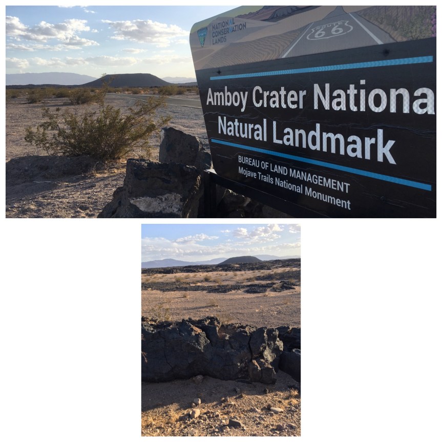
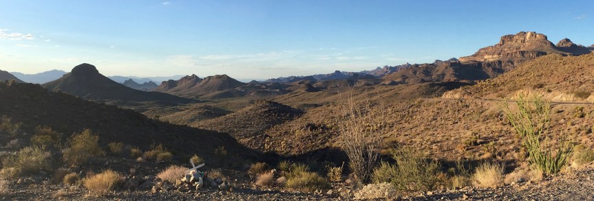
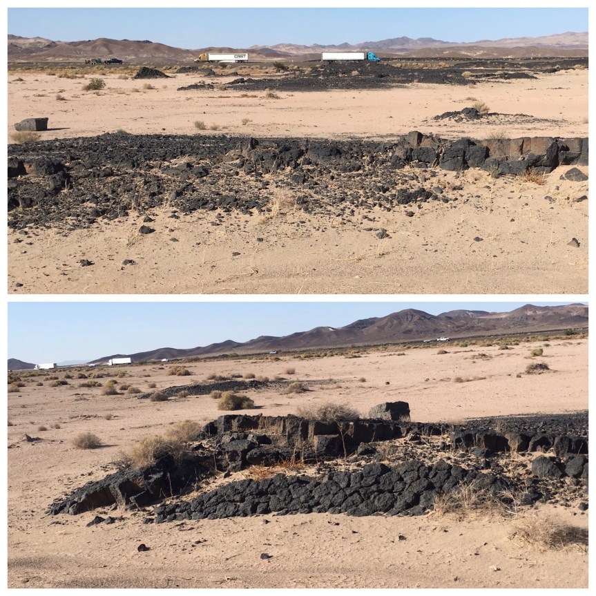
The first time I drove through here it was with a friend from university who has been a geology major, and he explained to me how these rocks were the result of lava rivers… but ones that exist well below the ground, but close enough to the surface that the heat from them had in fact burnt the ground above it. So it’s not lava but actually burn rocks (or at least I think that’s what he said… this was like 20 years ago)

IMG_7961.JPGYou can see how the ground looks sort of burnt and cracked, like really badly burned wood, or food. Well within in this general area are TWO craters that rise well above the ground, and are actually evidence of Volcanic activity, i.e., those underground rivers of lava actually making it to the surface and trying to create mini volcanos —- or at least that’s how I sort of understand it… I’m no geologist.

Driving east on route 66 the first of these that you will pass is the Pisgah Crater

IMG_7517.jpg

IMG_7962.JPG

The other crater is the Amboy Crater… not much farther east (maybe another half hour…)

IMG_7959.JPG

I didn’t have time nor did I feel comfortable approaching these craters alone. I would LOVE at some point in the future to go there… but I would want to do either with a guide, or at the very least a friend. Being stuck out in the middle of no-where, in the heat of the desert…  all alone… did not appeal to me (should the car get stuck, or blow a tire or something)

Roy’s Motel & Cafe; Ambroy, CA

Roy’s Motel and cafe located in Amboy California isn’t actually something that, if it were located anywhere else, you might look twice at…

IMG_7540

…. at least for that fact that it’s location against the stark beauty of the Mojave Desert makes it somewhat wondrous when you first see it.IMG_7707IMG_7550

IMG_7708.JPG

According to Wikipedia the “historic site is an example of roadside Mid-Century Modern Googie architecture” and is under the stewardship of a private  conservationist — Albert Okura, the same guy who owns and runs the Original McDonald’s in San Bernardino, California which I also visited … well it would half to be. I doubt it’s highly profitable.

IMG_7548.JPG


The moon in the night sky, Kingman Arizona

I took these photos of the moon as I was driving back on route 66 to my hotel… this was my 2nd day in Kingman while I was backtracking to pick up some of what I had lost the day before (the route from Needles California to Kingman Arizona).

IMG_7679.jpg

The moon was almost full, and because of being out in the middle of nothing, with no electric lights lighting up the sky, it seemed even brighter than I was used to, and the camera in my iPhone was able to actually pick it up in the evening sky

It was take about in this location… but on the other side of I-40 and looking towards away from the highway

Sitgreaves Pass – Rte 66, Kingman Arizona

By the time I got to my 2nd day of Driving down route 66 … well let’s just there are only so many 66 signs you can see before they start to get a little tired of them… and more than a few of the ‘must sees’ you begin to realize would be less exciting if they were anywhere else. This can not be said for little bit of road. It’s the bit of 66 that connects Needles California to Kingman Arizona

IMG_7582.JPG

IMG_7583.JPG

IMG_7581

Not sure there’s much to say… but so so beautiful… it’s a very twisty pass that route 66 takes up and over a hill, and the wise don’t do it faster than 30 mph… and you wouldn’t want to anyway because every turn takes your breath away

IMG_7631.jpg

IMG_7641

IMG_7639

IMG_7650

IMG_7654

IMG_7660

Although, after having driven it you understand why I-40 couldn’t have followed Route 66’s location at this point and had to cut a wide-berth of it


Lunch with old friends: Hermosa Beach⁩, ⁨California

Had lunch with one of my oldest friends (we’ve known each other since we were in diapers) and his fiancé. I wanted to go to the beach so they took me to this place called “The Good Stuff Restaurant” in the city of Hermosa Beach

IMG_6702.JPG

It’s mostly an all day breakfast sort of place with lots of healthy options. Apparently (I learned while writing this) it’s a local LA chain, with four branches. I got a strawberry smoothie with protein powder and a Greek omelet.

IMG_6674

Not the best Greek Omelet I’ve ever had, but quite tasty. They use good feta, but it was a bit too oily … and they offer a choice of potatoes or fruit… we all opted for the fruit. That said, it did have great views of the Ocean while we ate.

IMG_0484

After lunch we walked out on to the pier and came across this….IMG_0485

… a photographer doing a photo shoot about how we have to do a better job of recycling. Apparently 69% of our garbage ends up in landfills or in the oceans.

IMG_0488

and then we went further out, enjoying the seaside and looking at the surfers

IMG_0487

All along the pier there were a bunch of fishermen, and this guy was holding out a piece of fish to a seagull, another fisherman said that I might not believe him but that particular seagull was the first man’s friend, and always ate out of his hand

IMG_0489UNFORTUNATELY I didn’t manage to get a shot of the seagull actually eating out of the man’s hand, but he did!!!

IMG_6688
A sign warning the fishermen which fish to throw back

IMG_0483
When we got to the end of the pier we spotted this seal, swimming among the fisherman’s lines, like he was trying to get fish off the lines, or steal their catches

IMG_0490

Pacifica State Beach, California

Meeting up with an old friend I haven’t seen in years…. I will say this about the Bay Area… if you don’t like the weather drive 15 minuets, it’ll change. I was staying at the home of another old friend in the South Bay area, and drove north to Pacifica, which is right next to the ocean. We met at her home, had a long chat and then walked the TWO blocks (yes life is hard for some people) to the sea-side.

IMG_5101

The temps in Sunnyvale (which is in the South bay) were 77 F when I left about an hour ago, here in Pacifica it’s 64 … this difference is because of the fog that coats the place almost none stop during the summer months

IMG_5103

There was a group of whales out there— we kept seeing multiple poofs of water as they spouted….. and then I saw the whale’s back out in the distance, for just a second… and we kept watching and then saw jumping whales and their heads as they tried to scoop up the fish and then their tails when they dove back in—- but it was so far out in the ocean that I seriously doubted that my little iPhone camera picked up anything — and it didn’t

IMG_0093.JPG

Just at the edge of the seashore was this statue:

IMG_0092

Captain Don Gaspar De Portola
born in Balaguer, Catalonia, Spain
First Governor of California
Founder of San Diego and Monterey
Discoverer of the Bay of San Francisco on November 4, 1769
Presented by the President of the Generalitat of Catalonia
The Honorable Jordi Pujol on November 5, 1988
To the People of the State of California
The honorable George Deukmejian Governor

IMG_5094
Me and my old friend, believe it or not we used to wear the same size clothes

That said, on the way back, my Subaru saved my life again today… was tired, driving home from Pacifica, didn’t notice cars in front of me on the highway suddenly slowing down, my car threw on the brakes and set off alarms, I threw the brakes on harder…. a tour bus was on the side of the road with the door to the luggage area completely open blocking a lane of traffic….

And then, when I got home to my friend’s house, where I’m staying… I found the family in bathing suits… “we’re going to go hot tub, care to join us?” My first soak in a hot tub in about a year — life in California is so hard

Golden Gate Bridge & Muir Woods: San Francisco Bay area, California

Hello from SF. After Pennsic I spent the last two weeks road tripping across America on I-80, in large part so that I could attend the 50th wedding anniversary of two dear friends (and former employers) of mine, up near the north/east end of Maine county (north of San Francisco). I had booked an Airbnb up as near to the venue for the party as possible, a local restaurant called Rancho Nicasio (apparently they’re popular for weddings too) — which I have got to say put on an impressive event.. and then made plans to stay with various friends who lived down in the south bay (which is about an hour and a half drive south of the party).

The next day I intended to take advantage of that location and go to Muir woods, which was one of my favorite places back when I used to live in Marine, only to discover that just a few months ago they instituted a reserved parking rule. You now have to book your visit 90 days in advance!!!! Either that or you have to do it 5 days in advance which means you’ll only get access to the handful of spaces that they’ve held back. The night before I got on-line and found that ALL the spaces were booked up till 4:30 in the afternoon.

That said, APPARENTLY, probably because Muir woods was someplace I went to every few weeks back before iPhones were even a product (I think I was still using palm pilot back then) — I do not have any digital photos of the place:

So instead I was like, “oh, I’ll just stop by the Golden Gate and get photos there… but normal daily fog (especially in summer when the air is hot and water is cold) had rolled in a bit early and very thickly (it was just noon, usually it wouldn’t be quite this thick till 1 or 2pm)… so I didn’t bother taking the time to pull over, and this was all I managed to snap:

IMG_5024 So I am posting photos from a 2005 visit (which apparently I do have a few of — would have taken them with a digital camera) but back before the selfi was a thing:

IMG_2428.JPG