The personal authentic travels of a world-wide drifter, you'll always see pics of me at the locations being described (if the other blogs you're reading don't do that, odds are they were NEVER there, just saying…)
Fact is, there’s not much to see on Vancouver Island OTHER than mother nature, this is one of those sites.
The tide is out — Tom and I walked most of the way out; the sand was full of these really pretty purple shells, and families were out there, some seemed to be digging for clams… but then when we got close to where the beach ended I started having stomach cramps which in my world means time to find a bathroom — but quick, ah the joys of being me.
That said, leaving the park and heading north along our proscribed path we quickly found that Tim Horton’s a Canadian doughnut chain type place has not only has clean bathrooms but coffee and sandwiches that give McD’s a serious run for their money.
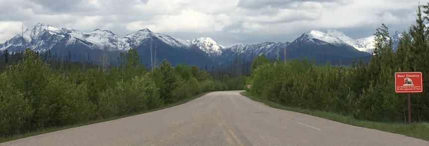
I spent most of today traveling the Trans-Canada Highway from Banff National park to Kamloops, where I had booked a highly affordable night’s stay via Airbnb (and which took me a good 6 hours to drive) I passed though two national parks… Yoho National Park and Canadian end of Glacier National Park. Suffice it to say it’s a gorgeous drive.
One of the things I loved seeing along the way were the high fences along the high ways along with regular animal overpasses (bridge on the right) — we really need to start building these in the states.
There are also rest and picnic stops all along the route at scenic spots (with toilets!)
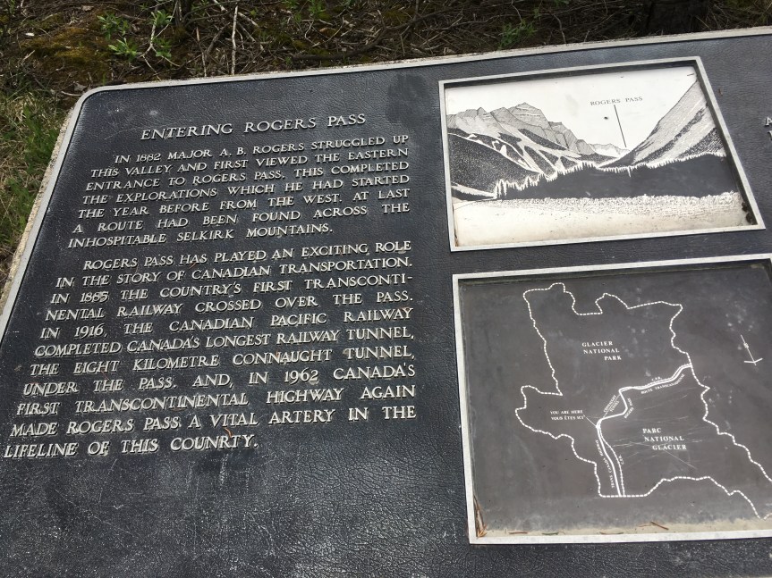
And then I passed through Roger’s Pass… which is in the heart of Canada’s half of the Glacier National Park
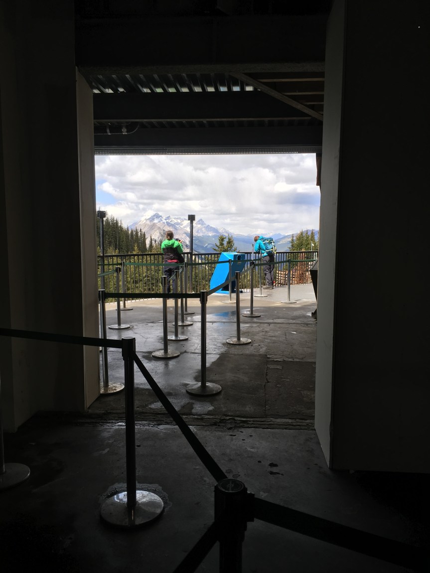
Even if you only have time for a quick drive through on your way to somewhere else via Canada’s Highway 1 (like I did), it is TOTALLY worth it to pitstop at Banff National Park’s Gondola for a ride up the mountain ($42 for adults, $21 for kids);
Every time I told anyone what my plans were for this summer, the one thing I heard almost everyone say was, “well of course you HAVE to stop in Banff” and now I know why. Banff is a cute, very touristy little town located in the middle of a national park, of the same name and just to the side of Canada’s Highway 1. It is, in a word, gorgeous. I was there in the last week of May, in a winter so warm and dry that Canada was having wild fires, and the mountains were still snow peaked.
From the town to where the Gondola is, is about a stunning 10 minute, very well marked drive (even without my GPS I would have found it. Once there, If you want to get to the top of the mountain you can of course, always hike up it, like these folks are doing….
Or you can pay what initially seems like a hefty $42/adult to take the Gondola, a choice I did not regret once I was in it — they allowed me to ride alone.
When you get to the top (which is not really handicapped accessible) there is a wooden walkway with strong railings that extends all the way to next peak (with a lot of up and down staircases along the way), which I did not take; in part because I’m a wuss, but also because I knew I had a good six hours of driving ahead of me and it would not be safe to exhaust myself (no really, it isn’t just an excuse). If you do choose to do it, you need not worry about doing it alone, I would argue that MOST of the folks opted to do the full hike.
I however choose to just hang out near the arrival building. When I was there it was under construction, but usually it contains a restaurant, bathrooms, a gift shop, etc. While we didn’t see much wildlife up there, there was some:
There was this one very ballsy chipmunk, he came right up to one woman who was sitting on a bench and sat next to her, then she saw him and freaked — then he kept approaching folks hoping for food — And then there were mountain goats who seemed to prefer to hang out under the walkway, which I assume provided them some protection from predators who didn’t like the sound and smells of all the humans.
Then, when you’re ready to go down they take a picture of you as you renter the gondola, which they then try to sell you a print of (they aren’t able sell the digital image) photoshopped really badly into a cheesy looking background.
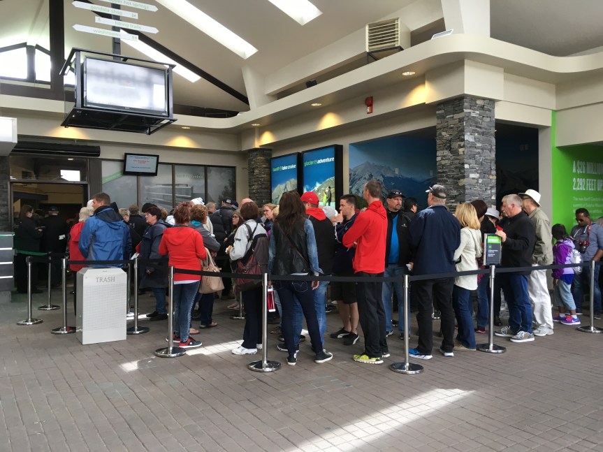
I will say this, apparently I came at the right time, because there was no line at all, either when I bought my ticket, or decided to finally take the ride up (after a bathroom break and checking out the gift store, etc.); however, when I got to the bottom, this is what I saw:
and it kept going all the way down the hallway.
That said, I think it’s important to try to time around bus tours. When I first got there I saw three large tour busses loading up and heading away, and then I think all of these guys were dropped off while I was coming down. Don’t wait in a line like this, have a cup of coffee, troll the gift shop, and wait for it to shrink.
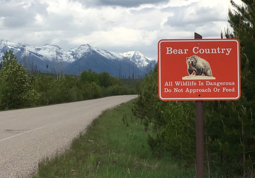
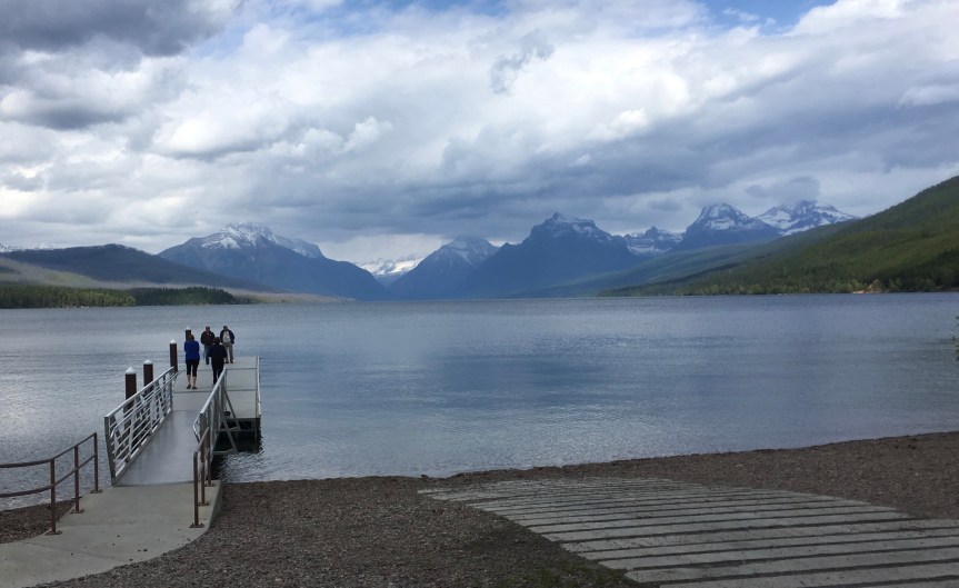
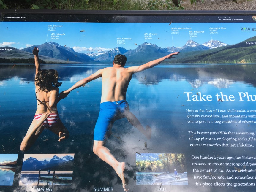
Glacier National Park is HUGE, as in you can’t really see and enjoy the whole place in one day, not even if you’re going to do the whole thing by car. It is just too big. This was my second day, when I explored the western half… and then wished I’d allowed myself a full week at the place.
Warning: If you arrive at the park early in the season (I was there at the very end of May) the “Going to the Sun” drive which connects the east and west segments and travels through the middle of the park will most likely STILL be blocked with snow. If it is you’ll be forced — as I was– to leave the park and circle around via lower altitude roads.
I learned later that the full road isn’t actually opened until LATE June or even mid July, depending on weather conditions — there is even a web page dedicated to updating tourists about how much of it the plows have opened for traffic. Apparently about Oct. 16th is when the road closes down again because of expected snow accumulation… one of these days I will go there again in September after the kids are back in school so I can drive through the highest elevation parts…
I stayed two nights at Brownies Youth Hostel and Restaurant, which is near the eastern side of the park. I had found it via Airbnb, but had then contacted them directly and made the booking by phone in order to ensure that I got the specific room I wanted (a private and across the hall from the ladies bathroom). It was the ONLY Airbnb near where I wanted to be, as close to the park as possible but not far off the highway I was going to take up to Calgary, and every hotel I found in that same area (note: I was not yet truly skilled in the ways of finding high quality mom and pop motels yet, so this price was compared to the larger hotels, etc) were asking WAY more than I wanted to pay. Here at the hostel, a bunk-bed in a shared dorm room is $22/night, and a private room with a double bed is $65 — utterly reasonable prices. I really enjoyed my stay there and met a bunch of really nice college kids who were roughing it, as well as a really nice married Indian couple who were both young professors (one taught business, the other psychology).
My bedroom at Brownies
I will say the only unexpected (it is a hostel and not a hotel) downsides of Brownies were 1) the WiFi in my bedroom sucked to the point of useless; the modem was down the hall where the shared spaces were — kitchen and living room and was good and fast there, but the signal just didn’t really reach to my room. And, 2) while the rustic log cabin walls were cute and provided visual privacy, they resulted in small gaps between the interior and exterior walls with the result that they did not block noises from the other rooms pretty much at all. This would not really have been a problem were it not for the fact that the college dude sleeping in the bed on the other side of it had a snore like a freight train (thank the lord I ALWAYS travel with an ample supply of top of the line ear plugs). He was in a group of guys who were bicycling their way across America (raising money along the way), and we all kidded him about he’d have to do something about that snore if he ever wanted to get and stay married.
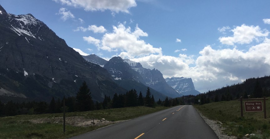
After breakfast I headed around south and then west along route 2 through the Marias Pass to the other end of the “Going to the Sun” road, which I had not been able to reach the yesterday due to snow and ice still blocking the roads at the higher elevations.
So, on the way there I passed through the Louise & Clark National forest, which is yet ANOTHER stop of the Louise & Clark trail… and get this, it’s May 28th, and it is SNOWING! (no wonder the higher elevations are still blocked with snow). Off to the side of the road there was an area with two big memorials, and one tiny one:
The obelisk is a memorial to Teddy Roosevelt, constructed in 1931Note the Cargo Train running behind the statue
This statue is in memory of John F. Stevens (25 April 1853 – 2 June 1943), an American civil engineer who helped to build both the great Northern Railroad and the Panama Canal, [the following is according to the highly faded and barely legible sign that was standing in front of him, sad] “was charged finding a suitable rail route across the Continental Divide. In December of 1889, Stevens located and recorded the pass which had been used by area Native Americans for many centuries” i.e., what came to be known as Marias Pass.
There was also a third, very small memorial … just a big chunk of pink rock with a plaque embedded into it which I actually found kind of touching:
There’s a story (found it on the cite I linked to Morrison’s name, see below)), about how “John F. Stevens, credited by the Great Northern Railroad with the discovery of Marias Pass, spoke at the dedication of the Stevens statue at Summit. In the course of his speech, Stevens told of hardships in searching out the pass over the Continental Divide. He explained that it was December, and he had nearly perished in a blizzard at the pass. At this point, Morrison spoke up from the crowd: “Why didn’t you come over to my house? I was living right over there,” he said, pointing to his cabin.” — makes me smile
Again, there was a very faded sign in front of the memorial (that was even LESS legible than the last one) with more information:
“William H. “Slippery Bill” Morrison was a mountain man who had “squatters rights” on 160 acres at the Marias Pass summit. He donated a portion of his land for the site of the Theodore Roosevelt Memorial monument.
Morrison was a frontier philosopher who would often expound on his favorite theories to anyone who would listen. Morrison spent most of his life as a trapper and prospector.
Slippery Bill diet in 1932 at the age of 84. According to his wishes the balance of his land was transferred to the federal government after his death.”
All of which was followed by a very faded sketch of the old guy:
As I approached the park, firstly I realized that there were way more people here than had been at the other end of the park, and second — after driving over an hour to get here — I realized I had better fill up before entering the West Glacier Park entrance, because those places almost never have gas stations inside the park boundaries. Also, it was SO FRIGGING COLD (may 28th and it was SNOWING) that I decided to try to unload my trunk and dig out the down coat, winter hat and gloves that I had buried in the compartment designed for the spare wheel.
Granted, this made them kind of inaccessible, but they were there for emergencies just like this one. My overall goal with these trips is to structure my movements so as to never need see full winter, but, that said I had had the forethought to bring them just in case. Let’s face it, even southern Florida occasionally gets a cold snap. I also lug around a big thick down blanket in the backseat of my car, for the same reason, and have had a few days when I needed it. My car actually is loaded with food (nuts, olives, etc), loads of water, and a heavy down blanket just in case the car should happen to break down in the middle of no where on a cold night. Yes, I’m a planner.
Anyway, since my massive suitcases were still in there, and I needed help in order to remove them, I spotted a guy standing off to the side with a handful of papers and called him over asking him to help me. Turned out his name was John Marshall and he was from the University of Montana and was doing a research questionnaire about tourism at the park, and in exchange for my scratching his back (answering the very long questionnaire) he helped me unload and then reload my car, and we got to talking…
As we were talking the question of the local Blackfeet population came up (I forget why), and I told him about the heavily graffiti-ed obelisk I had passed on the way to my hostel, just the day before; so, he was the one actually gave me the heads up about the confrontational history between the local tribes and Louis & Clark; and he was also the one who told me to look up Elouise Cobell, and how she had brought a case titled, Cobell v. Babbittagainst the United states Department of Interior based on her own investigation of their practices (that she said “revealed mismanagement, ineptness, dishonesty, and delay of federal officials”of Indian trust assets … money owned by the government but held in trust for Native Americans… to the tune of $176 billion).
Apparently he had not long before attended her funeral, so she was active in his mind — and I got so distracted in talking to him that when I finally got into the park I realized that in all that moving, packing and talking that I had completely forgotten to actually pump any gas. So I had to leave the park after having just entered (yay for my National parks pass) to go get gas (again). At which point I realized it was already lunch time, and that I was hungry …. so I stopped at the West Glacier Restaurant and got myself an elk sausage (seriously, elk!), tomato Florentine soup and cup of a huckleberry tea (am saving room for more huckleberry pie for tonight) — it was supposed to be served in a kaiser roll type thing but I asked them to hold the carbs, and the french fries, and give me more veggies instead
And then FINALLY I got into the park!
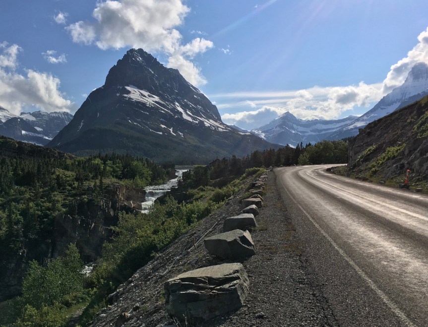
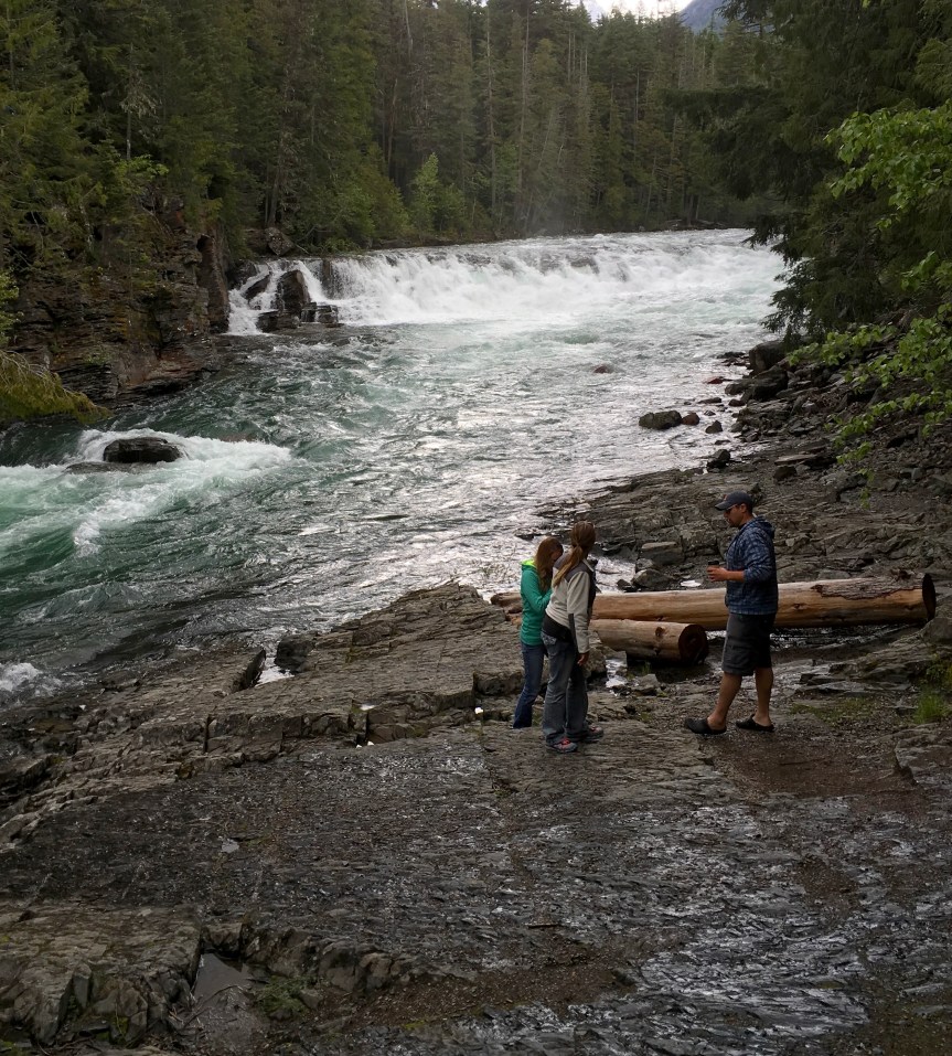
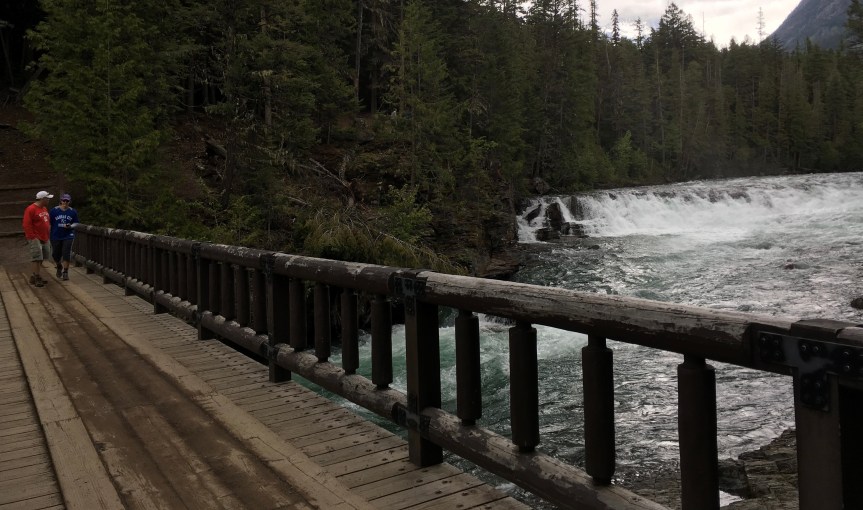
Leading off of the lake and up into the mountains is this river, which is full of a lot of picturesque twists and turns, and rapids, etc… which the “Road to the Sun” follows alongside of, heading up into the mountains… or at least at this time of year up until the road conditions become unsafe….
and multiple times along the river you come to narrow bridges you can often drive across, but at the other side you usually find some limited parking and hiking trails (of course with my painful hips, knees, and plantar fasciitis — feet — this was not something I was going to do, that and I didn’t have proper hiking boots, just a pair of Crocs, because of the plantar fasciitis).
As I traveled around the park I kept running into this film crew who said they worked for a German TV station, they had this big red van and sometimes sometimes would prop the cameraman and his rig up over the top of at… the last time I saw them was when I was about to leave, and a park cop and pulled them over, lights and all, which made me think that maybe they didn’t have the proper permits… either that or he wasn’t pleased to see the cameraman perched on their hood
At one point I came to this place, where there were all sorts of cars parked to one side, only there was no parking for me, so I parked as far off the road as I could on the side where there was no designated parking (hoping it wouldn’t earn me a ticket. When I initially parked here I was the only car not on the side with designated parking spot, but instead on the wrong side of the road pulled off to the side as much as possible… I came back five minutes later seven cars (two not visible) had already followed my lead
I kept driving up as far as I could, but about 45 minutes in, as the elevation started to rise, snow and sleet started to come down, I had started to approach, but hadn’t gotten anywhere near the area called
At this point the weather was definitively nasty (I actually ran into one of my fellow youth Hostel guests up there), and there was a massive road block… so there was no choice but to return the way I had come… only this time I took one of the many side roads that led back around the lake to the other side
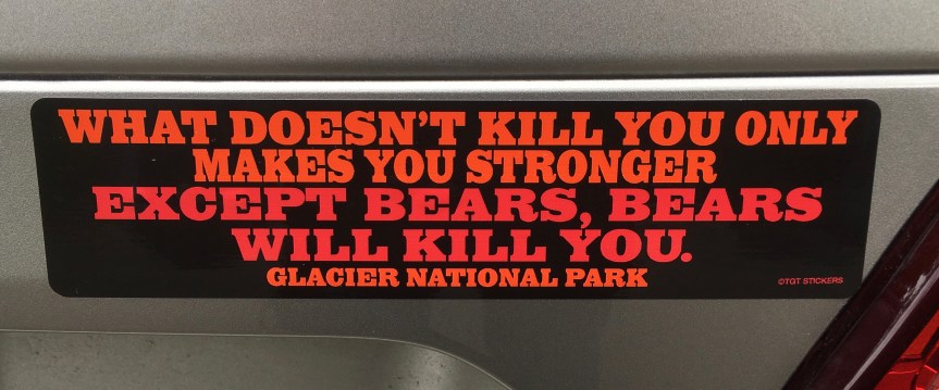
After driving around a while I came to a section of the park that was all shops and restaurants, and a hotel complex within the park for visitors. In one of the shops I found this, and … well…. my new car is in dire need of some new bumper stickers:
I am the proud owner of a new bumper sticker!
Finally, I headed home and after stopping off for dinner, where I got myself that piece of Huckleberry pie, I headed back to the Hostel, at which point I realized that it was 10 pm and it is still light out… WTF?! How far North am I?
Glacier National Park, US or Canada should be on everyone’s bucket list, it’s AWE inspiring. That said, consider your dates of arrival carefully because if you come too early (and that means June) the roads at the higher elevations will still be snowed in.
After a very long day of driving from Grand rapids, I found myself driving towards the gradure of the Rocky Mountains, and arrived at my Youth Hostel which is right next door to the parks, but not in them. I had found the place a few days before via Airbnb, who said they had room, and I was able to find their phone number via Google — because Airbnb won’t give you that info before you’ve booked via them (they don’t want you going around their system). The woman who answered said there was a private room right next to the bathroom, but she couldn’t figure out how to log into the system to see availability, so they called me back the next day while I was already on road towards them to verify.
I had found it on Airbnb but called them to make sure I got the sort of room I wanted (private and across the hall from a bathroom), Brownies, and checked in. The ground floor has a restaurant coffee shop that serves up pizza, sandwiches, soup etc and the whole place looks very Berkeley amenable. Nothing on their menu really worked for me so…
Next I grabbed a meal next door at Luna’s cafe, a bison Brat — was tasty, and got to taste for the first time the joys of a Huckleberry Pie — (I was assured the Luna’s makes a very good one). In my attempt at maintaining my diet I ate the filling, but skipped the crust… it was more tart than sweet, but very good.
After that I headed north to see the park, since I was assured it would stay open till sunset which was not for a few more hours.
When I finally entered the park… no really, the pics above were all take on the way TO it… There is no WiFi in the park, for obvious reasons, but some notes. Firstly I saved $30 on my park entrance because I had the National Parks pass, and all told I think in about two months I’ve already earned back the price of its purchase (like $85?) for this year.
Me, in my fashion poseNotes to self: 1) when road-tripping for a week, dirty hair on a windy day can make me look a bit like medusa; and 2) Huckleberry Pie while VERY tasty, turns your whole mouth blue for a few hours after eating, so brushing is advised.
It’s been raining on and off the last couple of days, and even though Montana is usually dry by now that isn’t the case this year.
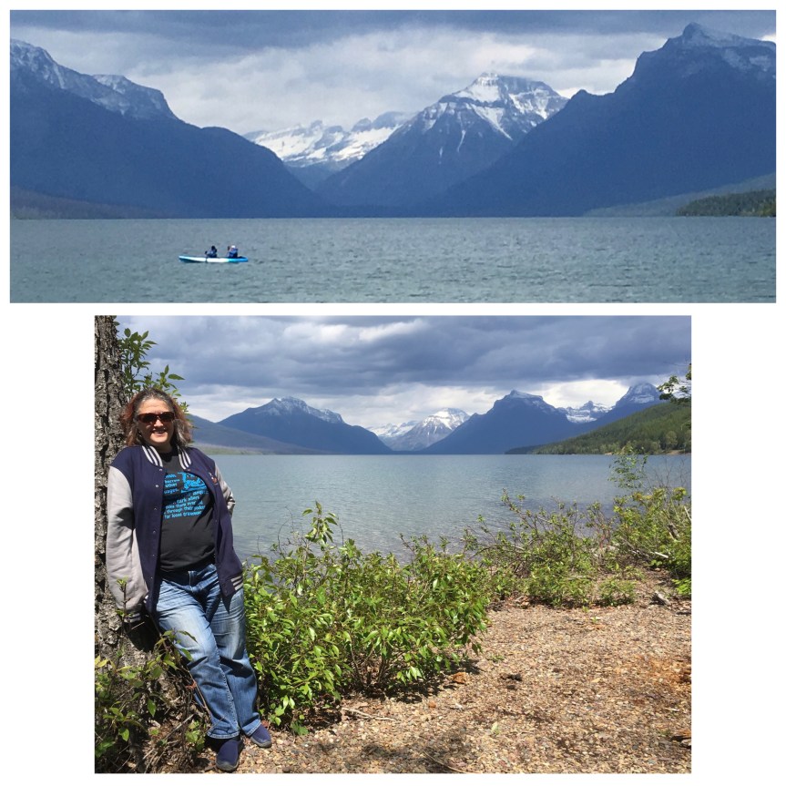
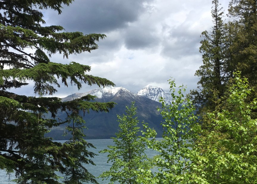
At the Far end of this view are some Glaciers, they are the solid white high in the mountains
As a result of all the recent rains (or snow in the higher elevations) the “going to the Sun” Road which is supposed to be absolutely amazing was blocked most of the way through the center of the park (when you’re in the Rockies) so I could only enter a park-entrance go as far as I could till the roads were blocked, and then back out– go to different park entrance, rinse repeat, etc… so unless I was willing to hike (which I wasn’t) I wasn’t able to get up close and personal with the glaciers and had to just enjoy them from a distance.
I am particularly proud of this picture, note the waterfall off to the left; so nice I posted it twice (so that it would grace the header)… but this is where I took itThis is a very expensive hotel inside the park
It’s begun sleeting really badly, which is not particularly pleasant. I’ve reached Jackson glacier viewpoint, but the road is closed past here and the mist and fog and sleet are so thick that I wasn’t able to get any decent photos… I will have to come back some other year.
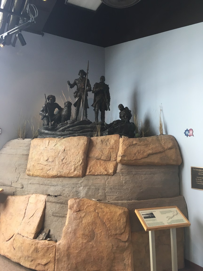
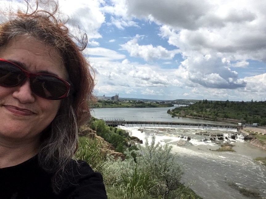
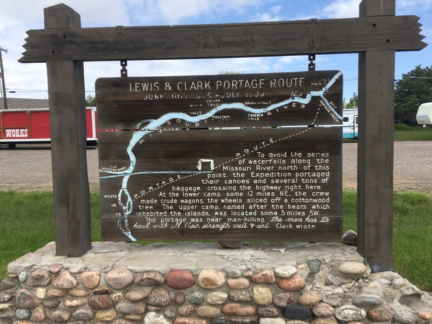
Well developed National Park Center; Explains all about the Lewis and Clark (government funded) Expedition, May 14, 1804 – Sept. 23, 1806, their ‘scientific discoveries’ along the way, and some of the issues they came up against. This location along the Missouri River, in what is now Great Falls Montana, marks the first major hiccup in the expedition — the falls themselves.
For those who don’t REALLY know their US history, let me set the context: An issue I didn’t see discussed in much detail at the Lewis and Clark National Historic Trail Interpretive Center (eeeie what a mouthful!), nor anywhere really (and that includes high school US history books), but one that’s highly relevant to understanding the Lewis and Clark Expedition has to do with the boundaries of the Louisiana purchase… because the fact is they were more than a bit vague. Everyone now a days assumes that Jefferson of course knew what he was buying, but the truth is far from it. Neither the French, nor the Spanish had ever carefully mapped what the thing was when passing it back and forth between them, and other than it’s eastern boundary being marked by the Mississippi River (whose northern end was as yet uncertain) but included various French settlements along it, and in the South by the Gulf of Mexico, it’s northern and western borders were kind of a murky topic — so that when the U.S. bought it, they had agreed to a contract of sale that had very vague language in it.
For the purposes of Lewis and Clark, one of the western/northern boundaries included in the contract was the entirety of the Missouri River — whose limits were UNDETERMINED!!! The further west and/or north they could mark it, the greater the size of what President Jefferson had purchased. Jefferson in fact went one step further (taking advantage of the contract’s vague language) by claiming that because of how the language in the contract was written, the western boundaries would include any and all rivers that drained into the Mississippi (so not just the Missouri, but also any of the waters that drained into it). As such, Lewis and Clark’s expedition also had to try to mark, by Jefferson’s interpretation of the language, just how far north and west that boundary lay.
In other words, BEFORE President Thomas Jefferson had even completed the purchase of the Louisiana territories from France in 1803, he had already begun the process of commissioning multiple explorations to map and explore the contents and boundaries of those unknown and newly acquired lands — as delineated by his definition, which was not likely to be accepted by our geographical neighbors. Lewis and Clark’s northern expedition, which extended beyond the purchase, to investigate what is now the ‘American’ west (territory that, at that time, hadn’t been claimed by anyone — think Oregon, Washington, Idaho and parts of Wyoming), was therefore only one of many groups of explorers that Jefferson had sent out, albeit the must famous of them. In large part, he was hoping that they would find the long fabled (they’d been hoping to find one since Columbus) ‘western passage’– a practical, and easily negotiable route (preferably a waterway) across to the Pacific Ocean; but more importantly, he wanted to send settlers so that America could establish a presence in those unclaimed territories before the other European Colonial powers managed it. And of course, since they were going to be out there anyway, they were to document the resources that came along with those lands, new plants, animals, geography, and if possible open up trade with various tribal groups they met along the way.
As you can see from the above map, the total territory of the purchase, as ultimately marked out by the various explorers, including Lewis and Clark, using Jefferson’s interpretation actually crossed beyond the current 49th parallel borders over into the 50th parallel, or what is now Canada.
The attempt to get that little bit extra is what led to an historical incident between Lewis’s group and the “Blackfeet” tribe’s warriors, which for whites is only an interesting footnote in history, but for the Native Americans has continued to be a very sore point of contention to this day. As is often noted, history is written by the victors, and as such, the story, as told at the center, goes this way:
On the return trip (after having already crossed the Rocky Mountains and followed the Colorado River to it’s mouth) Captain Lewis’ group following the Marias River as far north as they could in an attempt to cross the 50th parallel. The farthest point north they got to was named “Camp Disappointment” because it didn’t go as far north as they had hoped. Retuning from their ‘disappointment’, they met a group of eight young Pikuni“Blackfeet” warriors, who they had a friendly dinner with, but the next morning a fight broke out and two of the natives Americans were killed (shot in the back) in the only violent encounter with any native Americans during the whole trip.
However, as I learned later, the Blackfeet tribal members are STILL pissed off about this incident and blame it completely on the “invaders;” They in fact tell a different story of what happened, and the difference has let continuing ill will on the part of the Blackfeet tribe towards the American people. Additionally, the whole thing was for naught because the British, never accepted Jefferson’s headwaters interpretation of the contract and it remained a point of contention with the US government until the signing of the Treaty of 1818 (which actually has three more names, depending on whom you ask), by President James Monroe, at which time the agreed upon boundary was set to the 49th parallel, where it has remained ever since.
Returning to the attraction itself, apparently following the Lewis and Clark trail is a great favorite with the RV crowd, as I learned at this center, so the National Trails System has invested a lot of money into making the trip worthwhile for them. I also learned that this is not the only federally designated “drive,” but that there are in fact 30 different historic and Scenic ones (and no, I’m not including hikes in that number); Of those ‘drives,’ (other than this one) I’d only so-far spotted two.
The Trail of Tears, which is a bit amorphous due to it’s very nature; it wasn’t one trail; so, instead of a clearly marked path you get a load of signs located on pretty much every government road that existed at that time between the Cherokee territories and what is now Oklahoma, as well as a few waterways. As a result, I had spotted signs for it all over Georgia and Tennessee.
The Appalacian Trail, this one is sort of famous, with folks traveling from all over the world to either drive, or more often to hike it.
In the Lewis and Clark Interpretive Center you will find the obligatory gift shop, an auditorium that hosts lectures, and shows two movies (one about the portage of the boats past the five waterfalls that give the town it’s name, and the other movie was especially made by Ken Burns for the center, and covers the whole history of the expedition). There was an elderly docent, who was a pretty funny guy, who also gave a not G rated speech about the expedition, that he said he’ll only do it when there are no kids in the auditorium (or they are with their parents). Unfortunately, I didn’t have time to stay for that because sidewalks roll up in this town at 5pm and I had other things I wanted to see before then.
Just about a mile or so west of the center are the first set of falls. According to the national park staff person, when they built the dam they intentionally put it a bit back, behind the waterfalls so as to not destroy the “pretty” — there are in fact five of these along the Missouri River near Great Falls, MT (hence the name). These are what Lewis and Clark came up against in their attempt to find the source of the Missouri (which they believed would lead them to the non-existent ‘western passage to the Pacific Ocean’ that they were looking for). It forced them to pull their boats out of the river and move them over land till they got past the falls (uphill) …. only to discover the source of the river was the rocky mountains, and that they could pick up the Columbia once they got past there, but that there was no easy passage — as hoped.
After you leave the Interpretive Center you should also check out the natural spring just down the road (east) from it (see 2nd map)
It is a natural spring that Lewis and Clark found, and they were able to use the clean water from it to help Sacajawea get over a very bad illness that they were afraid it was going to kill her before they had reached her tribe (they needed her as a translator).
Located directly adjacent to the Missouri River, the water that flows from the spring (if you look into it you’ll see the water bubbling up), flows to the Missouri River — making it it’s own river, which has been “named” by the Guinness World book of Records as being the shortest river in the world (but there are a few other ones in Europe 1/2 as long that would argue that).
My national park pass came into use again, also I leaned that if you gave a disability (and proof of it) for $10 you can get a lifetime parks pass, had not heard about that before.
You can just view it from a viewpoint/visitor center off of Interstate 94, or do the right thing and spend the night in the area, and really appreciate the THREE units of the National Park (there are two main ones, and a third small one — the site of Roosevelt’s ranch, which I didn’t find out about till after) in all their dangerous beauty.
I94 Exit 32, Belfield, ND, brings you to the Painted Canyon Visitor Center, where if you don’t have time to really stop and see the place, you can at least get a taste of it. The visitor’s centers tend to have limited hours (they’re usually all closed by 4:30 or such), but if you get there when open the staff are very helpful with suggestions of how best to enjoy the parks, and places to stay
It was also there that I learned about the fact that there are Two main Unites to the park: North and South that are about an hour apart from each other, connected only by government owned grazing pasture lands (not interesting, unless you’re a farmer), each of which will take you a good two hours or more just two a drive drive through (assuming you’ll be stoping for photographs along the way). It was then that I decided I should stay the night so that I could do both parts, and it was a staff member who told me about the Rough Rider’s Inn in Medora and gave me the phone number so I could make a reservation for that night.
North Unit is in fact the better one, to paraphrase the young guide who worked at the Painted Canyon Visitor Center, it has everything the south park does, only twice as big, twice as nice, and there are more animals…. and for all that… fewer visitors.
Like WAY fewer… It was like I was practically the only one there (although not completely alone), I was standing there listening to really loud birdsong and crickets … and I was only a few days shy of the main season. According to the staff I’d spoken too, if I’d shown up a week later, it would be me following a whole row of cars and hearing mostly the sounds of visitors.
To get there from I94, you have to take North Dakota state road 85 (exit 42), and drive for a full 52 minutes north; along the way you’ll drive past the sweet crude gas station and convience store (nice place, clean bathrooms, friendly staff)
There are so many buffalo here that they are blocking the road and I can’t get out of the park!
To get to the entrance to the South Unit of the park, you essentially have leave I94 either at exits 24 or 27 (depending on which direction you’re coming from) towards the town of Medora (which has an historic hotel I really enjoyed), which is sort of a mini cowboy-themed tourist mecca, .
Sadly, I didn’t learn about the Elkhorn Ranch section of the Park, the historic part, till well after I had left the area. As a History buff it might have been nice to see where Teddy’s ranch was (but isn’t any more). But I have a feeling the staff didn’t mention it because it is kind of a let down ….
Helen, Georgia, a tiny GA town with a local population of slightly over 500, is one very large tourist trap of a town aimed at locals of German extraction trying to reconnect to their ancestral roots, or anyone else in search of a little touch of a Bavaria in the midst of the Appalachian foothills. Not worth visiting unless you’re already in the area and looking German food.
Note: I took this trip BEFORE having set up my blog — although I had been intending to do it for months already, so I didn’t take anywhere as many pictures as I probably should have.
I had been staying at my friend’s place in Dalton GA for a few weeks, with the intention of staying a full two months (I remember her saying “I have no idea WHAT you’re going to do here for all that time” — suffice it to say I proved her wrong), and this was near the top of her list of side trips I should consider. The drive there from Dalton was very pretty (as directed by my new car’s GPS device — which I have grown to LOVE, never had one before), and took me there via state highways (think two lane roads) that I would never have otherwise had the guts to take.
For most of the trip I was pretty much alone on the roads, which is both restful and a tad terrifying — when you have no idea where you are. In retrospect (looking at a maps attached to my images) I know now that my GPS took me all along the Richard B Russell Scenic Highway (which is a National Forest Scenic Byway) up over some nearby foothills, through the Chattahoochee National Forest, and and into the valley where the town of Helen is located.
View from GA state road 348
The trip took me about two hours and like I said, I was instinctively ‘lost’ but trusting my new GPS system to know where we were going for most of the way … According to the folks who drove up on their motorcycle (see above image) at this location we are still about 8 miles away from Helen GA.
From a business development perspective what makes Helen interesting is that once they realized that their local industry had failed, rather than kicking a dead horse, they opted for something completely different; taking advantage of their location adjacent to a National Forest they decided instead to become a tourist destination town. Per Wikipedia: “Formerly a logging town that was in decline, the city resurrected itself by becoming a replica of a Bavarianalpine town, in the Appalachians instead of the Alps. This design is mandated through zoning first adopted in 1969, so that the classic south-German style is present on every building, even on the small number of national franchisees present (such as Huddle House and Wendy’s).”
When I arrived I was hungry with a capitol H, having not eaten anything that morning other than a cup of coffee. So, my very first stop was at the first decent looking German restaurant I could find Hofbrauhaus Resturant in the picture at the top of this blog, which at the time also had decent YELP reviews… BLECH. I had one of my favorite childhood dishes, Weiner schnitzel!! As a kid I was one of those incredibly picky eaters who was 10 lb underweight and could drive my mom crazy by going for a full day on three french fries and a glass of chocolate milk. One summer we were in Austria following my dad around as he presented academic papers at conferences, and my mom had discovered I would actually eat Weiner schnitzel, so the first priority was checking if a restaurant served that, and THEN was there anything else on the menu for the rest of the family. So I know my Weiner schnitzel (which I am said to say I can no longer eat because my penchant for everything fried has resulted – I was diagnosed two months after this trip — in liver disease); and to be bluntly honest I was mightily unimpressed with how this restaurant prepared it … as in, “I drove TWO hours for THIS?”
That said, the place DOES have a good view of the river…
The next thing I did upon arriving was, using just my phone phone and the various apps I had on it, I tried to find a decent place to spend the night. There were NOT as many choices as I would have hoped (I have since gotten much more skilled at delving those depths from my iPhone), and at that time I had not yet installed the Airbnb.com app into my iPhone (I was still using a iPhone 4s then, which was already four years old, had VERY limited memory and was starting to slow down from old age), so I was forced to limit my search to national chains — I now know better. I ended up with a room at the Hampton Inn, and since the hotel was half empty I was able to convince the staff to upgrade me to a room with a balcony overlooking the Chattahoochee river for no extra fee.
Once I found out the name of said river I couldn’t help myself, I started singing the Alan Jackson tune, “Way down yonder on the Chatahochee never knew how much that muddy water meant to me…” incessantly. However, looking at the picture, and based on how all the buildings near the river are either on 8 foot stilts or behind equally high restraining walls, I am guessing it floods fairly often.
After having checked in I went to walk around and discovered that this town closes down way early, and from the looks of it most stores don‘t open till noon. Only two stores still open at 5:30 were both owned by what I am guessing are a man and a woman who were both Indian (India) and I am betting are man and wife– work ethic anyone? The whole town looked like it could be part of the German exhibit at Disney-world’s Epcot, the next day when I walked around I discovered that most of the shops have at least one German style hat with a feather in it … only done on the cheap, so that it kind of reminded me of Old Town in Orlando, which I had just lived next door to for about four months, only sans the amusement park rides and haunted houses, etc.
Other than that there were a handful of interesting shops, like this one place that had it’s own hive to produce it’s own honey… but not much otherwise
Why yes, our honey is Fresh! @Betty’s Country Store
Upon checking in, I had told the staff member there how unhappy I had been with the food at the Hofbrauhaus and could he make a better suggestion for my Dinner. He suggested The Bondesee, saying their were the only place in town with an actual chef from Germany, and that it was the place all the locals in town preferred.
And now, after having eaten there… Wow!!! I STRONGLY suggest Bondesee German Restaurant to anyone in the general vicinity of Helen GA.
Walking in the 12 cats who seem to believe that the front entrance of the restaurant is their home (so that the covered patio area which they seem to have taken over stinks of cat urine) would NOT normally have been a good sign, nor would my conversation with the grumpy owner when I swung by there at around 6pm … had it NOT been for the recommendation of a local those two things would have sent me scurrying elsewhere…
However, after having now eaten there, the chef is apparently a man after my own heart in that he seems to believe that there’s no such thing as too much garlic. Seriously, I don’t think The Stinking Rose (a San Francisco institution) serves less garlic… I was in garlic heaven. The butter for the bread was amazing enough to eat without the bread, and the mushroom appetizer came in a cream and garlic sauce that was divine (I had it as a side for my Weiner schnitzel because ALL the sides were carbs (I opted for the Spätzle) … and the portion sizes for me (a single) were more than enough for two people.
The German beer looked dark and a bit scary, but it was very smooth and went really well with the food. Oh, and the OH SO GAY — to the point where he was a caricature of gayness — waiter just CARDED me!!! Talk about how to make a 51 year old woman happy. He looked genuinely shocked to see we were the same age.
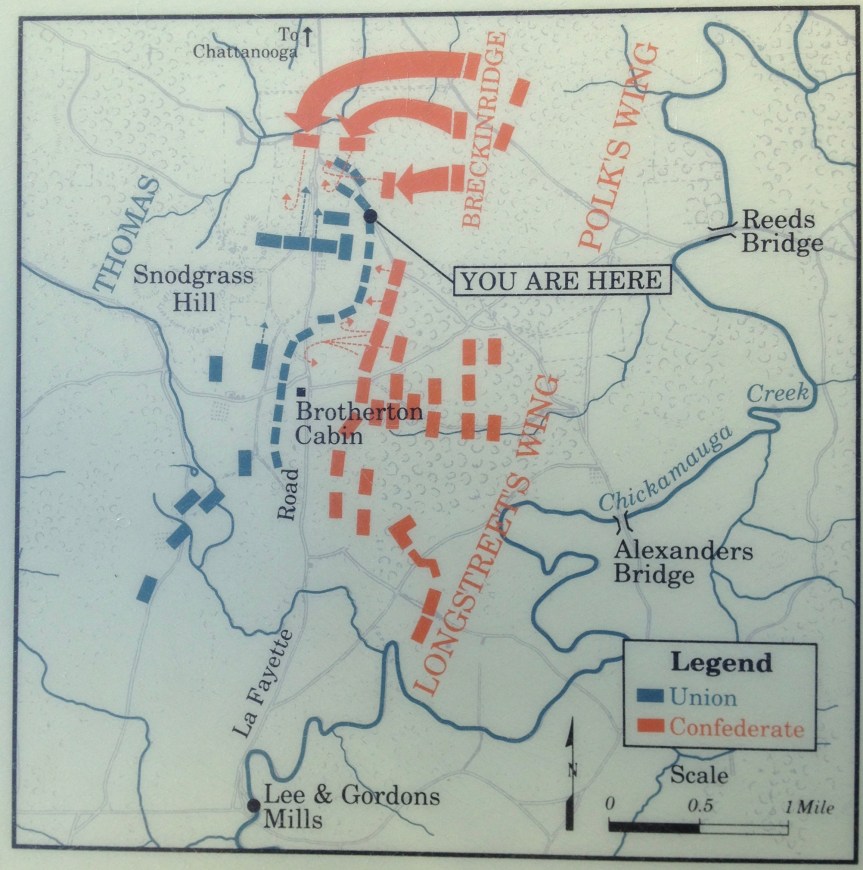
This was the first military park formed in the US. It memorializes the Civil War battle fought Sept. 18-20, 1863. So many bullets flew within these woods during this battle that the surrounding trees because valueless for milling, due to all the bullets embedded within them. If you have any interest in Civil war battles, check out this highly documented park. — Don’t forget to use your National Parks pass.
I strongly suggest that you reserve this park for a nice day when you have a few hours to spend; stop first in the visitor center. There is a 24min documentary reenacting the battle. Watch this first, and then tour the battlefield. Also, in the gift store — assuming your car has a CD player you can purchase a guided tour of the park CD for $10. On various signs around the park you will also find cell phone accessible annotations, but those are far fewer, and interestingly do not duplicate the information available on the CD.
This is completely a aside, but I assume (wrongly of course) when I’m in a historic national park that the other people around share my interest in history… at this location The guy parked next to me was driving a yellow Jeep by the name of the Rubicon, and I told him I loved the name of his Jeep because of its historical nature.
So he said, ‘it is named after a river in California’ and I responded “I think it’s more likely that that river was named after the Rubicon ‘river’ which marks the northern border of Rome which Cesar crossed with his troops, essentially declaring war on Rome itself; this is why the term ‘crossing his Rubicon’ now means passing your point of no return”
He looked a little embarrassed and said, he had no idea that was the source but he probably agreed that that’s why they named the river in California Rubicon … and might be the also named the Jeep that…
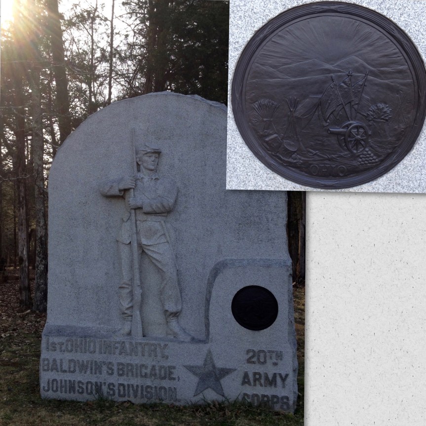
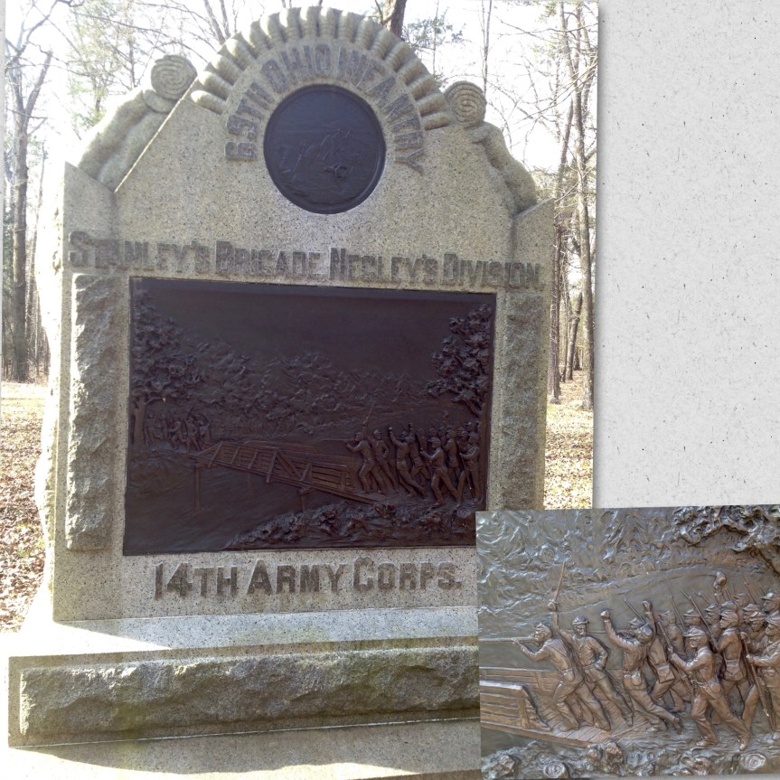
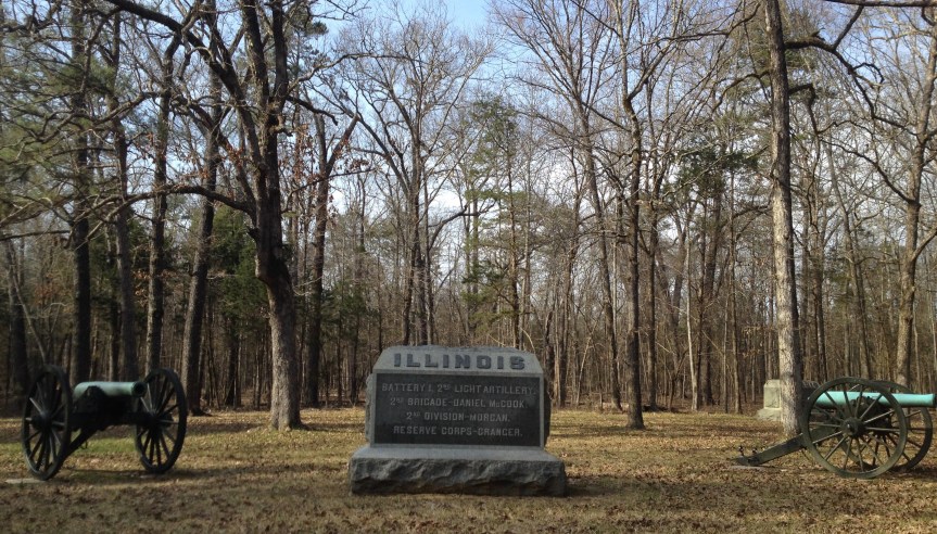
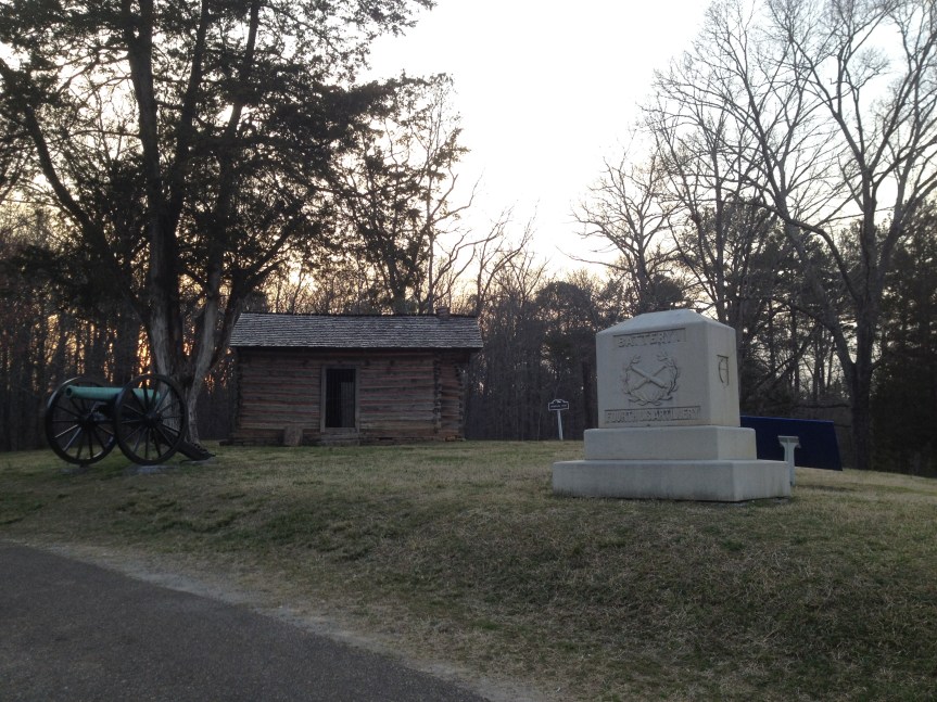
That said, scattered all throughout the park are all sorts of beautiful memorials both to the fallen, and to particular maneuvers that occurred in that location.
As I look at these things I imagine the families of the various regiments and corps, fundraising and organizing in order to pay for these things to be built to the fallen.
And then with signs like this one (above), you have got to wonder, did they bring back soldiers to walk the fields and try to come to a consensus of what events happened where?
This, The Brotherton Family Farm (above) is where miscommunication among the Union generals resulted in a half-mile break in their lines allowing the Confederates to break through.
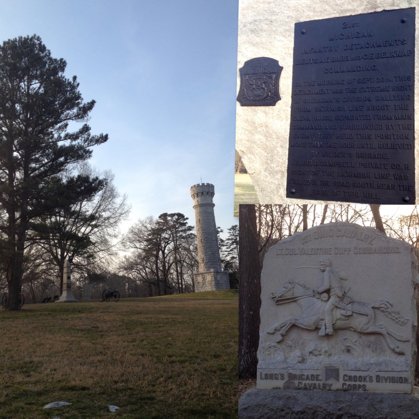
This is Wilders Tower (above), it marks the site where a small group of Union soldiers held back the Confederates long enough to allow the other Union soldiers to retreat to Chattanooga. They were able to do so in part because they had a new technology of repeating gun The sound of which confused the Confederates into thinking that there was a much larger group of Union soldiers here then were actually present. (Also let’s hear it for national park toilets that are out in the middle of nowhere! I had been holding it in for the last hour)
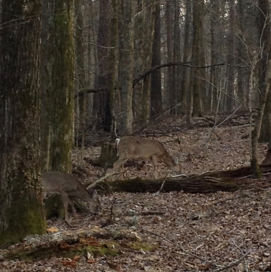
And here is a picture I shot in haste as a group of about 15 baby deer surrounded my car!!
Snoodgrass Hill
The sun was now setting, which I had been warned is when the park closes, so I headed home.


 When I initially parked here I was the only car not on the side with designated parking spot, but instead on the wrong side of the road pulled off to the side as much as possible… I came back five minutes later seven cars (two not visible) had already followed my lead