Lewis and Clark Interpretive Center

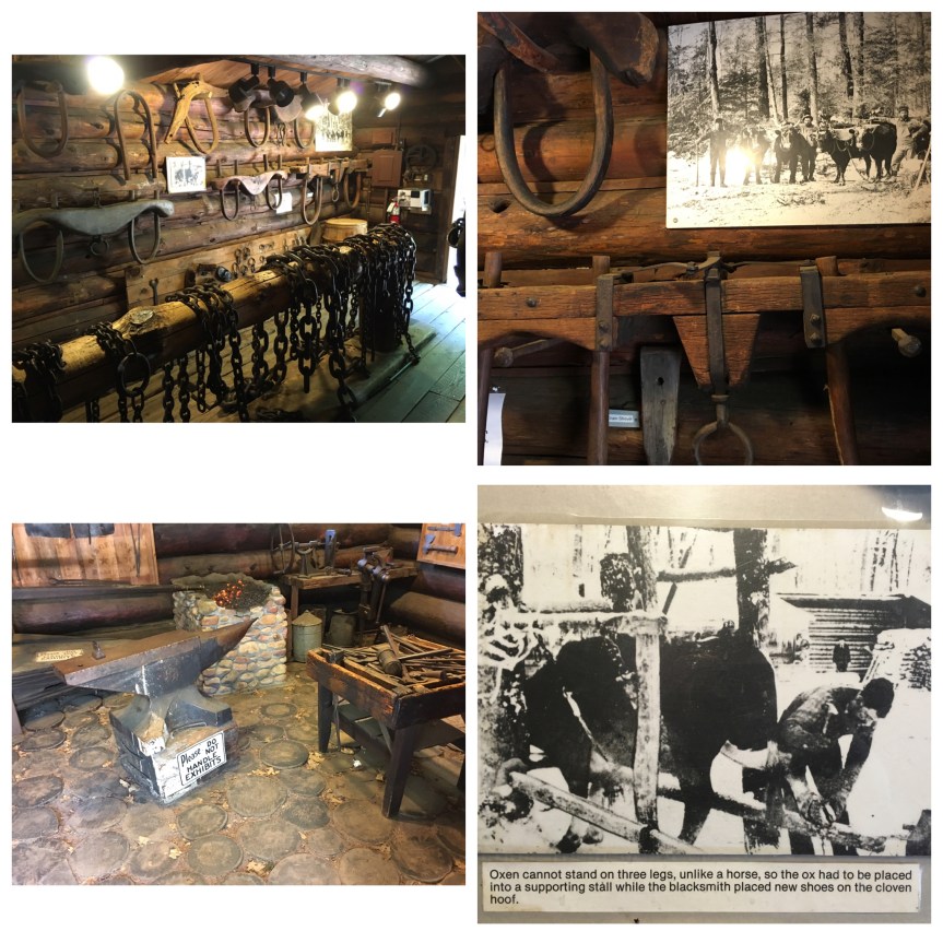
Well developed National Park Center; Explains all about the Lewis and Clark (government funded) Expedition, May 14, 1804 – Sept. 23, 1806, their ‘scientific discoveries’ along the way, and some of the issues they came up against. This location along the Missouri River, in what is now Great Falls Montana, marks the first major hiccup in the expedition — the falls themselves.

IMG_0531

For those who don’t REALLY know their US history, let me set the context: An issue I didn’t see discussed in much detail at the Lewis and Clark National Historic Trail Interpretive Center (eeeie what a mouthful!), nor anywhere really (and that includes high school US history books), but one that’s highly relevant to understanding the Lewis and Clark Expedition has to do with the boundaries of the Louisiana purchase… because the fact is they were more than a bit vague. Everyone now a days assumes that Jefferson of course knew what he was buying, but the truth is far from it. Neither the French, nor the Spanish had ever carefully mapped what the thing was when passing it back and forth between them, and other than it’s eastern boundary being marked by the Mississippi River (whose northern end was as yet uncertain) but included various French settlements along it, and in the South by the Gulf of Mexico, it’s northern and western borders were kind of a murky topic — so that when the U.S. bought it, they had agreed to a contract of sale that had very vague language in it.

For the purposes of Lewis and Clark, one of the western/northern boundaries included in the contract was the entirety of the Missouri River — whose limits were UNDETERMINED!!! The further west and/or north they could mark it, the greater the size of what President Jefferson had purchased. Jefferson in fact went one step further (taking advantage of the contract’s vague language) by claiming that because of how the language in the contract was written, the western boundaries would include any and all rivers that drained into the Mississippi (so not just the Missouri, but also any of the waters that drained into it). As such, Lewis and Clark’s expedition also had to try to mark, by Jefferson’s interpretation of the language, just how far north and west that boundary lay.

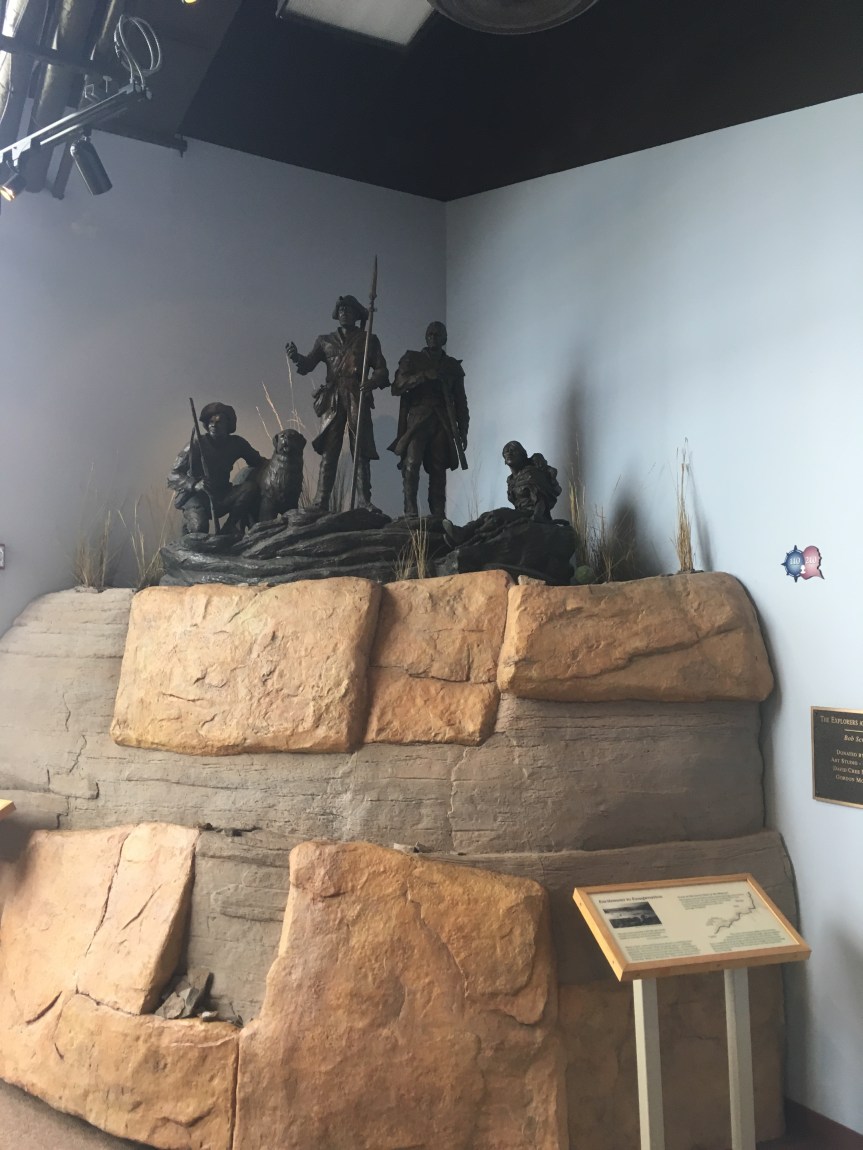
In other words, BEFORE President Thomas Jefferson had even completed the purchase of the Louisiana territories from France in 1803, he had already begun the process of commissioning multiple explorations to map and explore the contents and boundaries of those unknown and newly acquired lands — as delineated by his definition, which was not likely to be accepted by our geographical neighbors. Lewis and Clark’s northern expedition, which extended beyond the purchase, to investigate what is now the ‘American’ west (territory that, at that time, hadn’t been claimed by anyone — think Oregon, Washington, Idaho and parts of Wyoming), was therefore only one of many groups of explorers that Jefferson had sent out, albeit the must famous of them. In large part, he was hoping that they would find the long fabled (they’d been hoping to find one since Columbus) ‘western passage’– a practical, and easily negotiable route (preferably a waterway) across to the Pacific Ocean; but more importantly, he wanted to send settlers so that America could establish a presence in those unclaimed territories before the other European Colonial powers managed it. And of course, since they were going to be out there anyway, they were to document the resources that came along with those lands, new plants, animals, geography, and if possible open up trade with various tribal groups they met along the way.

As you can see from the above map, the total territory of the purchase, as ultimately marked out by the various explorers, including Lewis and Clark, using Jefferson’s interpretation actually crossed beyond the current 49th parallel borders over into the 50th parallel, or what is now Canada.

The attempt to get that little bit extra is what led to an historical incident between Lewis’s group and the “Blackfeet” tribe’s warriors, which for whites is only an interesting footnote in history, but for the Native Americans has continued to be a very sore point of contention to this day. As is often noted, history is written by the victors, and as such, the story, as told at the center, goes this way:

On the return trip (after having already crossed the Rocky Mountains and followed the Colorado River to it’s mouth) Captain Lewis’ group following the Marias River as far north as they could in an attempt to cross the 50th parallel. The farthest point north they got to was named “Camp Disappointment” because it didn’t go as far north as they had hoped. Retuning from their ‘disappointment’, they met a group of eight young Pikuni Blackfeet” warriors, who they had a friendly dinner with, but the next morning a fight broke out and two of the natives Americans were killed (shot in the back) in the only violent encounter with any native Americans during the whole trip.

However, as I learned later, the Blackfeet tribal members are STILL pissed off about this incident and blame it completely on the “invaders;” They in fact tell a different story of what happened, and the difference has let continuing ill will on the part of the Blackfeet tribe towards the American people. Additionally, the whole thing was for naught because the British, never accepted Jefferson’s headwaters interpretation of the contract and it remained a point of contention with the US government until the signing of the Treaty of 1818 (which actually has three more names, depending on whom you ask), by President James Monroe, at which time the agreed upon boundary was set to the 49th parallel, where it has remained ever since.


Returning to the attraction itself, apparently following the Lewis and Clark trail is a great favorite with the RV crowd, as I learned at this center, so the National Trails System has invested a lot of money into making the trip worthwhile for them. I also learned that this is not the only federally designated “drive,” but that there are in fact 30 different historic and Scenic ones (and no, I’m not including hikes in that number); Of those ‘drives,’ (other than this one) I’d only so-far spotted two.

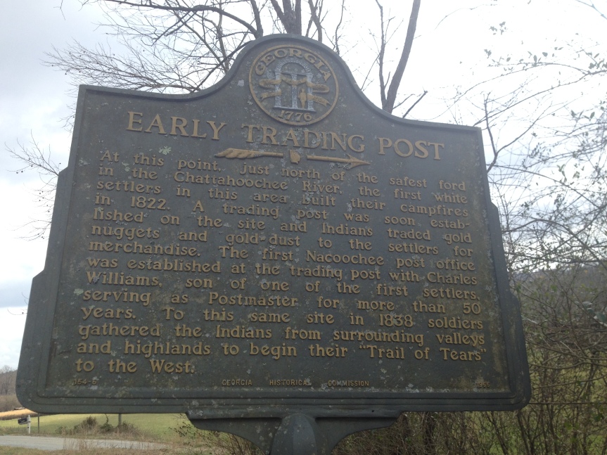
The Trail of Tears, which is a bit amorphous due to it’s very nature; it wasn’t one trail; so, instead of a clearly marked path you get a load of signs located on pretty much every government road that existed at that time between the Cherokee territories and what is now Oklahoma, as well as a few waterways. As a result, I had spotted signs for it all over Georgia and Tennessee.

The Appalacian Trail, this one is sort of famous, with folks traveling from all over the world to either drive, or more often to hike it.

In the Lewis and Clark Interpretive Center you will find the obligatory gift shop, an auditorium that hosts lectures, and shows two movies (one about the portage of the boats past the five waterfalls that give the town it’s name, and the other movie was especially made by Ken Burns for the center, and covers the whole history of the expedition). There was an elderly docent, who was a pretty funny guy, who also gave a not G rated speech about the expedition, that he said he’ll only do it when there are no kids in the auditorium (or they are with their parents). Unfortunately, I didn’t have time to stay for that because sidewalks roll up in this town at 5pm and I had other things I wanted to see before then. 

IMG_0564

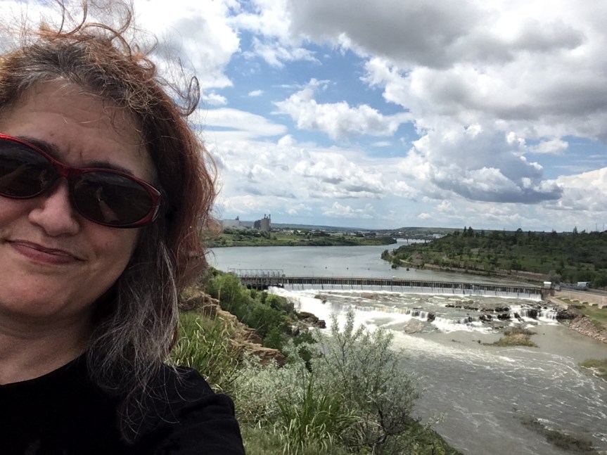
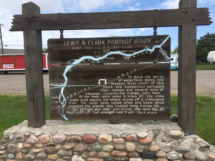
Just about a mile or so west of the center are the first set of falls.  According to the national park staff person, when they built the dam they intentionally put it a bit back, behind the waterfalls so as to not destroy the “pretty” — there are in fact five of these along the Missouri River near Great Falls, MT (hence the name). These are what Lewis and Clark came up against in their attempt to find the source of the Missouri (which they believed would lead them to the non-existent ‘western passage to the Pacific Ocean’ that they were looking for). It forced them to pull their boats out of the river and move them over land till they got past the falls (uphill) …. only to discover the source of the river was the rocky mountains, and that they could pick up the Columbia once they got past there, but that there was no easy passage — as hoped.

IMG_0521

After you leave the Interpretive Center you should also check out the natural spring just down the road (east) from it (see 2nd map)

It is a natural spring that Lewis and Clark found, and they were able to use the clean water from it to help Sacajawea get over a very bad illness that they were afraid it was going to kill her before they had reached her tribe (they needed her as a translator).

Located directly adjacent to the Missouri River, the water that flows from the spring  (if you look into it you’ll see the water bubbling up), flows to the Missouri River — making it it’s own river, which has been “named” by the Guinness World book of Records as being the shortest river in the world (but there are a few other ones in Europe 1/2 as long that would argue that).

My national park pass came into use again, also I leaned that if you gave a disability (and proof of it) for $10 you can get a lifetime parks pass, had not heard about that before.

Five Nations Arts

This place is huge! It’s a co-operative store run by the five local tribes: Turtle Mountain Band of Chippewa, Three Affiliated Tribes (Mandan, Hidatsa & Arikara), Lakota and Dakota. All staff are tribal members and the art is all sold on consignment.

IMG_0294

As a general rule, when buying Native American art if you are not buying it directly from the artist, it’s best to search out these sorts of places, as they never take advantage of the artists — which most other places will do.

The reclining woman tempted me but I do not currently have a local friend to hold on to it for me (I did recently buy a painting in Georgia, which I left at a friend’s home for safe keeping) and she was very heavy (solid stone), so lugging her around in my car till I get to such a location is not feasible. Sigh…

Like I said, I spent a summer doing research into economic development on an Indian reservations (with most rez’s having the highest percentage of poverty in the country). Most native American artists don’t understand the business aspect of their work, and will tend to sell at a overall loss (for a variety of reasons). Gallery’s like this one, which are run by the tribes, ensure that this does not happen. Additionally, most stores that sell NA art, jewelry, etc, add on massive profit margins so that you will pay FAR more buying from them, than from places like this. So it really is a win win to try to search these places out.

IMG_0290


The woman showed me the bunch of really beautiful rings (above) and said “these are made by our youngest artist she’s 8 years old, she’s been beading since she was about two.”


Paul Bunyan & Chippewa Valley Museums

While I came to see the Paul Bunyan, and it was OK, it was the unexpected Chippewa Valley collection that I was deeply, deeply, impressed by — ardently so, to the extent that I would argue that if you’re ever within (let’s say) an hour drive of there, it’s definitely worth making a special trip to Eau Claire just to see it. In fact just before leaving — while telling the elderly woman at the front desk how much I loved the place, I learned that their former curator (who was the one who had set the tone) had been ‘stolen’ away from them by the Smithsonian. Yes, it’s THAT good, but on a much smaller budget.

What brought me to the Paul Bunyan Museum was I had remembered seeing a truly massive statue of Paul (and his Blue Ox “Babe”) when I came here with my mother as a child (maybe middle school aged?). Apparently, based on what other people who also came to see the statue as I was waiting for the place to open, that one had fallen apart and been replaced with this much smaller and far less impressive model.

img_0034With regards to the hand, I saw a bunch of these sculptures scattered all over Eau Claire. I thought that they were a bit like the Chicago cows — which are much larger, also decorated uniquely and scattered around the city — or something of that sort, and it turned out I was exactly correct.

Initially, I arrived at the Paul Bunyan museum just as it was closing. They let me walk in and look at the gift shop collection, but that was it. As such, I opted to spend the night in Eau Claire and come back the next day before continuing my trip westward.  (I stayed at an Airbnb, a REALLY nice apartment in a high rise with an amazing view; the owner made me home-made quiche and some really good coffee for my breakfast.) The next day, because my host had to go the work, and I was intending to not return to her digs before leaving town, I arrived an hour before the Paul Bunyan was due to open.

As I sat there, I was looking at the sky and saw that there was a slight beige tint to it. It’s not as bad as say the skies in Korea but there was clearly a lot of something between me and the blue. I think Eau Claire Wisconsin is beginning to get the downdraft from that contagion of fires spreading all over southern Canada that were why I opted to take Interstate 94 across till I got to Glacier National Park, rather than going straight north and taking the Trans-Canada highway all the way to Vancouver Island, where I plan to spend to months.

The Paul Bunyan museum to be honest struck me as something of a tourist trap-ish… the employees were for the most part a bunch of spoiled teenagers who are paid to essentially sit there and do nothing (LOUSY customer service). When I went there was in fact this one blonde girl who is clearly the bully/leader who was doing her best to avoid actually working, and expected the other employees to stay with her so she could laud it over them. When I finally demanded help, she send over this other girl, a kind of passive and sweet brunette to see what the problem was. It was a rather small museum and most of what was in there in terms of interactive displays didn’t even work.

To be honest the best part of the Paul Bunyan is what I refer to as the “living Museum” part out back — a collection buildings representing a logging camp; and… I saw many locals go STRAIGHT to these, bypassing the completely the building where you pay your entrance fee… and like I said before, all the teenagers on staff were just sitting in there not doing their jobs — which would have included stopping people from entering without paying.

img_6582
Note the Green button on top of the silver box in the bottom right picture, every area had one of these and when you pushed it a “local” in this case the ‘store owner’ would begin offering a detailed narration of the room, its contents, and tidbits of about the life of the loggers who worked there.

img_6583

img_6584

img_0057
Again on the left, the green button you pushed for the narration

img_6585

As you continue back through the buildings you pass through a wooden gate and come to more houses, only these are no longer the logging camp and look more like part of what might have been early Eau Claire, WI, marking the transition to the Chippewa Valley Museum, in the large post office type looking building in front of you (no pic, sorry).

img_6586

Even though the two museums, the Paul Bunyan and The Chippewa Valley, are located right next to each other within a park area (surrounded by a sort of moat — see map below) they are not in fact cooperative with each other — you can not even get a discounted combo ticket for both — because they are their owned by two different groups.

img_0074

The price is the same for both places seven dollars each, but this place which is the non-for profit devoted to the overall history of the area, not just logging, actually has a much better display in my opinion. Rather than having to hit a button, the who place is automated with movement activated ‘background noises’ to give each area a feeling of veracity. So for instance, in the section about how the Eau Claire area used to be devoted to logging and wood industry, as you enter you hear the manager of the woodworkers talking to them about doing their jobs or when you walk into a section that supposed to be a schoolroom children saying the Pledge of Allegiance, that’s what you hear.

img_0094

They also have really taken a good advantage of the video game architecture as a way for people to be able to go back in time and experience various things. … So for instance, fir you walk into an area devoted to the original Native American tribes the lived in the area

img_6587

and in the trading post you can actually in a video game (built by local students) sort of manner interact with the trader. You are a Native American of the region and your language shifts between English and your native language is you negotiate with the trader and socialize.

Perrault’s Trading Post Game from Alex Bostone on Vimeo.
(The actual interaction between you and the trader begins 1 minute into the video)

img_6588

This is followed by a fairly devastating area devoted to the cultural havoc wrought on the tribes when they children were forced into boarding schools where they were forcibly ‘converted’ to meet the cultural norms of the dominate white population. This included a selection of interviews with Elderly tribal members recounting their own memories of the place, and of the abuses.

And then the presentation moved into modern times…

img_6589

Then they talk about problematic things, like the resettling of the Hmong refugees in the area and the problems they had when they came to settle,

img_6591

And then of course there are ‘fun things’ like the local fishing pond

img_6590

And the functional icecream parlor where you can get a snack

img_0177

All in all this was probably one of the best local history museums I’ve ever seen; while there I talked to a local who said as he was walking through one of the sections devoted to what life was like between the late 1800’s and around 1960, also broken down into subject categories (jobs, health, technologies, etc)… as he went through he was reading all of these quotes, and noting to me that they were from locals he knew—  and he’s lived here all his life — so whoever organized the exhibitions clearly had anthropologists and historians going through the community and collecting the local stories and supporting objects from the area in order to re-created the experiences….. and they skipped nothing, the good, the bad, and the ugly… it’s all in there….civil strife, strikes, economic upheavals, it’s all in there …. I am deeply impressed


Sequoyah Birthplace Museum & Fort Loudon Historical Park

Worth a good two hours, possibly more, both attractions are on a man-made island. In the valleys near this location sat both a Colonial era British Fort, and an Indian village that was the birthplace of a Famous Native American; the original valley locations for both the fort and village were submerged in 1979, in order to create the Tellico reservoir, and  island.

IMG_7894

I came here wanting to see Sequoyah’s birthplace, having been told about this it by the folks at New Echota in Georgia, where there is a whole display describing his achievements. Sequoyah was so famous in his day that the trees of the same name were named after him; he achieved this notoriety because, after recognizing the importance of the written language in empowering the invading whites, he sat down and all by himself invented a phonic alphabet for the Cherokee language so that his people too could be literate. And the village in which he was born was called Tuskegee

IMG_7921

Below a plaque in memory of the Cherokee people who had lived in the valley that had been flooded in 1979, and the 191 burial sites that had to be moved to this new burial mound in order to create the Tellico reservoir

IMG_7893

I am putting this on the list of places that I didn’t schedule in near enough time for. I honestly was expecting it to be less than it was. By the time I was getting there, it was due to close in about 10 minutes. I had the phone number and called, and the lady working the desk said she would stick around for an extra 15 for me, and another Family that happened to show up can see the place at the same time I arrived (they had not called).

As I said before, this is not actually the original location, the Tennessee Valley Authority had flooded the whole area to create a electric damn and this is where they move to the his home, and created the visitor’s center which explains all about the history of the tribes, and the import of Sequoyah’s achievements.

Once this place closed, I moved across the street to the rebuilt British fort built there. By the time I arrived the visitor’s center had already close, so I can’t speak to it.

IMG_7928

Behind the visitor’s center however is the fort, which only closes at sundown… and it is kind of seriously cool. It’s a living history museum which includes everything, down to sheets on the soldiers bunks


Hiwassee River Heritage Center

To be blunt, this is a “not yet ready for prime time” educational center about the Cherokee nation and the ‘Trail of Tears,’ which passed along the old ‘highway’ (aka, historic paved road) the center sits next to.  According to the woman who ran the place, they’re still getting funding and were just recently able to buy this building (which looks like it might have been some sort of office). The plan is to tear down the current structure, in the very near future — just a matter of months, and replace it with a much larger facility on the same location.

Currently, all they really have to show are some placards on the wall that tell the story of what happened, which are (I’m pretty sure) duplicates of ones I already saw on the walls of other more developed locations like New Echota (I’m guessing they were gifts from a state historical society or some such). She said that once they expand there will also be artifacts from local digs and research facilities, with a full library, etc. Among the placards was a description of archeological digs done in the area before the Tennessee Valley Authority had put in a damn that flooded many historic Indian sites back in the 1930’s as part of the depression area development of the region, and I assume many of the artifacts will be from those digs.

I look forward to coming back to this place at some later date to see how it progresses.

When I first drove here, I thought that maybe my GPS had failed me, because there were no signs leading to here, but happily, there are nice clear signs out front. Then I saw the sign on the door… firstly, the author forgot to include the local area code and not being a from there I had no idea what to dial, and secondly, my T-mobile phone had no signal, as in none. I went next door to the gas station and asked a nice young guy if he had a working cell phone and would he please call the number for me. The woman who runs the place was apparently 15 minutes away running errands, but said to wait for her.

While doing that, I went next door to a nice looking antiques place (other people’s junk), which actually had a few things worth buying, as a well a huge collection of abandoned family photographs that go back to the 1800’s (we don’t recognize any of these relatives so what will you pay us for them). It was kind of sad actually. The woman who ran the place gave me a free copy of a book about the history of the area written by a local man.

New Echota Historic Site & Museum; Calhoun, GA

A memorial to, and attempted recreation of, the former capitol of the Cherokee nation (before it was uprooted and moved west during by President Andrew Jackson‘s trail of tears — one of the more disturbing events in US history).

I have very mixed feelings about places like this. On one hand, its good to see the dirty linen being laid out in the open, an attempt at some sort of ‘mea culpa‘ by the people of Georgia (yes our forefathers were dirt bags) … on the other hand, it’s a state park, and this benefits the state of Georgia and helps bring tourist dollars to the area. Because, let’s be real, the state of Georgia, and the ‘founders’ of the town of Calhoun, GA are the same people who eradicated the town in the fist place (of course with the help of Jackson, everyone’s favorite president–NOT!) and while I’m glad they built/are building this place, and I doubt it’s much of a money maker… I question the motives that created it as much as I appreciate the results.What I would have liked to see but didn’t (which does not mean it isn’t happening, just that it wasn’t front and center in the museum) evidence that tribal elders are somehow involved in this site, etc.

However, that said…


IMG_7221


IMG_7612

The New Echota site and museum is open Thurs-Sat, the web site says it’s open on Wednesdays, but the one time I went there on that day it was closed. The visitor’s center includes a small museum, and a 17 minute movie (also visible here) but most of it is outdoors, where they have tried to recreate some of what was there, and you are left to walk it alone at your own pace (as such, it’s better for a nice weather excursion). It’s a Georgia State park and marks some of the land that was supposedly the location of the national Capitol of the Cherokee nation before they were forcibly removed during the Trail of Tears. Counter to the Hollywood stereotype, they lived in western type wood homes, grew crops, had their own written language developed by Sequoyah, their own newspaper which had a world wide distribution (according to the docent), and literacy within the nation actually was higher than among the surrounding white communities (but at the time that wasn’t all that hard to achieve). During my second visit there (when it was open) It was Spring Break for a lot of the schools around the country, so there were a lot of kids and parents even though it was mid week.

IMG_7611

Essentially its part of the land that they historically know the town was built on, and they’ve managed to rebuild a few of the building, etc., except for the home of the local missionary, which I believe may still be the original although massively refurbished. According to the docent the most accurate re-building is the printing house, because the soldiers who destroyed it had thrown all the metal print blocks out the windows before burning the place, and when archeologists did a dig they found them marking an almost perfect square on the ground. In addition the state’s historian had found that the missionary had sent in highly detailed requests for what had been needed to build the place, so that there are records of how many nails, sheets of wood, dimensions, etc.

IMG_7571

One of the really cool things about the place is there’s a website they’ve created with a narrated walking tour for almost every building on the site that you can load to your smartphone/tablet at the ‘entrance building’, and then pull up each description when you reach that particular building.

Chief Vann House; Dalton, GA

Highly educational restored home that will blow away historically inaccurate, Hollywood based, preconceived notions of who Native Americans were in the early 1800’s.

If you are in the area and have little hard knowledge regarding the original inhabitants of what is now the United States of America, than I strongly suggest a visit to this historic house if only because it may help to destroy some of your misconceptions regarding who the Cherokee were at the time of the trail of tears (1838-1839).

Most Westerners (and in this I include Americans and Europeans), based on what they have learned from Hollywood films, etc., seem to believe that all Native Americans were backward, or refusing to integrate into western society and that was the reason they were moved westward to what was called the “Indian Territories”, but this is woefully incorrect. In actuality, the reason the native inhabitants were removed had more to do the the recent discover of gold in their lands in 1829.  The historic location I visited today is the restored home of Chief Van, a Native American so rich that he owned at least 100 slaves, a bunch of paddle wheel river boats, many trading posts, etc.

IMG_7321  IMG_7304

He was one of the influential Native Americans of the time who were using the American Judicial system to fight for the rights of his people, and with varying degrees of success in that regard (think of this as the first time that America Judiciary and the southern states came into direct conflict with each other — a pattern later repeated with civil rights, abortion, and then gay rates, et al). In spite of all of his wealth, and power, he made the major tactical error of hiring a white overseer when it was illegal for an Indian to do so (the states had been passing laws restricting the rights of native Americans that were not all that dissimilar to the segregation laws after the civil law, or to what Hilter later did to the Jews in Germany) thereby giving the federal government cause to kick him out along with the rest of the Cherokee during the trail of tears (only he took all of his furniture, slaves, etc. with him and continued to be very rich).

IMG_7294

The house is SO fancy that it had a floating staircase and a fancy interior paint job with pigments most people of the day could never have afforded, and president Monroe had spent the night there when visiting the area.

IMG_7315

After I leaving the house I drove past the first swamp I saw in Georgia. According to the  docent at the Vann house, Spring Place which is the town where the house is located is the poorest part of the state, I guess this was the proof.


Nacoochee Mound & Sautee Nacoochee, GA

While the Indian mound is essentially a mildly offensive tourist trap, the tiny village of Sautee — just down the street — is in my opinion well worth the visit:

fullsizeoutput_332b

Located in Georgia, just outside of Helena, there is this Indian mound that really impressed me, at least until I learned from online sources (such as Atlas Obscura) that it had already been excavated, and then replaced (and is therefore a replica rather than the original) — a fact that none of the signs at the location tell you … nor one shared with me by locals.

The area in which it sits could best be described as countrified yuppie. It’s all gift shops and locally made artesian soaps cheeses and art etc., none of whom I suppose have any motivation to tell the truth about historical mound their shops are adjacent to. Not only did the locals not share the actual facts with me, I was, I would argue, actively misled by them. I can’t remember if it was the saleswoman at the racist antiques store across the street (which sold Sambo dolls and ‘Song of the South‘ DVD’s) or one of the other locals business people who initially assured me that the mound was an Indian burial mound that had been kept in “almost pristine condition” in large part because of the gazebo that a local farmer had opted to place on the top, that kept him and future farmers from leveling it.

In fact, if you look closely and read the sign, and then go to this site, you’ll discover that the sign is mostly a pack of lies!!!! There is no evidence that DeSoto visited, and archeologists are fairly certain that the mound predates any Cherokee habitation of the area.

Consider for instance “legend” that is associated to the mound:

“The legend of the Nacoochee Indian Mound states that Indian lovers from opposing tribes are buried within the mound.  Sautee, a brave of the Chicksaw Tribe, and Nacoochee, the daughter of a Cherokee Chief fell immediately and hopelessly in love when a Chicksaw band stopped in Cherokee territory at a designated resting place.  The two lovers met in the night and ran away to nearby Yonah Mountain to spend a few idyllic days together.  When they later confronted Nacoochee’s father with the idea of creating peace between the two nations, Chief Wahoo ordered Sautee thrown from the high cliffs of Yonah Mountain while Nacoochee was forced to watch.  Almost immediately, Nacoochee broke away from her father’s restraining hands and leaped from the cliff to join her lover.  At the foot of the cliff, the lovers dragged their broken bodies together and locked in a final embrace and died there.  The Chief, overcome with remorse realized the greatness of love and buried the lovers, still locked in death, near the banks of the Chattahoochee River as a burial mound.”
source: Southernhighroads.org

Seems a bit TOO Romeo and Juliet for my tastes… that and the fact that the mound is listed on the National registry of historical places may, in actuality, have more to do with it’s having been located on the estate of L.C. Hardman, a former Georgia Governor, than anything else. … none of which I learned till I started researching the location for this blog post.

I have to say that in retrospect, as someone who has deep personal connections to the Native American community, I felt a bit ‘ripped off’ by my experience at this location. On the upside, it’s not someplace I went out of my way to see, it just happened to be along the drive… but that said, some honesty would be appreciated! I suppose I shouldn’t have been surprised, considering this is located just outside of Helen, GA, (notable only for German architecture and restaurants — only one of which is any good — it is essentially a tourist trap aimed at anyone in search of a little touch of a Bavaria in the midst of the Appalachian foothills).

That said, directly adjacent is one of the actual gathering points (of which there were many) for the Trail of Tears… a forced relocation (that for those Native Americans not affluent enough to purchase transit devolved into an ultimately genocidal/ethnic cleansing) of the south eastern United states, during the administration of Andrew Jackson.

IMG_7191

 fullsizeoutput_332c

That said, I did find one major “FIND” a bit further down Unicoi turnpike… first you’ll find a very cute “village/crossroads” (not more than few stores) of Sautee Nacoochee which includes the ridiculously picturesque Old Sautee’s Store and market,

IMG_0002

walking distance from which you’ll find the Folk Pottery Museum of Northeast Georgia, a museum for the Traditional pottery of the area, built as an annex to a converted historic school, which now serves as the Sautee Nacoochee Center, a gallery and visual arts center for local artists (and a lot of what they have for sale — and at affordable prices considering it’s original art…  are, at least in my opinion, really good)

IMG_0001